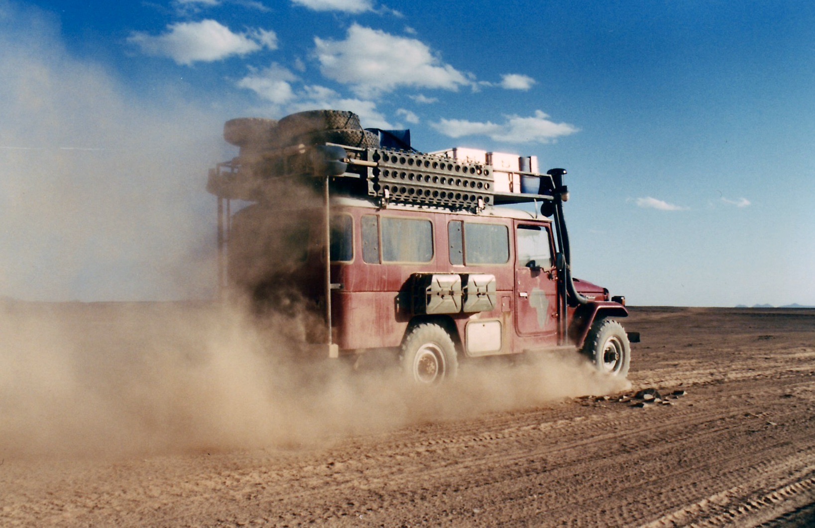
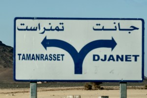
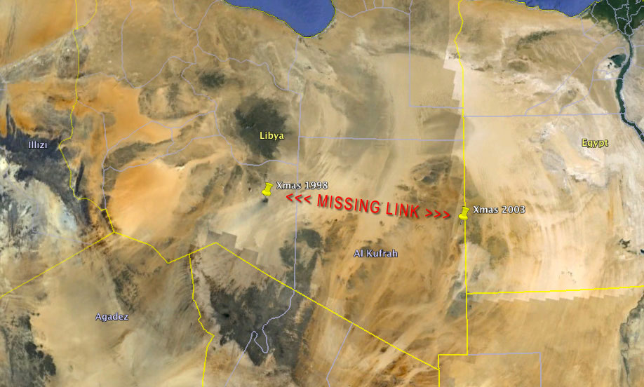
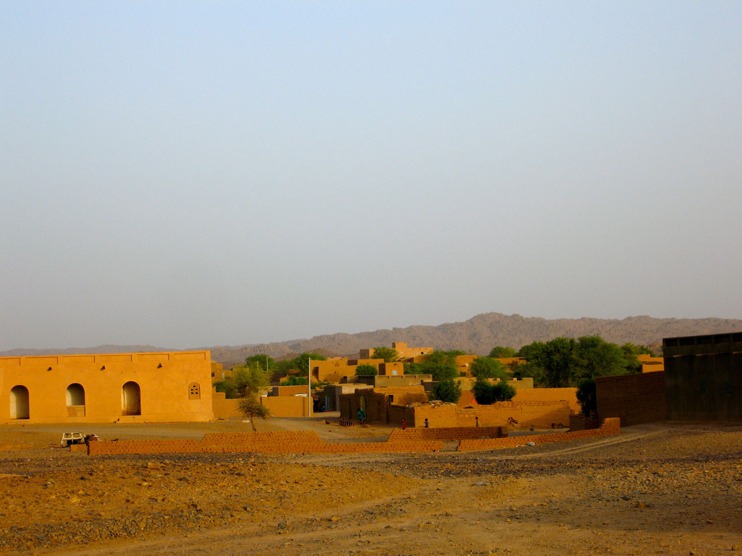
These two southern Algeria towns will soon be joined with a ribbon of asphalt called the N55. In fact it’s said in April 2026 the job has been done, though it has yet to be independently verified. It’s worth knowing that according to the Djanet gendarmerie who give permissions, for some baffling reason, from Djanet this road is closed to tourists, even with a guide. We drove it eastbound in 2025 with a guide with no problems. Maybe eastbound from Tam makes a difference, as you can say that from Bordj you’re heading north to Illizi, even though it’s straightforward (and an amazing drive) to carry on east to Djanet which is a dead end (no open borders to Libya or Niger). In April 2026 sat imagery showed the gap in the tarmac had shortened in the west by about 9km to 85km. But as said, it may all be sealed. Soon we will know for sure.
How the surface with survive the baking summers and pummelling of trucks remains to be seen, but that’s been an issue since they finished Trans Sahara Highway from Algiers to Tam in the early 1980s. It’s said the TSH remained intact over its 2000-km distance for just one year before flash floods, poor engineering and overloaded trucks beat the bitumen back into rubble. In January 2025 we did the full TSH too; there’s probably 100km of diversions over sand and gravel.
Djanet to Tam This description may be out of date now but about 8km west of Serouenout checkpoint (270km from Djanet) the tarmac ended in 2025. After 24km there was a short, 20-km section of tarmac, and then you’re back on the piste south of the new road’s alignment for about 70km. Once back on the road around 24.264, 6.4864 (if not already), it’s about 80km to Ideles roundabout (fuel in town) and another 140km on to Tam via In Amguel on the TSH, or about 190km along the scenic ‘Hoggar Ring Road’ via Col Azrou and Tahifet.
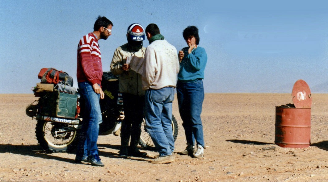
Puzzled near Borne; 1987
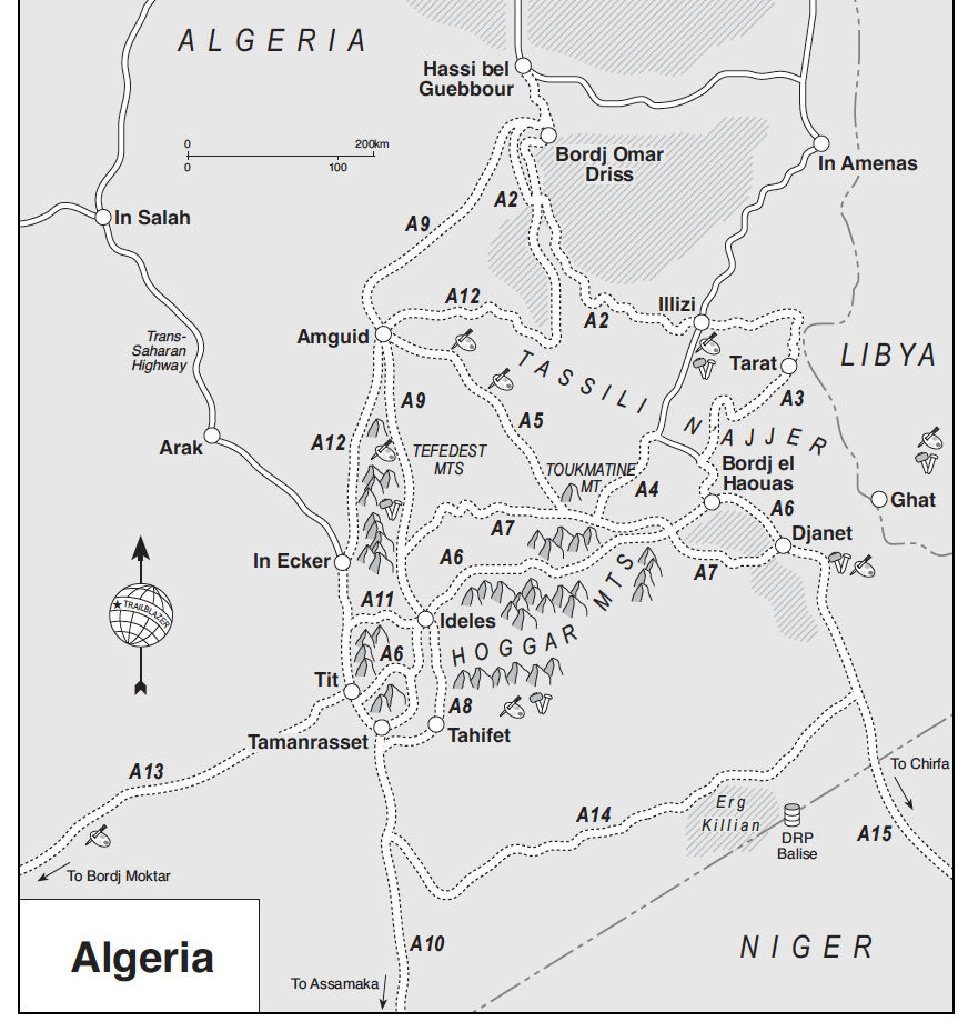
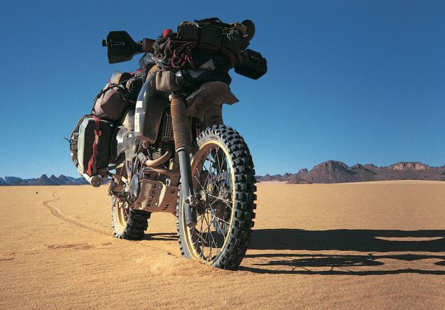
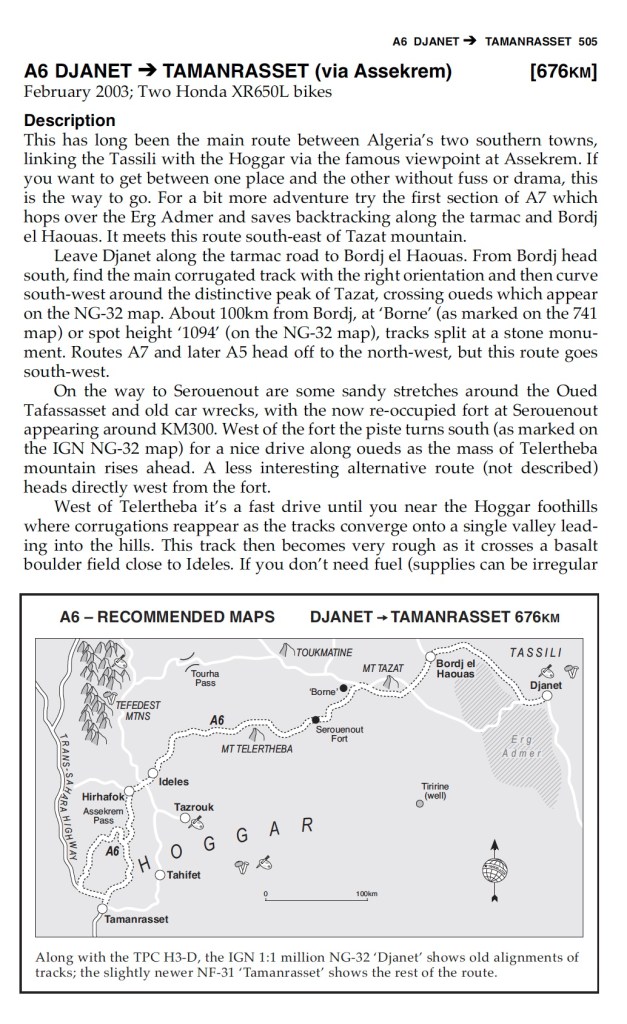
Sahara OverlandRoute A6 In the good years (1970s, 80s and 2000s) various tracks between Djanet and Tamanrasset and Hoggar mountains all combined to make classic multi-day adventures in southern Algeria.
Heading west on Route A6, (the current N55 road), you traversed below the ramparts of the Tassili N’Ajjer plateau, long famed for its prehistoric rock art, then either turned southwest at Bordj el Haouas for Tazat mountain (below right), or used the same mountain as a landmark after crossing the dunes of the Erg Admer (below left; Route A7),
Admer 1989Tazat mountain, 2002
Passing isolated volcanic cones, plugs and other outliers, the basalt rubble from the once molten Hoggar raised you up to Assekrem, a few hours from Tamanrasset and a refuel. The main route used by non-clandestine locals (A6 in my old Sahara Overland guidebook bottom of the page) was still nearly 700 kilometres or two desert nights for most. It was also on the limit of what a moto could manage alone.
Sands of the Ajjer, 1987
When I first did it in 1987, the road from the north ended in Illizi, 400km from Djanet over the Fadnoun plateau. That all added up to over 1000km and one of the best all-dirt stages in southern Algeria (above), with just enough pre-GPS navigational challenges to keep you on your toes. It was rare to pass more than one or two other vehicles during the transit.
Nearing Tam (1989)Descent from Assekrem (2003)
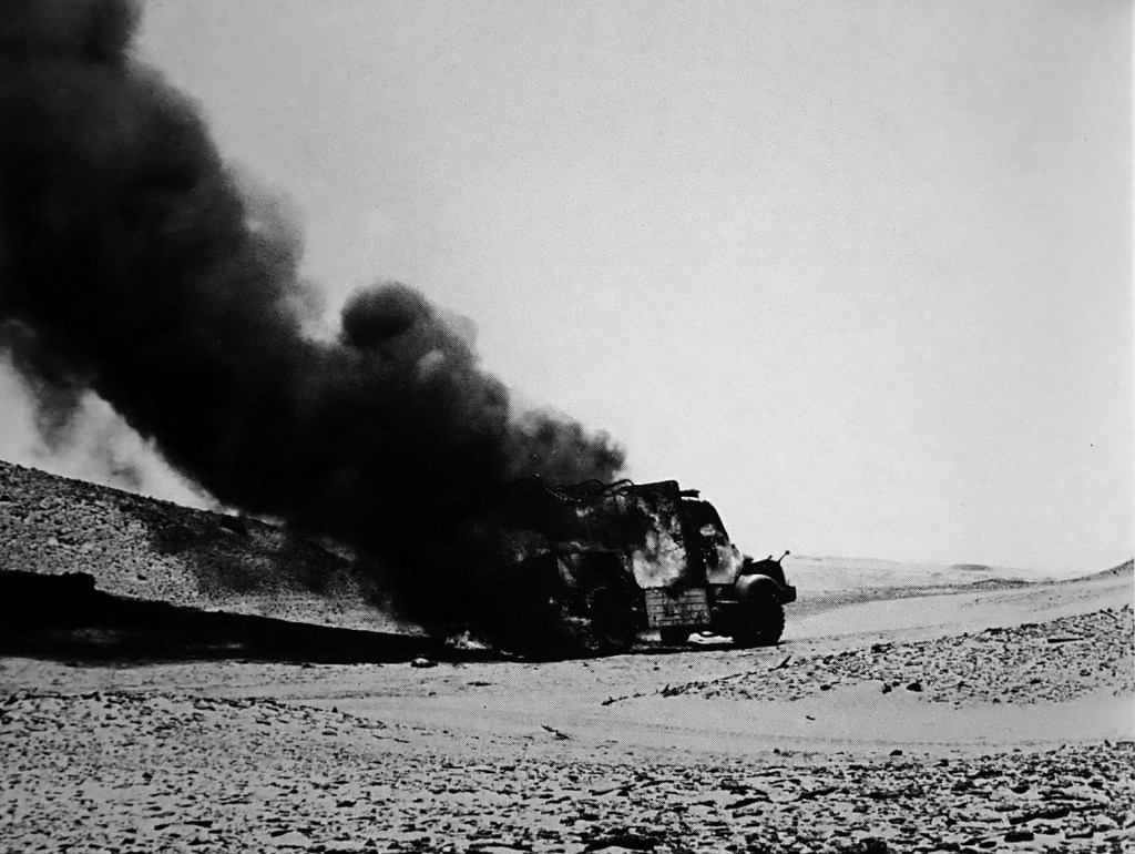
Fallen MAN
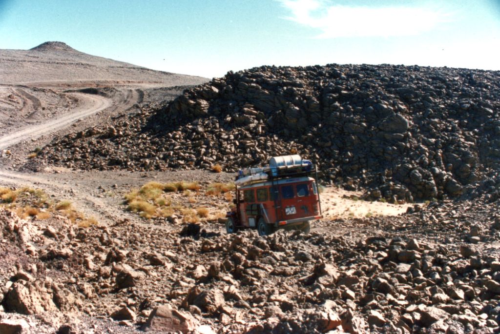
In the 1980s the army were tasked with building a road over the Fadnoun’s switchback escarpments. Up to that point, trucks supplying isolated Djanet had to take a huge, sandy detour to the west via Amguid, nearly doubling the road distance. After about ten years the Fadnoun (below) got sealed and today is still a great drive, even if the road is breaking up here and there and occasionally lorry drivers fall foul of the Fadnoun’s curves (left).
Gara Ihadja n Kli, one of the Fandoun’s escarpments, 2018
Morocco is famed for sealing it’s southern desert pistes faster than we can keep up, but Algeria has been catching up, only over vastly greater distances and probably with access restrictions to the military. A whole network of ‘hidden’ border highways, remote military bases as well as vast defensive sand berms (below) have emerged in recent years to control migrant traffickers coming up from the south.
Border road and berm with Niger, far south of Djanet
Even though they’ve succeeded in sealing this traverse, A6 Tam-Djanet (N55) still remains one of the great routes in the Sahara and there’s no need to follow the new road. There is A7 to the north which we also partly did in 2025, A14 in the deep south I last did in 2007, and at least one more route via Tiririne, Tarabine which we did in 1989 and again in 2006 on the way back back from Mauritania on Sahara: The Empty Quarter. For me this was all before gpx tracklogs but these routes are probably traced on OSM maps or Wikilocs. So do not be put off by the road being officially closed to tourists. As long as you (and your guide, if present) are prepared and equipped to tackle these pistes, they still offer some of the best, long-range routes in the central Sahara.
Rubble tracks into the Hoggar (’87)Desert Riders camp south of Tazat ’03)
Book Chapters: 16 Arak 17 Bad Day at Laouni 18 The Far Side 19 A Blue Man 20 The Hills are Alive
After my batty Benele excursion of 1984 I brushed my hair, straightened my tie and bought a sensible XT600Z, just like I always knew I would. This was the slightly better 55W version of the original kick-only Tenere, distinguishable by sloping speedblocks on the tank (more here). All I did was add thicker seat foam and fit some Metzeler ‘Sahara’ tyres – a rubbish choice for the actual Sahara, as I was to learn. Using no rack was another mistake which nearly cost me the bike. My learning curve was still as steep and loose as a dune slip face. In fact, there was so little to do to the Yahama that I moved the oil cooler from down by the carbs up into the breeze over the bars. And I painted it black because I still hadn’t shaken off my juvenile Mad Max phase.
With my £5 ex-army panniers slung over the back, in December 1985 I set off for Marseille, bound for Dakar via Algeria, Niger and Mali. As I mention in the book, I was going to try a new ‘go with the flow’ strategy’. Instead of being ground down and resentful by the setbacks of my previous adventures, I’d just take the reversals on the chin, bounce back, and move on. On this trip that stoic philosophy was to get a thorough road test!
Zoomable Map LinkA chilly desert morning somewhere south of Ghardaia. Further south there isn’t enough humidity to produce overnight frost.Back at those first proper desert dunes north of El Golea (today: El Menia). What a crappy, lashed-up baggage system!I return to Arak where I’d got detained on the enervating Benele trip the previous year for being an idiot.Here I meet German Helmut on an old, ex-police R90 BMW. We are both planning to cross the Sahara so agree to meet up in Tam a couple of days down the road and do it together.A pose south of Arak. full black leathers, HiTec Magnum desert boots, and my dainty British Airways nylon scarf.View of Sli Edrar: my aborted destination on the Benele trip. Even now I was too nervous to ride the 10km across the desert to the hills. What would happen if i hit quicksand?! It takes years to get used to being out there. Or it did me.Sli in 1982 on the XT500 trip.I finally got to Sli Edrar 17 years later from the other side.while laying out fuel caches for Desert Riders.And in 2008 we had a great afternoon riding Sli’s granite domes on one of my epic Algerian bike tours.The worse thing about those rubbish 2-ply Metzeler Saharas, was that I bought a spare. Back then there were no hard-wearing Heidenau K60s or Mitas E09s.In Tamanrasset I meet up with Helmut and we take an overnight excursion up to Assekrem in the Hoggar mountains.Helmut on the R90. The overnighter was a good chance to test our bikes.Sunset from the Hermitage at Assekrem. ‘There was no one there..’.A chilly camp, high up in the bleak Hoggar.On the less used western descent down from Assekrem, near the village of Terhenanet Helmut deftly flips his BMW. The rounded gravel in this particular oued is unlike anything I’ve found in the Sahara. I barely made it across myself.A day or two later, Helmut lightens his load after the lessons of the Assekrem excursion and we set off into the night to cross the Sahara to Niger. We camped a short distance out of Tam in the hope of getting a good run for the 350km to the border in a day.Next morning we come across some Swiss riders. One of them flipped and cartwheeled his 80G/S and and now it won’t start.Helmut knows his BM from his elbow and sorts it out: a barrel flooded with oil. Look at the huge load on that other Tenere compared to mine. This was one of the reasons why I felt it was my duty to write Desert Biking a few years later. That book evolved into the Adventure Motorcycling Handbook.As that day wore on, Helmut got progressively more and more tired from frequently falling off his bike. One final crash around dusk finished him and the BMW off.With his shoulder damaged and so unable to ride, I persuaded him to give his BMW a Viking burial with the loads of spare petrol he had left over.The remains of Helmut’s trans-Sahara ride next morning. We abandoned most of his gear and he squeezed on the back of my XT. It was galling for him; he came off quite a lot worse than I did on my first attempt at crossing the Sahara in 1982 on an XT500.After leaving Helmut at In Guezzam, the Algerian border post, I set off across No Man’s Land for Assamaka: the Niger border. It was New Year’s Day, 1986 and the Dakar Rally was leaving Paris.As I say in Desert Travels, the Sahara Handbook of the time warned of the very sandy conditions in No Man’s Land, but in fact the terrain wasn’t so bad. When things are tough or in times of stress I tend to press on; when they ease up I feel it’s safe to stop for a breather. So even though it wasted precious film, I had the notion to take some aerial selfies by setting the camera on self timer and throwing it up in the air.Most shots were of gravel or sky, but here’s a superb pre-drone-era snap of the Tenere from 20 feet up.After checking into Niger at Assamaka – a portacabin and mud hut in the middle of nowhere, next day I got lost on the last 200-km stretch to Arlit where the road resumed. And not only that but just before I got there, my canvas baggage caught fire (pressing on the pipe; the usual story). One pannier burns merrily in the stiff Saharan breeze.I wasn’t carrying that much stuff; now I had a bit less. Notice the H4 light bulb.My first Saharan crossing had been quite eventful. See the Google Map.A few days later I arrived at the banks of the Niger river. West Africa was a whole different vibe from the Sahara and North Africa.After struggling along the very sandy riverside track from Niamey (Niger) into Mali, I camped on some dunes above the river. As the sun set, over the river I could hear drums beating in the villages.Next morning I reached Gao, located the ferry over the Niger (there’s a bridge now), and headed straight to Bamako as my Mali visa only lasted a week. But I got a puncture and encountered the Blue Man as described in the book. From here on I’d have many punctures from thorns I picked up while battling along the sandy bush track to Gao.The famous monoliths near Hombori, Mali.Another monolith in the morning haze.The fabulous Grand Mosque of Djenne (not my picture, can you tell?).I’m now sick with the shits but need to rush on to Senegal before the visa expires. In Bamako I gave up trying to get my bike on the train to Dakar, as most people did back then because the roads were so bad. So I take the direct route to Kayes and the border. After all, I’ve crossed the Sahara and am on a trail bike, how hard can it be?The track follows the Dakar railway which helped with orientation. Just as well as I got lost again and again. Unlike the desert, there are loads of bush tracks linking village to village.Waiting for the non-existent ferry at Bafoulabe. After a while I realised there was a bridge just upriver. How else would the train get across. You can see my perspex numberplate has succumbed to the piste; a common problem. Small metal plates are better.Rough tracks in west Mali heading towards Kayes. Few people took this route and I don’t recall passing any other vehicles. From Kayes it was another 100km to the border which I had to reach that night.But there is time for a quick look at the Chutes de Gouma, west Mali (see map).Passing through Kayes that evening, I learned that Dakar Rally founder Thierry Sabine, had been killed with several others in a helicopter crash. January 14, 1986.Somewhere after Ambidedi, I crash out myself under some baobab trees. I was still sick and too tired to carry on, visa or no visa.Next morning I reach the border, now with two flat tyres, but accidentally manage to slip out of Mali unnoticed. With no more patches, I get a train to Tambacounda where I meet Al Jesse, of Jesse Luggae fame. He gives me a spare tyre (my own got ruined from being running flat with the rim lock done up.I think my cameras had packed up (another common problem) but I still had film so Al took some pictures of the Dakar finale for me, including Gaston Rahier #101, signing Al’s BMW 80ST which he’d ridden down from the Arctic Circle in Norway, two-up.Gaston Rahier in action.The Marlboro-Elf team. Imagine racing those tanks off road for up to 1000km a day.That year RothmansPorsche 959s got 1 and 2, and Neveu and Lalay did the same on Rothmans Honda NXR 780s (which became the original XRV 650 Africa Twin two years later). What a great result for Rothmans – if that won’t get you smoking, nothing will! Serge Bacou – cool centre stand (not my pic).Al inspects a Honda 125 #1. I have failed to find out who this was, or if it was an actual finisher.
The route was similar to mine, but twice as fast, half as long and many, many times as hard.From Dakar I ship the XT to Spain and fly on after it. What an adventure that was!Weeks later I got a postcard from Helmut.London to Dakar on an XT660Z Tenere. Next?!
This is part one of a bonus chapter which does not appear in the book.
You’d think I’d have learned something after my 1982 Saharan fiasco on the XT500. Well I did. Despite it all, I was still fascinated by the Sahara and wanted to go back and do it properly this time. When it was good it was epic and other-worldly, and if you came from one of the less edgy suburbs of South London, the Sahara made quite an impression: nature stripped back to its raw bones of sand and rock. Across it lay the frail ribbon of road they called the Trans Sahara Highway which I’d ridden off the very end of a couple of years earlier on the XT.
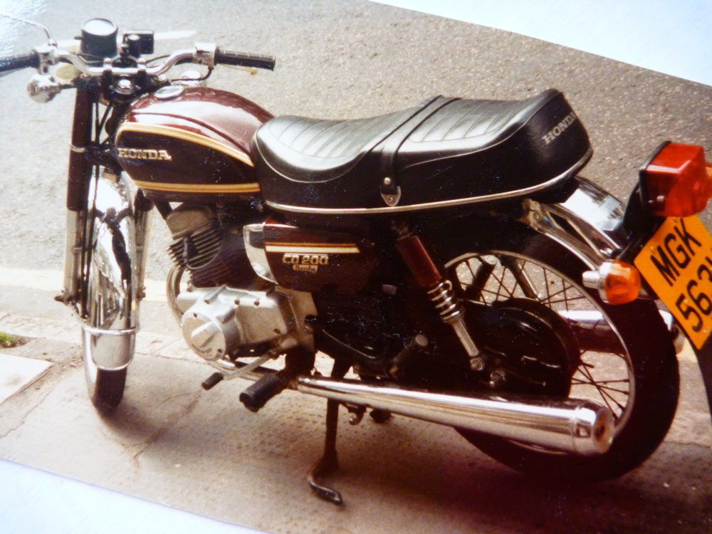
By 1984 I’d settled for an easy way of despatching for a living: working long but steady hours for a London typesetting outfit, delivering advertising copy on the one mile between Holborn and the West End. (You can read all about that and a whole lot more in The Street Riding Years.) There was no longer a need to ride an IT250 or a 900SS should you get sent to the other side of the country on a wet Friday evening. For this job a dreary commuter bike was sufficient. And none came drearier than Honda’s CD200 Benly twin (below left), a single-carbed commuter ridden by stoical Benlymen. Riding up to 12 hours a day on a hyper-dull CD can drive you a bit crazy at 24 years of age.
Honda CD200 Benly
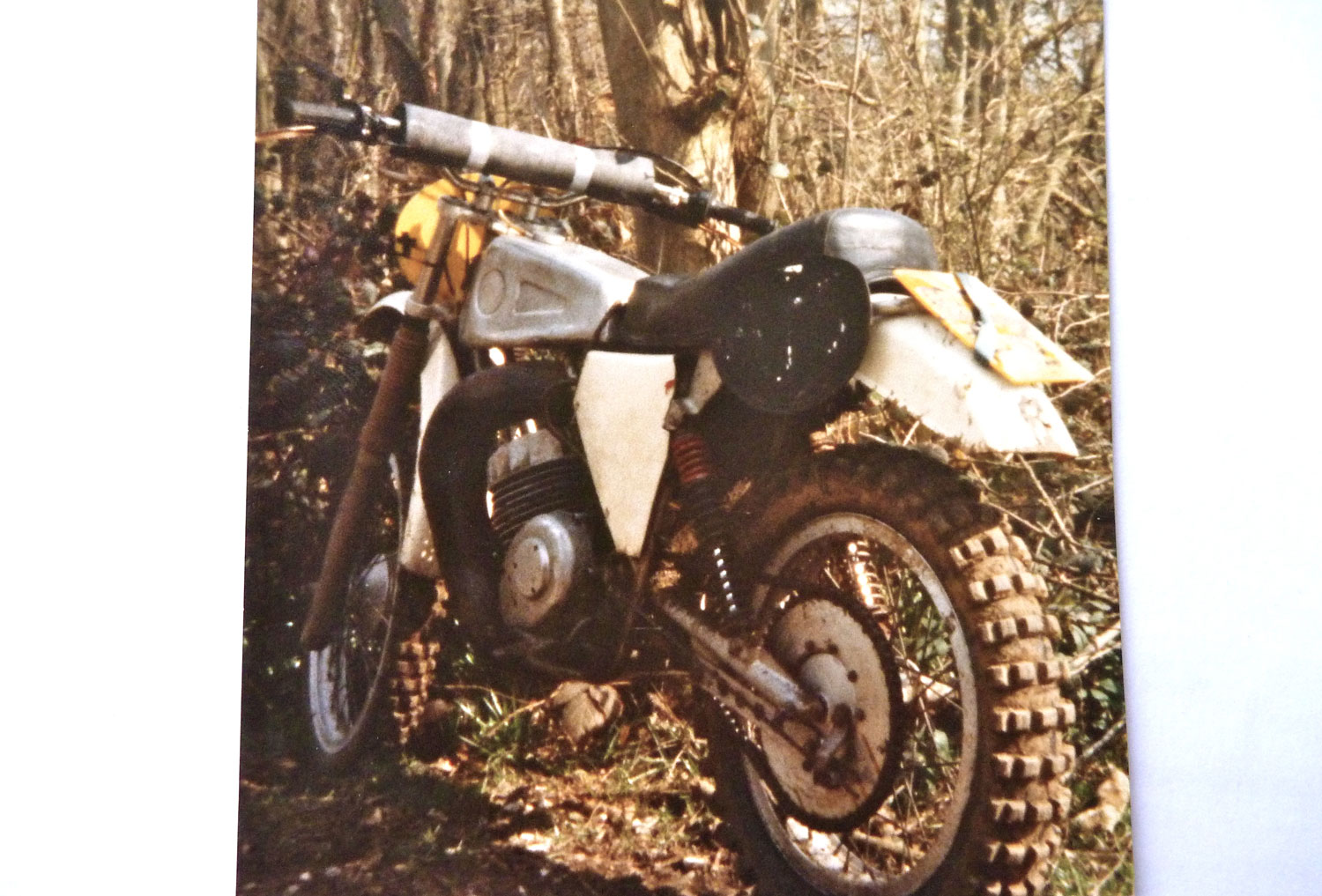
AJS Stormer 370
Knowing I was into dirt bikes, a mate put me on to a mate flogging an AJS 370 Stormer (right) for fifty quid. The Stormer was a vile, shin-kicking British two-stroke motocrosser that was the polar extreme of the Benly. In a flash of brilliance which years ago had given birth to the Triton cafe racer cult, I figured I could marry the two and make something more desert rideable and less boring: a Benly-engined, MX-framed desert racer!
Over the summer of 1984 the machine took shape in my artfully appointed bike design studio in London’s literary Bloomsbury district. It took two goes to get a bike shop to correct the engine alignment mistakes of the former. But here it was, suspended by some Honda XL250S shocks as long as truncheons, and silenced by VW Beetle tailpipes, a cunning, lightweight trick you may recall from the BMW I rode with in Algeria in 1982.
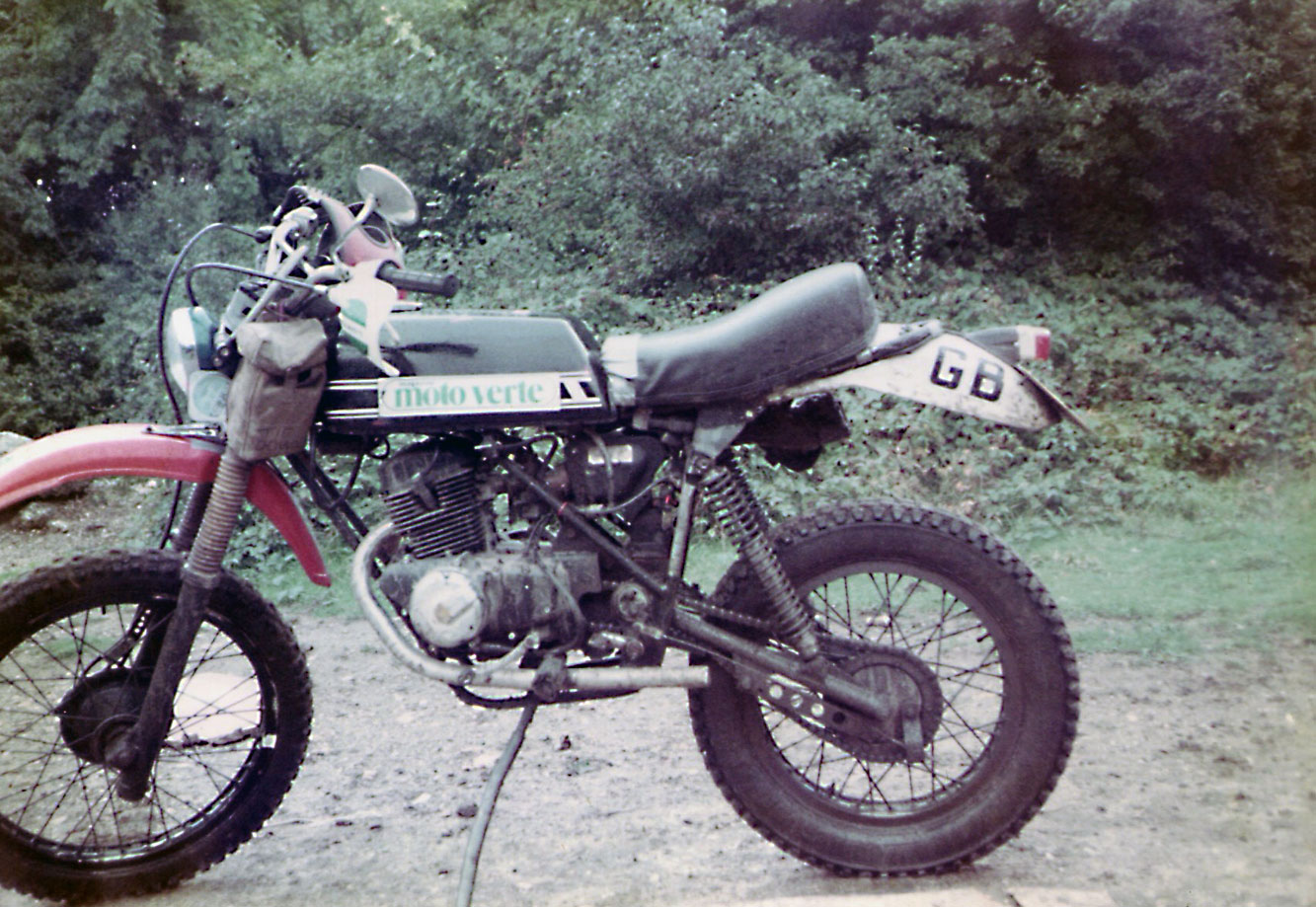
Later on, the job was finished off with gearing more suited to horizontal applications, and an RD250 tank with a sexy ‘Moto Verte’ sticker so there’d be no mistaking what an international, Franchophilious guy I was. I took it out to the woods near Addington to see what it could do. The answer was similar to dragging a dead dog around on a lead. The VW pipes reduced the power at the rear wheel to quite possibly single figures. The foot of clearance needed a running jump to get on the bike. And the AJS conical hub brakes where a requirement by the then powerful Ambulance Drivers’ Union to ensure their members were never without work scraping Stormer riders off the sides of buildings.
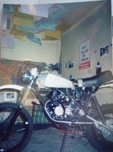
Testing the Benele
I dubbed the bike a ‘Bénélé‘ in envious recognition of Yamaha’s near-perfect XT600Z Ténéré which I’d spotted in a Sydney bike shop a year earlier, and which was itself based on Yamaha’s Dakar Rally desert racers. More about them, later.
So what do you do with a dumb-arsed desert racer? You ride it to the Sahara of course, in a little less time than was available. You pack a 3500-mile trip to North Africa into two-weeks and you schedule it for September when you imagine peak summer temperatures are on the wane. This time there’d be no fear of enduring the mid-winter transit of Europe and the northern Sahara, as in 1982.
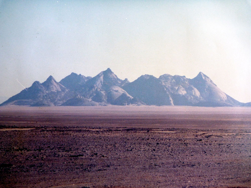
Sli Edrar – my destination in 1984 at 53mph
My goal that year was a mysterious massif of conical peaks which I’d passed by, south of Arak on my way to Tamanrasset in 1982 and which I’ve since learned is called Sli Edrar. The Bénélé’s top speed was no more than 53mph, and even at that speed it felt unsafe, should a squirrel run out in front of me. So to get a good run-up I rode straight from work on Friday night down to a mate’s in Canterbury, close to the port of Dover, ready to catch an early Dover ferry next morning.
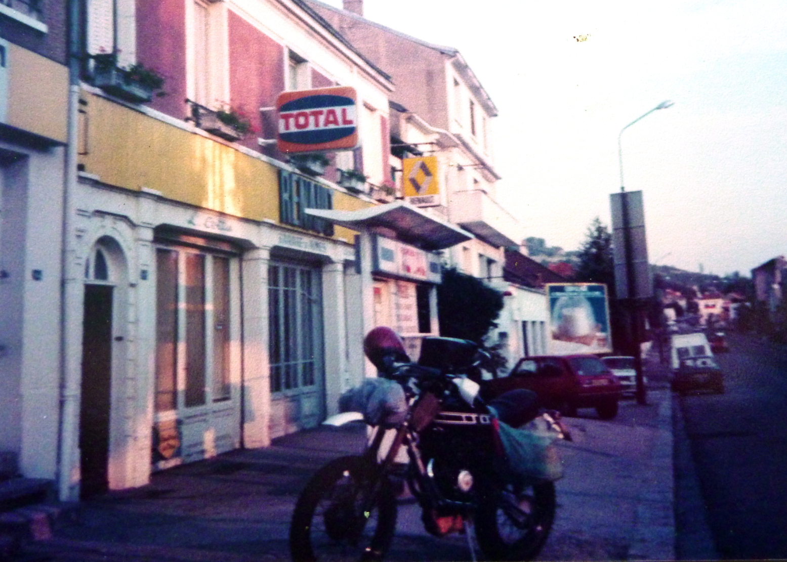
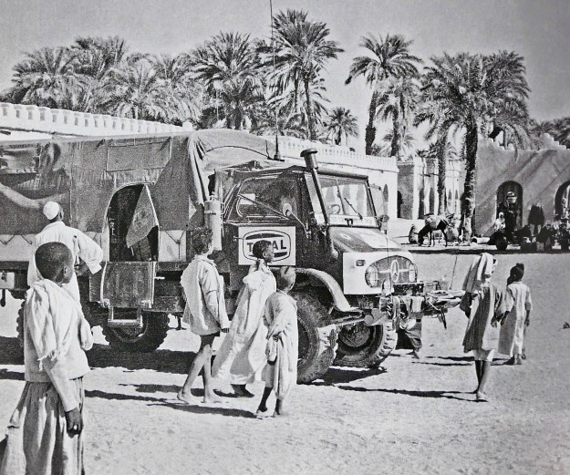
Total
Gumby
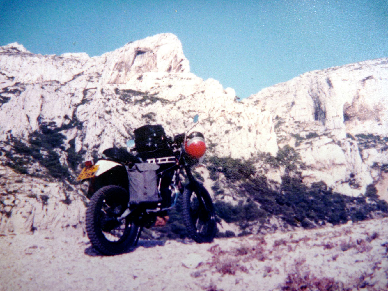
By maintaining momentum, Monday night found me camped back among the magical limestone outcrops of Cassis, near Marseille, ready to hop on the ferry to Algiers the following morning.
Cassis
Windsurfeurs, Marseille
You can see I had an all-new soft luggage set up. No more sawn-off chemical tins poorly lashed to Dexion racking. This time I had a small canvas pannier hanging on one side where a 10-litre jerrican slipped in; a thin cotton Times newspaper delivery bag dangling off the other with 10 litres of water, and an over-huge tank bag which sat on the flat-topped RD tank. A sleeping bag in front of the headlight – Easy Rider style – kept the bugs off the Benly headlight. Cunningly, I lashed a tool bag with other heavy items under the lofty engine. If my mass had been any more centralised I’d have become a Black Hole right there and then.
My first memory of Algeria that year was being a little unnerved that as far north as El Golea it was already 35°C by 9am. If you live in Yuma that’s probably no big deal in September, but for a South London boy it was a bit of a shock. I filled up in in town and set off across the Tademait plateau which had spooked me on my first transit in ’82. The town (or anything) was 400km away. I buzzed along at 9.8hp/hour and by early afternoon dust devils or mini tornadoes were whipping across the baking gibber to either side. I recalled how a mate said he’d been knocked off his XS650 by one in Turkey earlier that year.
I was already tired, thirsty, sore and hot when up ahead what looked like a huge wall of sand hundreds of feet high hurtled right across the blacktop. Only as I neared it did I realise it was the mother of all whirlwinds, a huge cauldron of rotating sand. I turned the wick up and and the motor droned as I punched the Benele into the sand wall. Inside, all visibility was lost as grains pelted me from all directions and I struggled to keep upright or even know which way it was. And then, as I slipped into the windless eye of the maelstrom, the sand grains briefly turned into pelting raindrops. WT jolly old F was going on!? Search me but before I knew it, I’d blasted out of the tornado’s far wall, this time shoved left onto the roadside gravel. Now I knew how those roadsigns got flattened into the dirt…
Just as in 1982, the Tademait had terrorised me and I vowed I’d ride into the dark to be off the plateau before stopping. I rode into the dusk, pulling up briefly with the engine running to remove the sleeping bag off the headlight, before pushing on into the big switchback descent from the Tademait to the desert floor.
That night I stripped off and lay in the dirt by the bike, listening to what sounded like the oil boiling in the crankcases, hours after switching off.
I wasn’t hungry but I drank and drank and soon fell asleep where I lay. Tomorrow I was heading past In Salah, the hottest town in Algeria, before heading deeper into the Sahara.
Half a century ago when the Sahara was more accessible, lateral crossings, all of them west to east, used to capture the imagination of adventurists, both private and corporate. Although such transits aren’t what it’s about to me, I wrote a box for the final edition of Sahara Overlandabout the four best-known vehicular transits which, broadly speaking, set out with this goal in mind, and expand on this page:
As I suggested in the book, a true, unbroken, all-desert lateral crossing of the Sahara with vehicles had yet to be achieved and as things stand, never will be in our time. If you combined the British route across Mauritania and Mali, then follow the French or Germans to Dirkou in Niger and the French or Belgians east of there, you have a pretty good line. As it is, even with a lot of road-driving in Algeria, I’d say from Tan Tan 9000km east to Port Safaga near Hurghada on the Red Sea, the Belgies get the nod (map below but note the oddly misaligned borders, not least Niger-Chad).
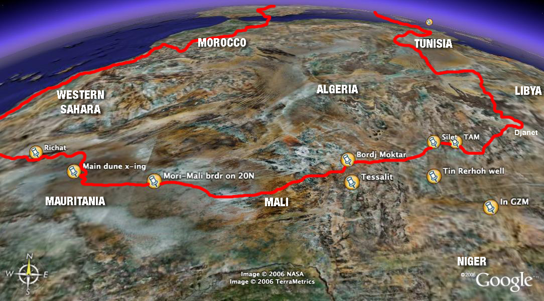
The chances of achieving a true Saharan traverse are currently about as slim as they’ve ever been. Much of the Sahara of Mali, southern Libya, northern Niger and Egypt are unsafe or off-limits. Eastern Far western Mauritania is said to be the same, and much of southern Algeria between Bordj east towards Djanet (as we did in 2006) is now restricted.
Unimog in Faya, 1965
Northern Chad always presented difficulties from the mountainous terrain, let alone permissions and security issues. Meanwhile, people smuggling convoys still roll into Libya across northern Sudan above Darfur and are preyed on by bandits.
One Hanomag burned out in the Gilf or thereabouts.
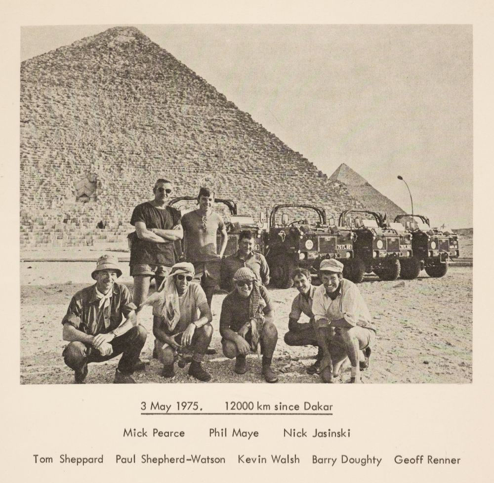
JSE 1975 route
In southern Egypt the Gilf has so many access regulations that few bother any more. Even in the west-east expedition era, permissions heavily restricted access: the Belgians had to enter Algeria from Spanish Sahara, not Morocco; the Brits couldn’t enter Algeria at all which kiboshed their plans and they went via Nigeria (left). Meanwhile the Hanomagers bounced for over 16,000km between the Maghreb and the Sahel like pinballs, but did a whole lot of classic desert routes; and the French seemed to dodge Algeria and Chad.
British Joint Services 101s in Sudan, 1975. More here
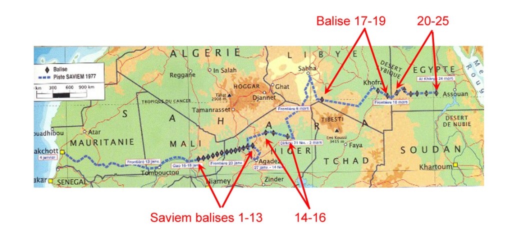
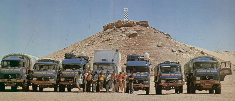
The Saviems of 1997 made a pretty good job of it once they left Mali, planting at least 25 of their distinctive blue and white balises across the desert is a bid to establish a new lateral trade route across the width of the Sahara. The value of that is clearly rather dubious, but it was a good excuse to promote the lorries and have a big Sahara nadventure, using trials bikes and even parascenders to help recce the route ahead.
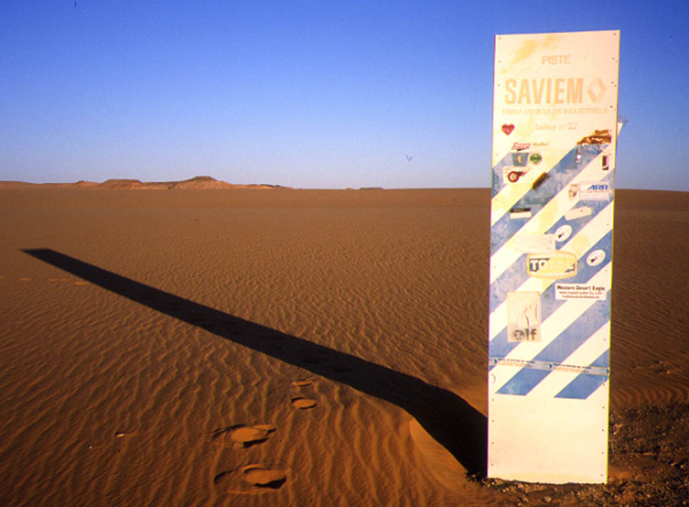
In my travels I’ve come across remnants of Saviem #16 in Niger, as well as an intact Saviem #22 east of the Gilf Kebir (below). And there’s a photo here of Saviem #10 just a couple of years after it was installed.
Saviem balise #22 in Egypt’s Libyan DesertSaviem TP3 vans and SM8 trucks spinning down in southern Egypt, 1977, below the final balise #25, somewhere south of Kharga on the Darb el Arbain around here.
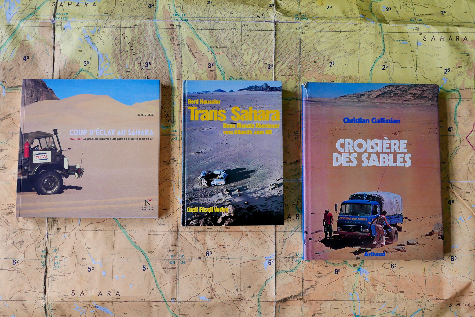
Of the four expeditions mentioned here, the three continental ones produced illustrated books in French and German (below). If you don’t read either language any better than me, the big-format Croisiere des Sables is a good one to get – mostly pictures and under a tenner on abebooks last time I looked.
Coup d’Eclat au Sahara, Jean Stasse (2011, available new) Trans Sahara – vom Atlantik zum Nil, Gerd Heussler (1978) Croisiere des Sables, Christian Gallissian (1977)
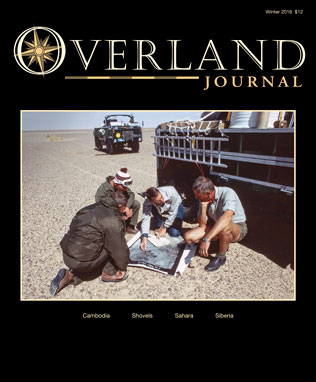
Even though Tom Sheppard has published a couple of lavish Sahara picture books on his own travels, it looks like we’ll never get a full account of the JSE 101 crossing (but see below). There was an appropriately dry expedition report for the Geographical Journal in 1976 which you can read on JSTOR (map below).
Tom Sheppard also wrote a well illustrated summary in the winter 2016 issue of Overland Journal (right). In 2022 I received an email from a reader who’d just acquired the full and exceedingly rare 150-page report which was being auctioned here. Looking further, it seems there may be a hard copy at the National Archives in Kew, too. Watch an interview with Tom here.
My own lateral crossings
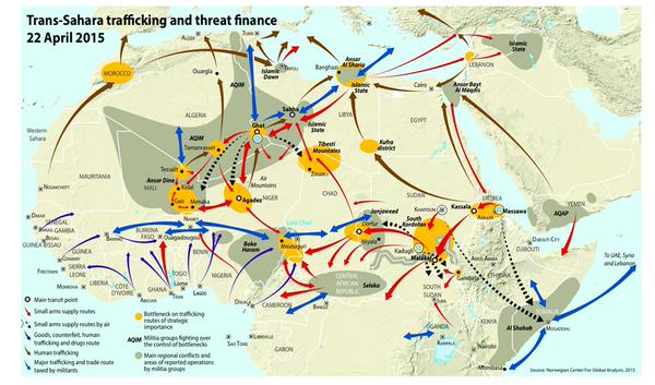
A while back, before things really got bad in the Sahara (right) it occurred to me that, with one small effort I could link up my own lateral crossing of the Sahara between the Nile and Atlantic. Of course it would have taken me several years, but mainly across three trips: Libya 1998 (researchingSahara Overland);Egypt 2004 and our big SEQ 2006 crossing (below) I’ve covered all bar around 800km of the distance.
Part of my informal west -east crossing
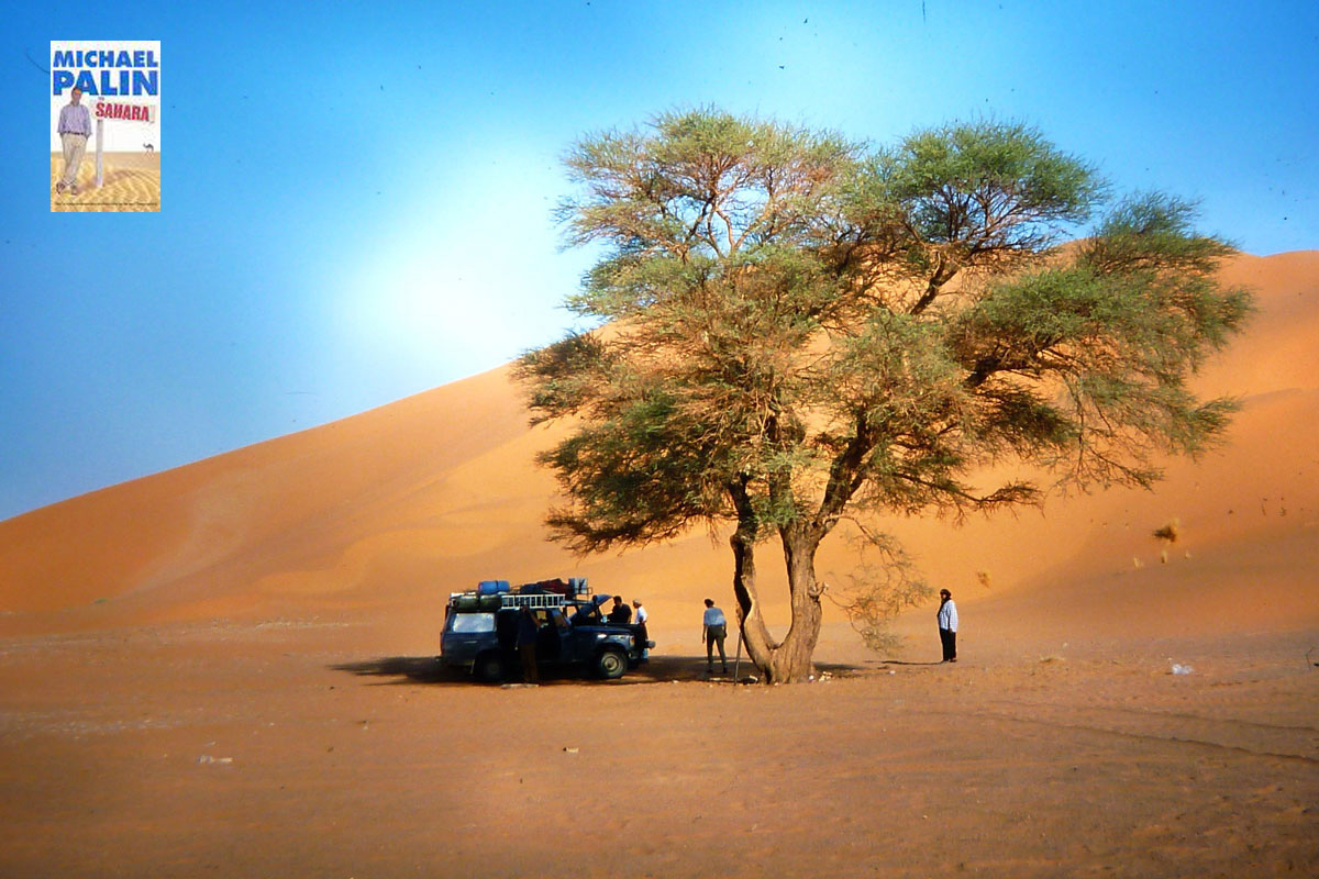
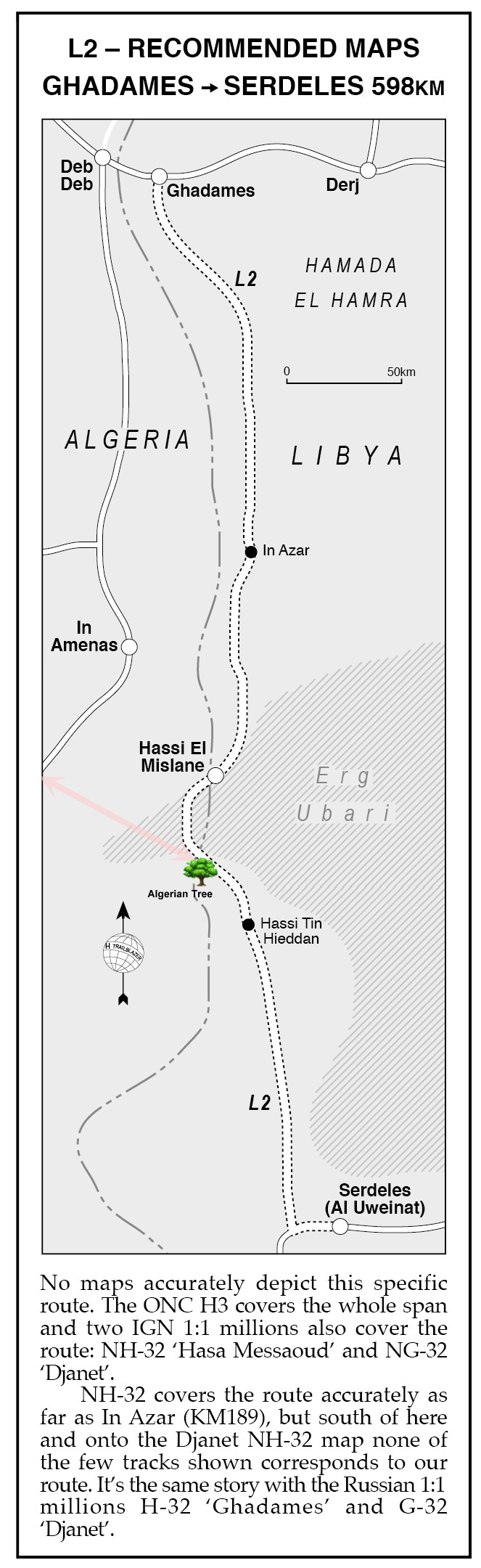
All that remained was a short, 70-km gap in the far eastern Algerian oilfields near In Amenas to the Algerian Tree (visible on Google sat and pictured left in 1998). It was whereRoute L2 from Sahara Overland (below right) strayed briefly into Algerian territory to avoid the worst of the Idehan Ubari’s dunes. Some may recall Michael Palin visited this very tree for his Sahara TV show in 2002 and on arriving proclaimed:
‘this spare, uncluttered, beautiful spot was one of my favourite places in the Sahara‘. Well, he’s easy to please!
And in fact, I’ve since realised that when we treked with mules to Sefar on the Tassili plateau in 2013, I was within sight our 1998 route into the Libyan Akakus.
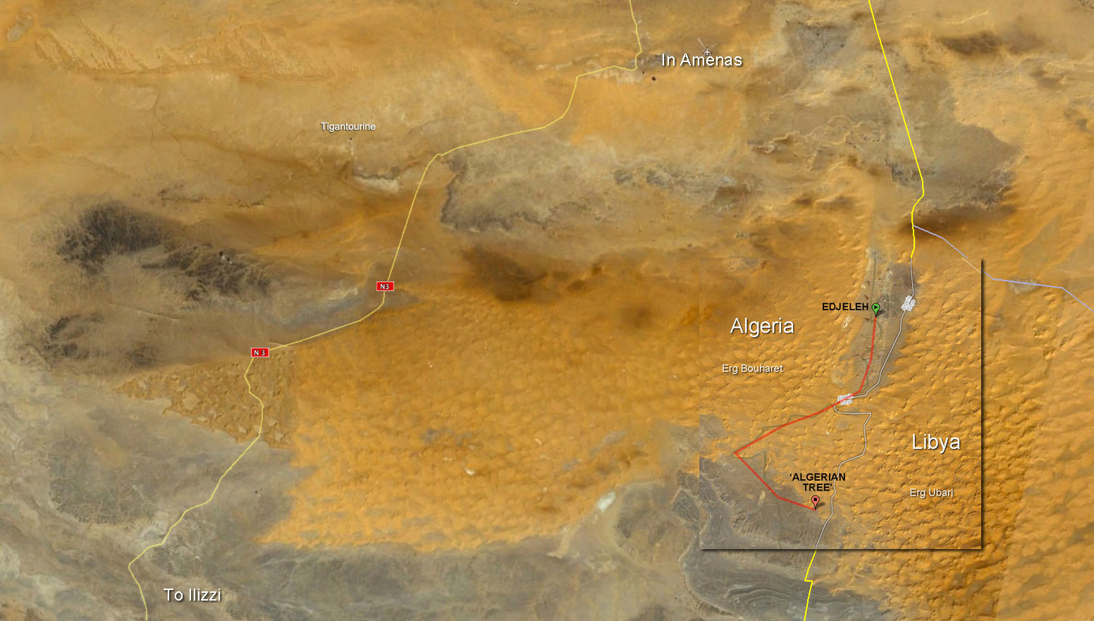
Up until the gas plant attack at Tigantourine that year, I could probably have knocked out my crossing to the Algerian Tree at any time. Either driving down to Edjeleh oil camp right on the Libyan border then scooting over the dunes as shown below).
I recall making contact with an oil worker based in Edjejeh one time, asking him about civilian access in the area but he wasn’t very forthcoming. Alternatively, one could just nail it 100km east from the N3 highway south of Erg Bourharet. The stony reg thereabouts is criss-crossed with oil exploration tracks, but, post-Tigantourine that area will now be closely watched.
Then there’s a much more substantial missing section to get my West-East certificate in eastern Libya: from Waw Namus crater which we visited in 1998 (below) …
I remember that Christmas well; we had more trouble than normal getting Mahmoud’s Toyota-engined Series III running, dragging it to life with the Land Cruiser (below) after setting a fire under the chilled engine. With us that time was Toby Savage (my Desert Driving dvd co-presenter) who in 2012 travelled through the Gilf with WWII-era Jeeps, while possibly outnumbered by escorts and soldiers.
Staaaart you bastard!
No tourist has driven in southern Libya since the fall of Gaddafi in 2011. The south was now controlled by the Tuareg (with a bit of AQIM and IS) and the Tubu who battle it out for the control of lucrative people-trafficking and other commodities coming up from Niger. As things stand now in Libya, ticking off that final 720-km stage from Waw crater to Xmas Camp may have to wait for a rainy day in the Sahara.
I was back in Tamanrasset, this time with a small group of camel trekkers. Year by year it gets more difficult to travel out here and a few weeks earlier Algeria cancelled all tourist visas to the desert– most probably due to weapons slipping out of Libya west towards Mali where some kind of rebellion has already broken out. As a result three missed out and only 7 got visas: 3 Americans: Diane and Steve from Tucson and Patrick from NYC, plus Rob from Bermuda, Hannah from Alderney, Rob from Bristol and Mike from Staffs who’d been on a 2006 Gilf trip I’d led for a tour agency. Right: Camel trekking ebook.
It’s nice to drive cars and ride bikes in the desert, but these days that can feel rather conspicuous as you come down from the north. With camels you slip into Tam on the midnight plane and 24 hours later are out in the sticks, largely unnoticed. Any anxieties I had about the ‘Grand Sud’ being closed and us getting stuck, or sent back from Tam came to nothing. And I knew once we were out bush all would be fine.
I’d originally planned a meaty 4-week trek from Tam to Djanet, but decided that left us exposed along the Niger border where an Italian woman had been grabbed a year ago. At the time she was one of 12 Europeans (as well as local police and others) in the hands of AQIM in north Mali. I’ve just started reading this book about the history behind these events and if nothing else, it underlines how dire it would to be dragged around the oueds of northern Mali for months at a time, suffering injuries and other ailments, with no shelter, terrible food and dirty water.
So, with Tam-Djanet a bit sketchy, the plan boiled down to repeating the reliable Amguid Crater trek I’d done a couple of times over the years for Simoon Travel, then drive back down to the Hoggar and spend a week walking up to Assekrem and back (report on that here). I was using a new agency, Ben Kada, now long gone but back then an established operator recommended by a friend of a friend. And so, along with all the other unknowns, I was hoping they were going to deliver, which in the end they did better than I’d expected. Last November a fake guide who’d infiltrated a well-known agency in Tam to set up a kidnap had been caught, so it’s hard not to be a little paranoid these days, even if the Algerian security services are on it.
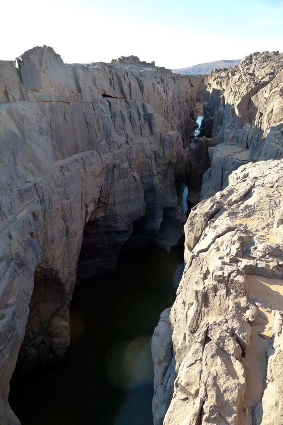
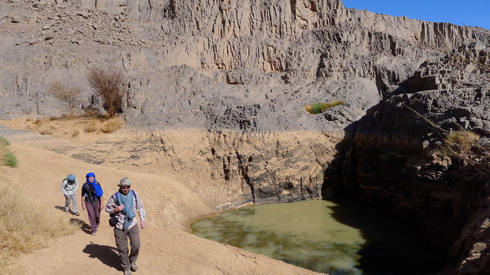
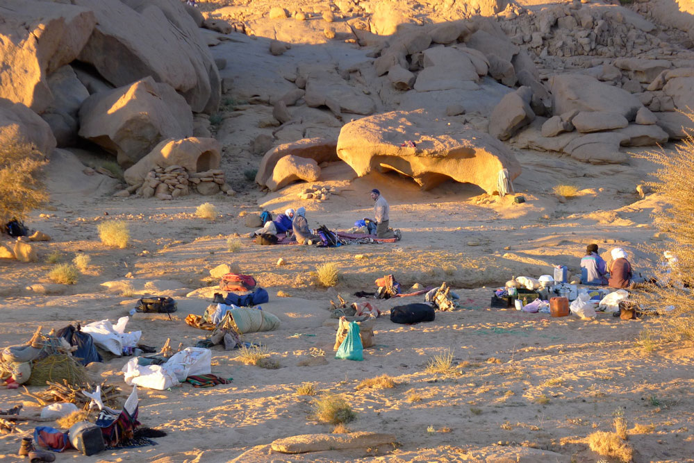
Next evening we arrived at the same camp south of Arak (left) which we’d used on the recce tour in 2007 with Simoon. The first day kicked off a stiff climb around midday which had been tough on the fully loaded camels, but this time our caravan managed fine. New Year’s Day followed, a spectacular amble through the box canyons of Tissadout, with lunch under a lone tree, a guelta swim and a rock art cave all ending at a great camp spot in the Adjror valley (home of Beetle guelta; these names established on the 2007 recce). Here we met the only other tourists in Algeria who were taking a two-weeker out of Arak. There followed a long haul to Igharghar valley, past the Haribo Tree, the Lunch Cave and the desert mosque, before diverting to a deep slot canyon and tombs which I’d missed on previous visits. Interestingly the deep cleft (above) is actually the river which breaks out through the gap in the ranges at Tadjemout, where we’ve started the tour on previous occasions. Once at camp I got rather lost in the dark while looking for firewood, returning to the camp from the opposite direction, but no one seemed to notice.
Next day I asked to Mohamed, our genial 72-year old guide, to visit the impressive three-tiered gueltas (rain-fed waterhole) we’d lunched at in 2007, but which had been skipped by subsequent guides. On the way there, Patrick lost us while engrossed in the manual of his new Nikon Tankbuster, but did the right thing by getting onto high ground and was back on our trail by the time Mohamed had backtracked to find him. The same had happened to me hereabouts a tour or two ago when I’d stopped off and ended up chasing half-burned toilet paper in the breeze. Now Patrick also knew that chilling feeling when you lose sight of the group, any trace of their tracks, and haven’t got a clue which way is up.
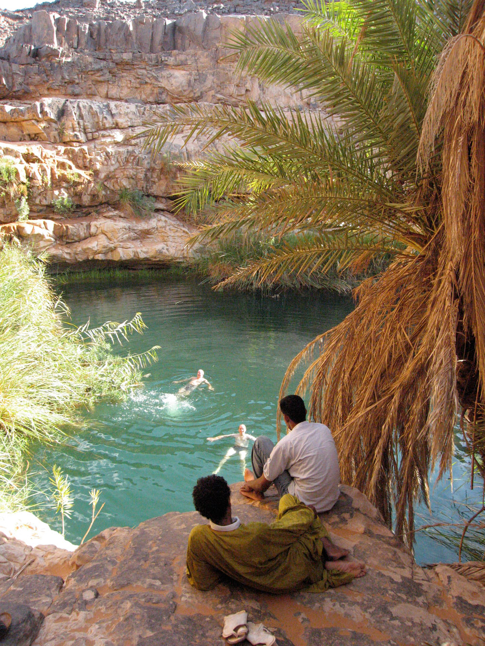
As it happens the many tiered gueltas of Tin Karabatine were very low on water – as were many other rock pools in the region this year, but we managed to launder and wash anyway, while Mohamed instructed us to follow the canyon’s right rim upstream for 30 minutes to meet him and Tayeb the cook with the lunch camel in the valley above. It seemed a bit of a leap of faith, but we passed the test and met up close to the ever-serendipitous acacia which crops up at these times. Later on Tayeb was similarly tested by Mohamed, with less success.
I knew well that the afternoon ahead was one of the nicest stages of the walk, made all the better by spotting a galloping mouflon (barbary sheep) as big as a donkey, as well as cheetah tracks (above), before we wound our way through the sandy outcrops down to woodless Camp IV. Next day was another long walk, 25km over to Tahaft; down into the big valley with a lazy lunch under a thorn-free tamarisk while the crew filled up from the soak. As on previous walks, we staggered in as the sun was setting behind us, but very soon Tayeb had the tea and biscuits laid out while we waited for dinner. Up till that day, as with all that followed, there was very little wind until maybe the late afternoon which kept things warm, though it dropped to near-freezing most nights, and sometimes below.
Even with a waypoint, I blundered around next morning to locate our discrete 100KM marker from 2007, until Diane spotted it and we lined up for the now traditional photo (left).
Us at 100 kilo cairn
Mohamed diverted soon after to chat up a couple of bedraggled goat nomads about pasture and water up ahead. He’d been here once in the last 25 years if I understood him correctly, but knew all the spots and was still showing me new places and routes, even on my fourth visit here. After a splash in the Tahaft slot-guelta and another lazy lunch, Mohamed led us on a great cross-country scramble down to the ‘lost oasis’ of Tin Djerane where birds twittered and jackal tracks set hard in the mud.
Abandoned In Djerane oasis
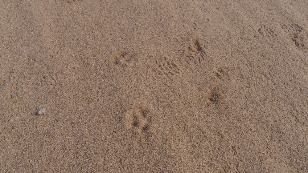
We heard their yelps on a few nights, but I’ve never actually seen one out in the desert. Along the camel trails you’ll regularly find stone slabs laid up into conical ‘goat holders’ to protect them from overnight jackals.
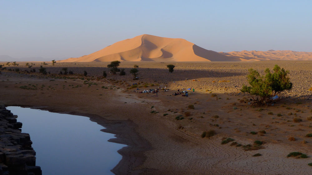
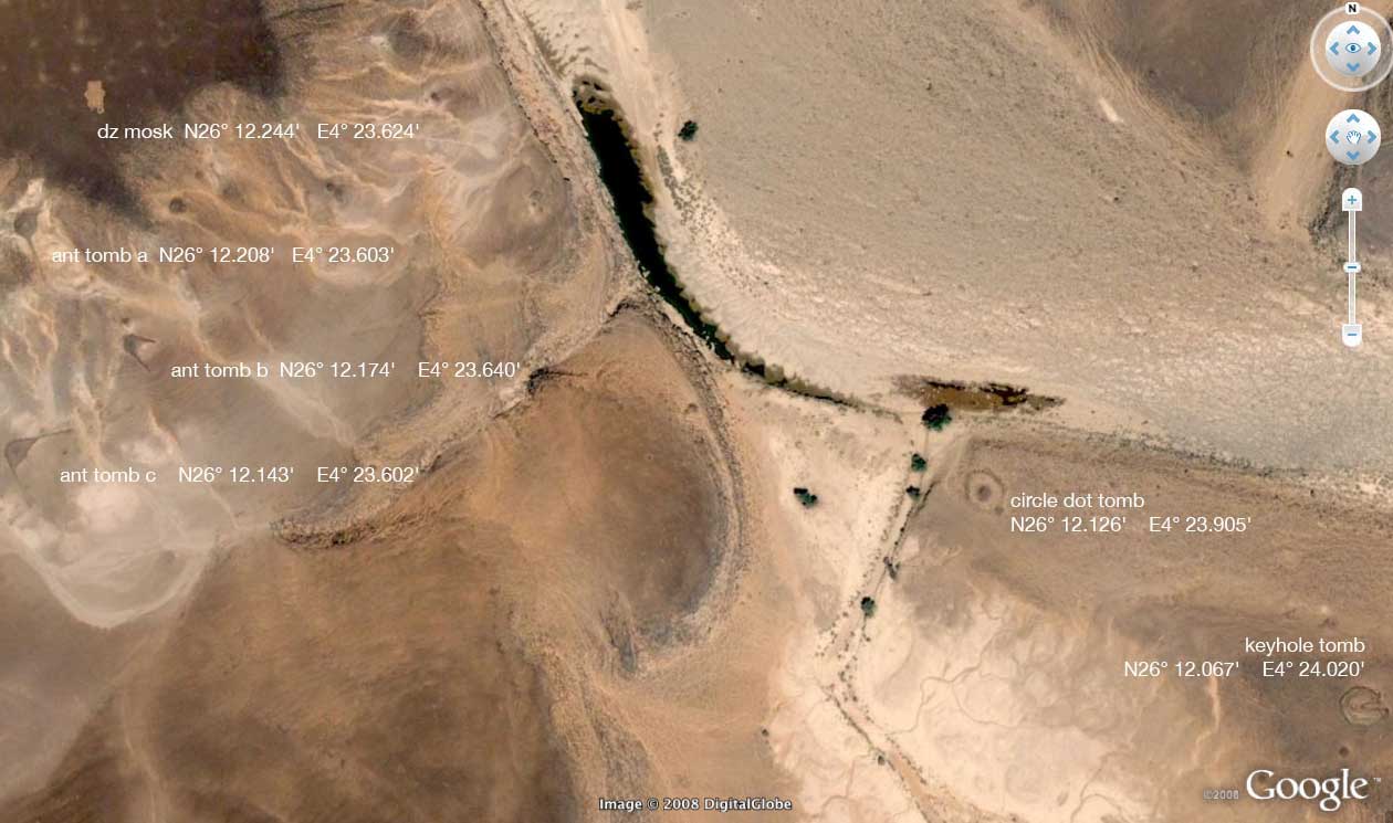
Huge keyhole tomb
More sparkling gueltas and even flower-clad lawns led to Camel Branding Camp V along the south edge of the Tissadert escarpment. This place is surrounded by ancient tombs, many of which had been annotated on Google Earth by ‘Ken Grok’ before Google erased the layer. There’s a ‘keyhole tomb’ a couple of minutes from camp (above), another 700 metres away which we passed close by later, but the strikingly huge antenna tomb I led us to with the GPS (below) was so big it was hard to visualise at ground level.
Antenna tomb
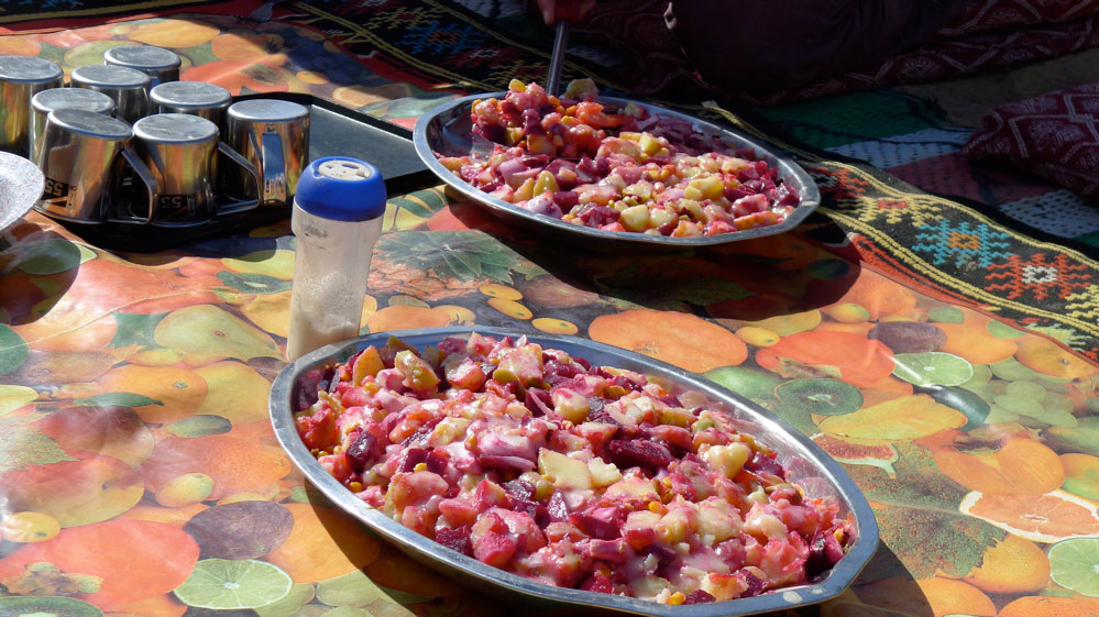
Following another swim at a big guelta, we failed to meet up with Tayeb and the lunch camel. Tayeb was from Tazrouk down in the Hoggar and this was his first visit to the Immidir which Mohamed and his aged crew, Halil and Ahmed, knew well. So it was a bit of a reach asking him to meet us up ahead in a creek he’d never seen. We zig-zagged around while Mohamed tried to pick up the trail and at one point I strolled right across another huge keyhole tomb. Eventually Mohamed found fresh tracks and around 3pm we spotted Tayeb sat patiently alongside an acacia-lined oued. Ravenous by now, he got an unfair bollocking while we tucked into the heaped platters of salad which Tayeb prepared for us daily.
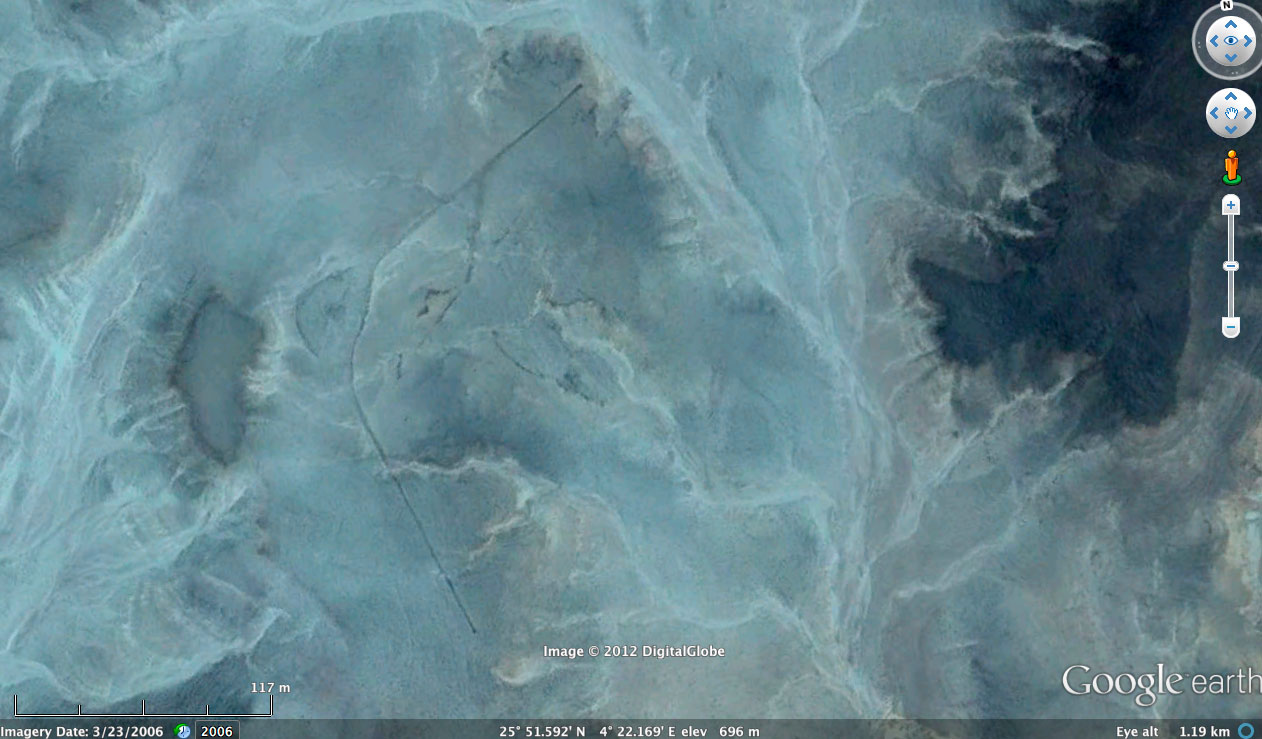
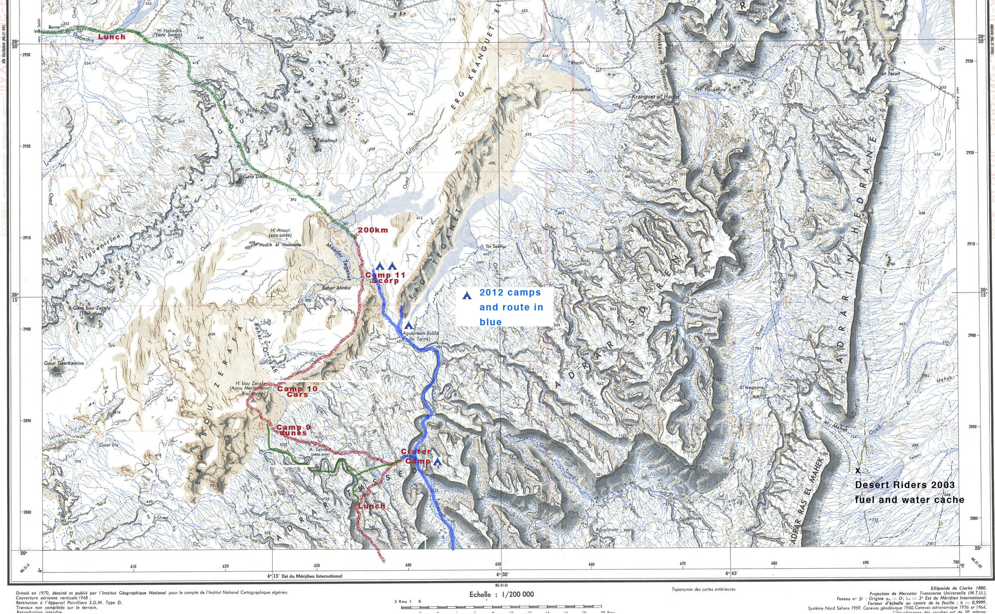
Mohamed had suggested that to get to the crater we take the next oued east after Tissadert, the Oued Taferekrak (according to the IGN map, below). Approaching the crater from this side was something I’d wanted to try for a while as the site lies just 500 metres from the canyon rim and ends up at the interesting Aguelman Rahla, surrounded by more pre-islamic tombs as well as dunes.
This also happened to be along the approach route to the crater we’d planned on Desert Riders back in 2003, going as far as leaving a fuel and water cache at Foum el Mahek gap to the east a year earlier (see map above). That trip did not end so well, but having now walked up it, I’m not so sure riding the lardy Honda XRLs would have been at all easy up here.
After a light overnight freeze, we set off up the wide canyon (above) and as expected, met some goat nomads who agreed to sell us an animal for a hefty €75. It had been the same price last year, but down in the Hoggar I was later quoted €50. Still, for a tenner each we ate well for three days and the crew got an unexpected treat too.
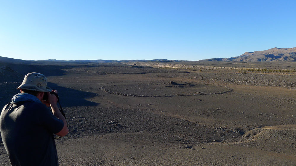
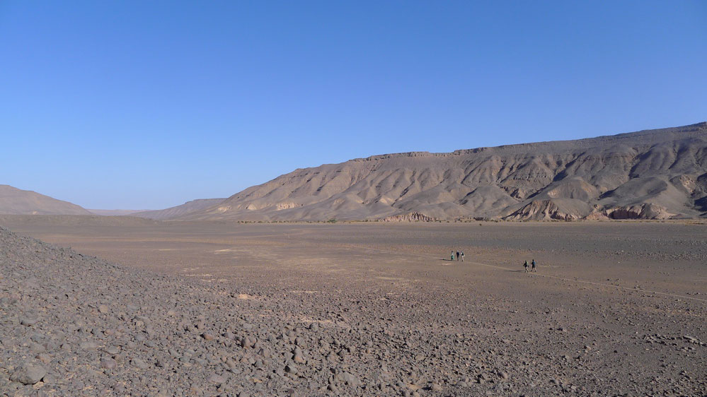
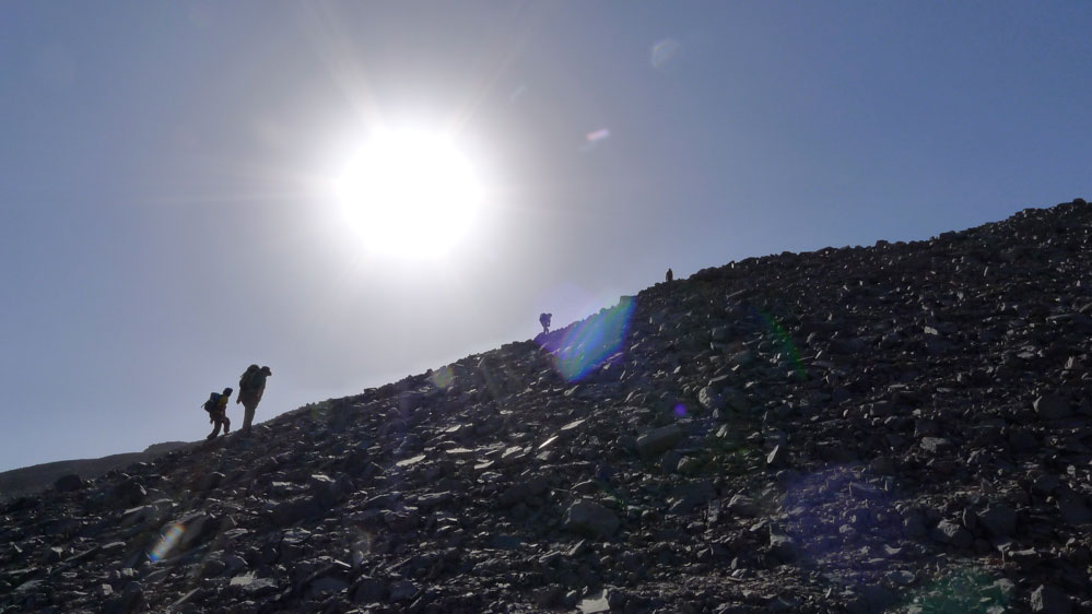
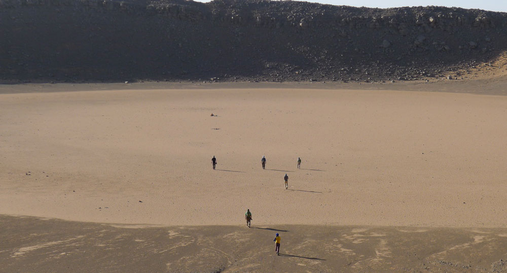
So, while the old men and Tayeb prepared to chop up the goat, we set off for the crater up the steep canyonside (above) with Salah, Mohamed’s 18-year-old son. After just an hour of huffing and puffing we looked down onto the crater (below), since sullied with stone-stencilled graffiti.
Some, including myself, thought it should be obliterated to return the crater to its natural form, but as some of it was clearly the work of Algerians from Ghardaia, others argued that, as foreigners, it was not our place to be meddling with locals wanting to lift their leg on the place. And at least the loose stones were not permanent. Maybe someone else will do the right thing.
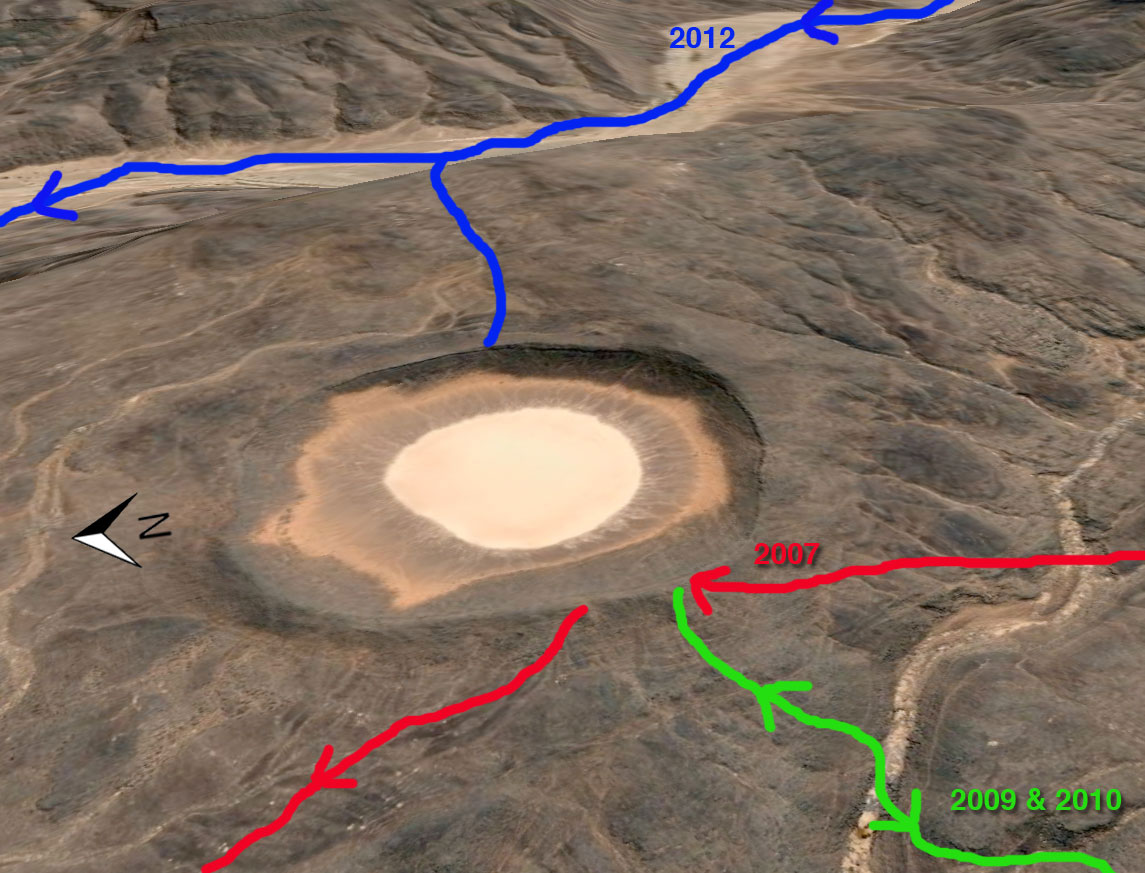
The various ways we approach the crater over the years
A dust haze had drifted up the valley that day, reminding me of the near disaster (from a visibility PoV) we’d had on the Eclipse tour in Niger back in 2006. Undeterred, Salah leapt back down to the canyon floor like a rubber gazelle where sure enough, a fresh goat stew was bubbling on the coals.
Aguelmam Rahla
The following day we emerged from the Tafrakerk canyon at Aguelmam Rahla guelta (above) where we were in a little too much of a rush to wash off the dust of several days, much to the displeasure of Mohamed. He was quite right, we should have filled up and taken a bucket elsewhere, this waterhole is a key point for nomads topping off their goats prior to collection by Arab traders coming in from In Salah, two days drive northwest. A mile away, the terminal dune of the Erg Teganet (above) made a great backdrop to our camp as well as a challenge for some next morning, while I wandered around looking for the tombs I recalled seeing clearly on Google Earth a while back (below). More on tombs here.
After lunch we continued for half a day up the sandy Teganet oued in the direction of Bir Outene at around 200km. Here we had a day off waiting for the cars to arrive, as we’d saved a day taking the new route to the crater.
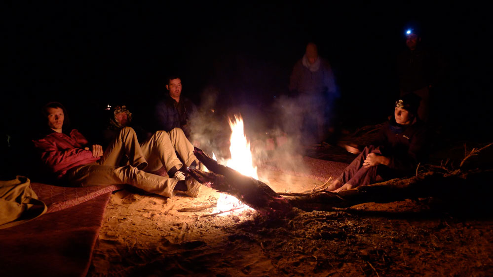
We sat around, moving with the shade while reading our books or Kindles until the late afternoon brought the distinctive hum of 4x4s churning up the river bed in low range. Too late to pack up now, one of the drivers had a guitar and later that evening around the fire we listened to him and Mohamed drumming on a plastic water can. Then, as the sands sucked in the cold we headed for our dispersed camps. It was an early start next morning for the long run to Mehajibat dunes and another day’s drive down the TSH to our Hoggar base camp. More about that here.
Since then, I’ve asked many times but am told the Immidir region is closed to tourism – as it the better known Tassili Hoggar region southeast of Tam. The only reason I can think is that Tamanrasset authorities would rather corral tourists around Assekrem, though that didn’t stop one getting kidnapped near there in 2025. The Immidir is inaccessible by car.
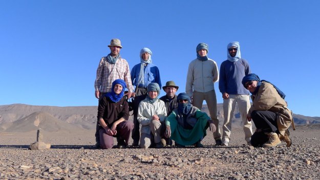
From the back: me, RobUK, Patrick, Steve, Sharif, Mohamed, Halil, Salah, Ahmed, Rob, Mike, Hannah, Diane, Tayeb, Loukmane, Said.
Immidir practicalities Tam-based Ben Kada agency had never run- or probably even heard of the crater route before, so I presume they took it upon themselves to track down Mohamed and his crew and ascertain that they could lay on the gear and knew the way. Ben Kada drivers dropped us off with the caravan and picked us up 11 days later, leaving it to the Arak guys to do the job.
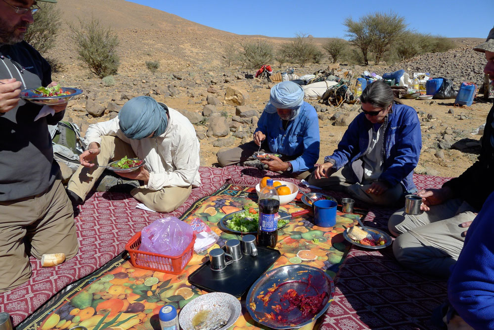
We breakfasted around 7.30am, just around dawn, and walked between 15 and 25km a day (10-15 miles), which was plenty given the terrain at times, although lunches were often 2 hours long. Most of the time we didn’t travel with the caravan and took detours which the camels did not follow. Sometimes we travelled with the kitchen camel and Tayeb the cook who prepared lunch, very often the best meal of the day. Breakfast was lean: tea or coffee, bread (baguettes or tagela ‘sand bread’), a solid block of marg, jam and Vache. As suggested beforehand, a couple BYO muesli or instant porridge. Once we had pancakes or French toast (eggy bread) or omelettes. Many carried day snacks, though I went without as I had some weight to shed but was pretty hungry at most meals. Hot drinks, peanuts and biscuits were laid out soon after we arrived at the camp – most welcome – and dinner was ready two hours later: soup followed by a muttony stew, sometimes with pasta or cous-cous or rice or bread, plus dates or oranges – and glasses of tea later. Most were asleep by 10pm.
Once water was taken from gueltas we filtered it, though we all agreed it was more to get rid of unsightly sediment than microbes which might make us ill. We drunk enough untreated water from other sources and no one got ill. The sediment makes filters clog up within a litre or two so the uncleanable ‘squeeze bottle’ type got blocked early on, while the cleanable Katadyn and MSR ceramic core jobbies carried on working with regular cleaning.
Most of us had small blisters by the end and could do nothing about them except plaster them and keep them clean. No one’s walking was really affected; I had a really raw small toe but that recovered well enough on the two-day drive to Hoggar. I had a feeling my feet swelled up after a few days which may have led to this – thinner socks did the trick until they wore out. Interestingly Bermuda Rob did the whole walk in a $70 pair of Nikes. They survived, were very comfy and he had no blisters! There were no other injuries even though we worked out there had been no less than four million opportunities to miss a step and sprain an ankle
Most found it got cold around 6am: the mats supplied were pretty thin but once I remembered we had them, the extra blankets laid on were a great help with warmth (under or over).
The cook spotted one small, harmless snake on the trail which he killed without thought. Some were surprised by this, but desert dwellers have a different attitude to these and scorpions (none seen).
Just uploaded the 20-minute section from Desert Driving II dvd in which Toby Savage and I describe how we set up our vehicles for long-range desert travel.
This was shot in 2002; no doubt gadgets have moved on since then but the principles remain the same.
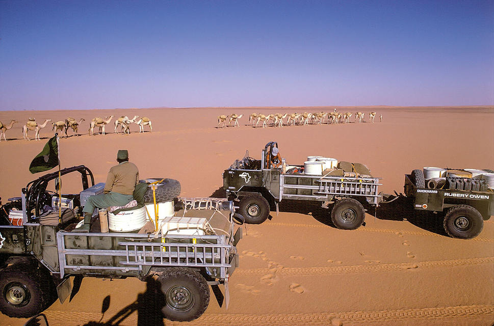
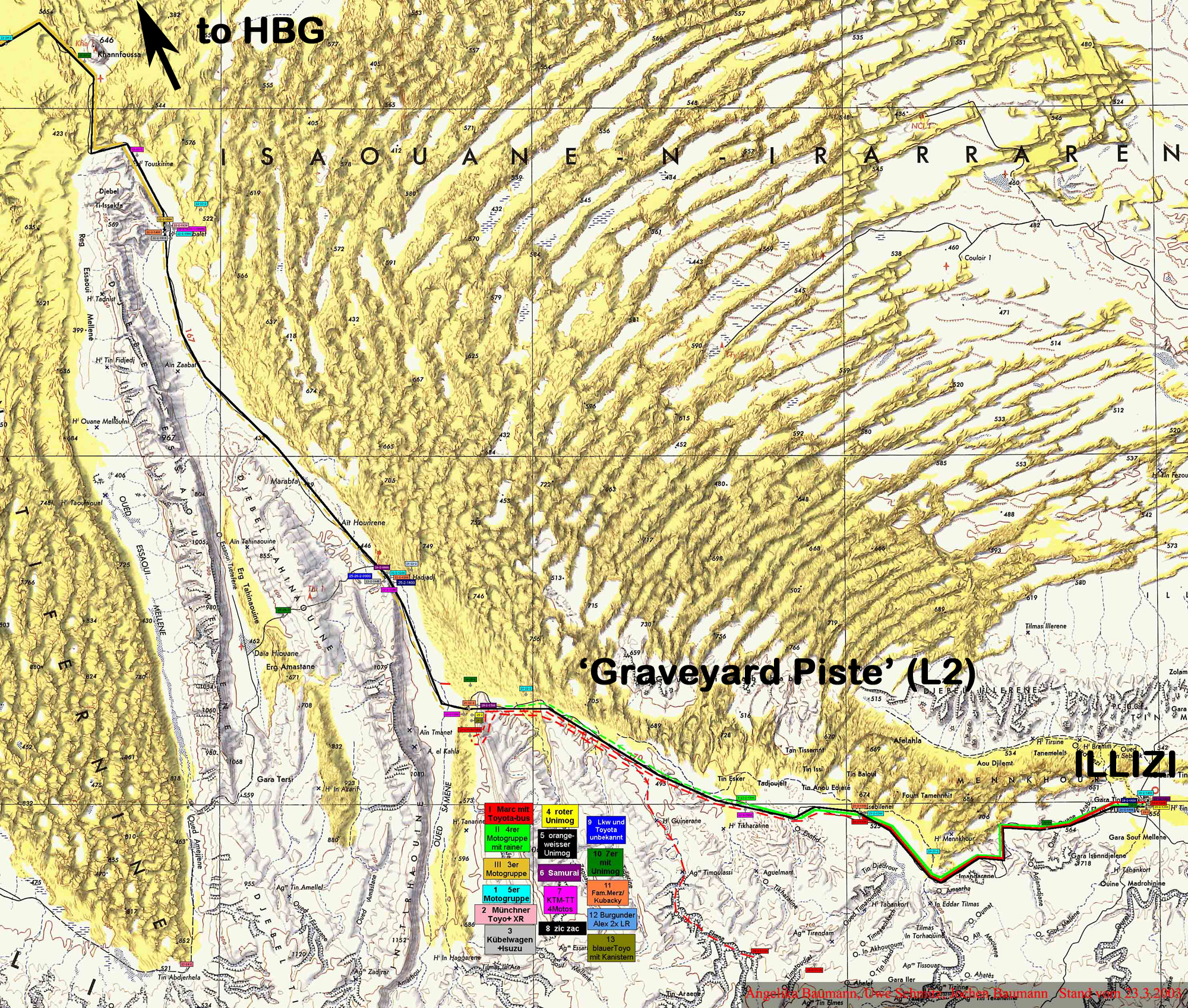
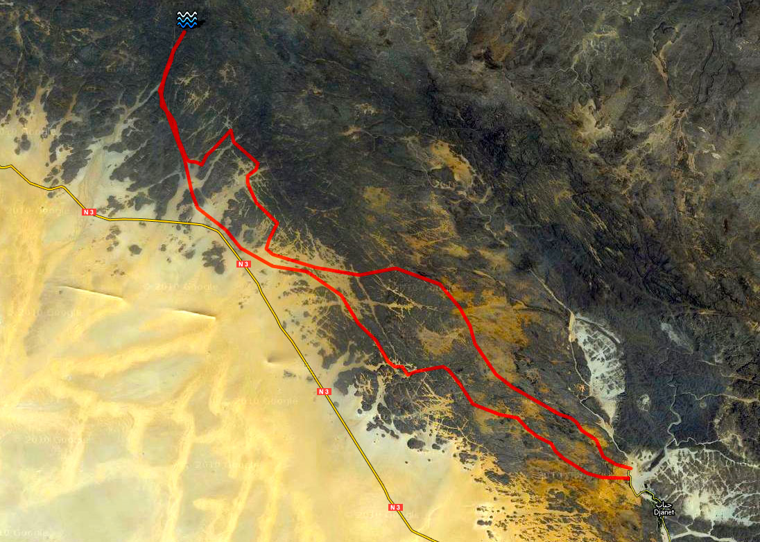
Before we met up to make the film I was travelling in the deep south of Algeria, burying fuel and food caches for Desert Riders which we did in early 2003.
With that done, we filmed the whole thing from Illizi to HbG in about 3 days along the so-called ‘Graveyard Piste’ (A2 in the book). It runs some 470-km between Illizi and Hassi bel Guebbour and adds up to the perfect Saharan piste: pre-historic graves, dunes, gazelles, plateaux, old French fort, a couple of wells as well as nomad camps – Sahara in a nut shell.
Just as we were coming back from D Riders, it was along this popular piste a few months later that 32 tourists on motos and 4x4s (some of whom we’d met in Tam) were kidnapped, kicking off the current situation in the Sahara. The scourge continues (two more kidnapped today in Mali) and it left a lot of desert-ready fourbies all dressed up and nowhere to go.
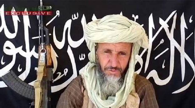
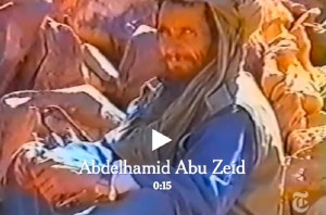
In early March 2013 AQIM confirmed that MBM rival Abu Zeid (left) was killed during the French Operation Serval in northern Mali. Full story here. Interestingly, the NYT video linked below shows the 4′ 9″ jihadist was involved in the 2003 abductions too (left). In 2015, and again in 2016, it was also reported that MBM had been killed by airstrikes in Libya. He no longer features on US wanted lists, but this article in 2017 suggests he’s still influential, while not spelling out if he’s actually alive.
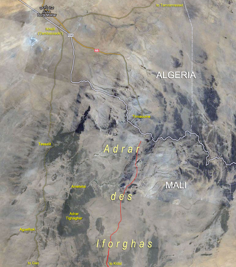
In March 2013, following weeks of ostensibly effortless liberations of north Malian towns while jihadists repeatedly slipped away into the desert to fight another day, the French-led Operation Serval concluded a decisive but protracted battle in the far north. At the time the Chadian army announced the death of the notorious Abou Zeid (‘ABZ’, left) in the valley of Ametetai (or Amettetaï) somewhere inthe Adrar des Ifoghas hills. It was confirmed by DNA tests a few weeks later.
The strategic significance of this obscure valley became clear when the assault began in mid-February. A huge effort was made to defend it during which time scores of militants as well as many Chadian soldiers were killed and huge caches of arms were found. A few days after Ametetai had been ostensibly cleared there was perhaps hasty talk by the French of drawing down their troops in April, while the French defence minister deemed it safe enough to make a surprise visit to the battle site a few days later.
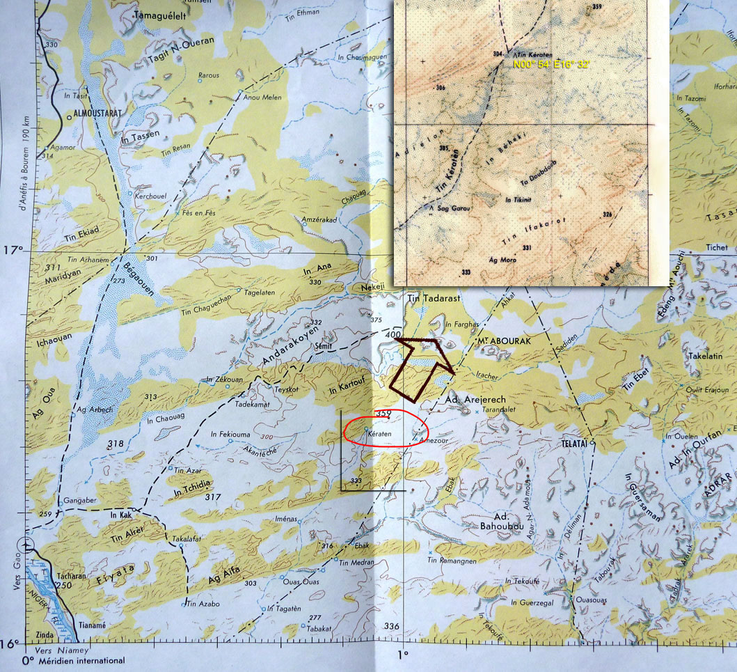
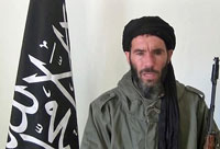
Just a day after ABZ’s death, Moktar Belmoktar (‘MBM’), supposedly ABZ’s rival and with him one of the three key jihadist ’emirs’ in north Mali at the time, was also (but incorrectly) reported killed by the Chadians. In fact the Pimpernel-like MBM had been ‘killed’ many times in the last decade or two (mostly recently in 2015 and 2016). In 2013 shot to Bin Laden-like prominence as the instigator of the suicidal attack on the Algerian gas plant at In Amenas. It’s more likely that at the time MBM (right) may have been directing AQIM operations further south, possibly in the region of Tin Keraten. Old maps label this as a well and a oued, some 100km northeast of Gao and 220km south of Kidal (see map above left). It doesn’t seem to match the terrain profile of Ametetai, but a battle was reported here a day or two later and where a fourth French soldier was killed. It’s also just as likely that before it’s all over MBM may yet again slip away into the neighbouring countries or that he was never there at all. The latest news is that following an ineffective US air strike in 2015, in November 2016 a French drone strike in southwest Libya injured MBM gravely. He has been removed from the American RFJ programme and has since lost his position in the Al-Mourabitoun group he led.
Abou Zeid
Real name Mohamed Ghadir, a small-time smuggler from Deb Deb in eastern Algeria close to the Libyan border (a book including his background reviewed here), Abou Zeid named his katiba or brigade ‘Tarek Ibn Ziyad’ after the 8th-century Moorish general who conquered Spain (‘Gibraltar’ is an anglicised version of Jebel Tarik). Following spells in prison, Abou Zeid rose up the ranks of the GSPC and became noted as a hardliner – ruling his group with ‘an iron fist’ as one former French hostage explained (her husband remains in captivity in north Mali). ABZ was said to be responsible for the execution of British-born hostage Edwin Dyer in 2009 (see link below) as well as more recent mutilations in Timbuktu in the name of Sharia laws. More on ABZ here.
Many news reports parroted the ‘Ametetai valley’ as the location of this decisive battle which led to ABZ’s death, though none mapped it any more precisely than this BBC image. Seeing as it’s rare to get a specific location of what you presume might have been a key jihadist stronghold where some of the ten or so hostages may be kept and where ABZ’s brigade made their last stand, I tracked Ametetai down. (Some reports also mentioned air raids on ‘Etagho’ or ‘Oued? Entouwike’, as the ‘key to unlocking the bases in Adrar Tighaghar’ massif, but again, no accurate location was given and I couldn’t track them down on the usual maps.)
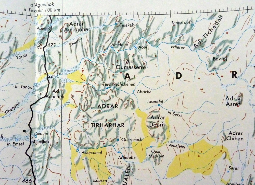
A well with the name ‘Ametetai’ was easily found on the IGN ‘Kidal’ NE-31 map (right), located on the northern edge of the Adrar Tighaghar hills and about 60km northeast of Aguelhok. Aguelhok is a village on the trans-Saharan Tanezrouft track which runs from Reggane, Algeria down to the Niger river and Gao (Route B1 in Sahara Overland).
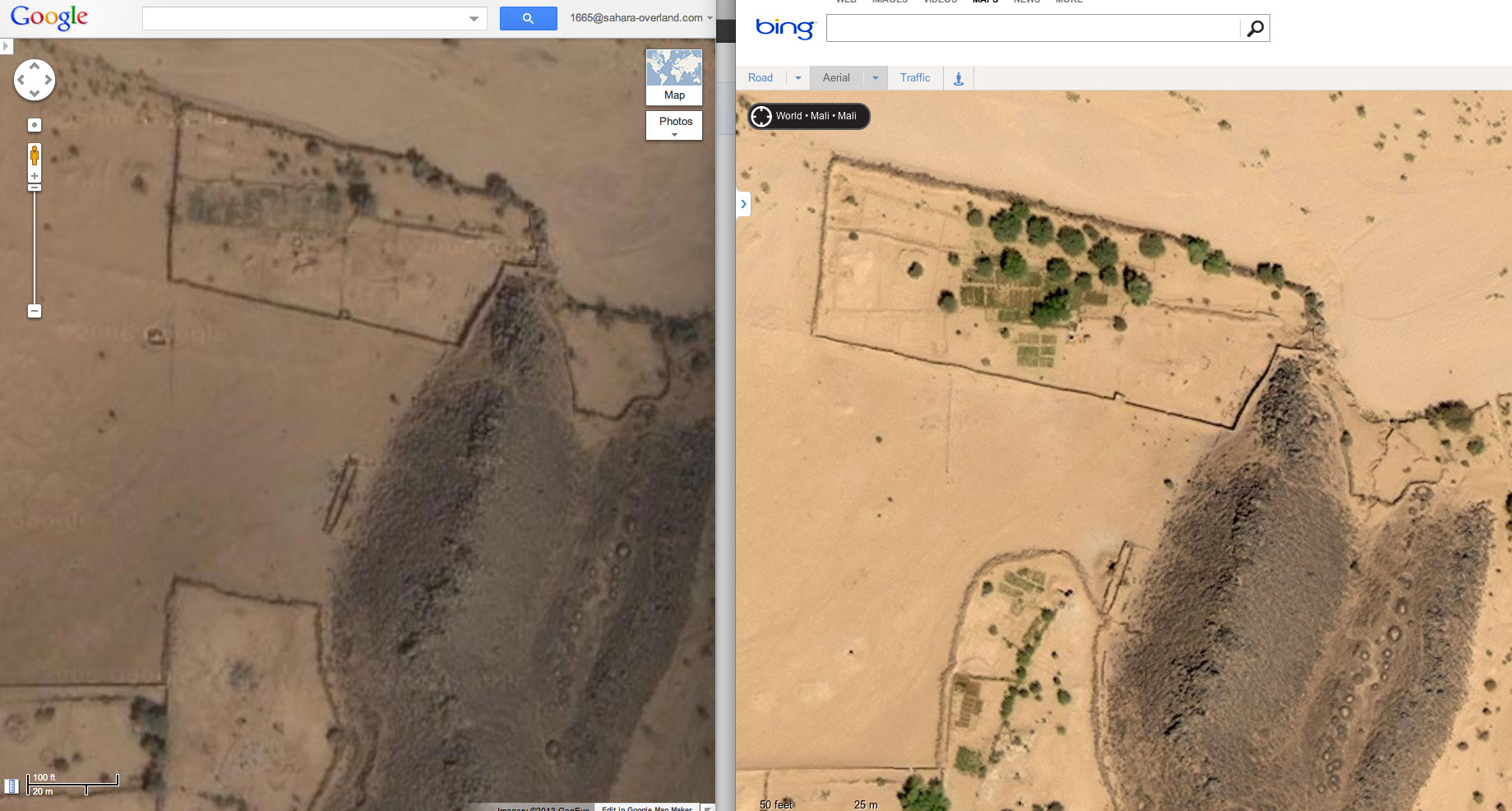
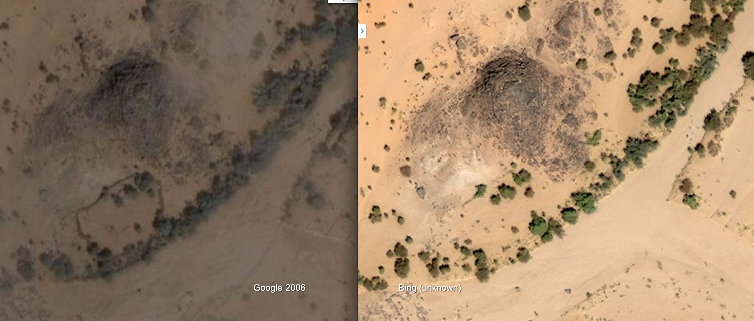
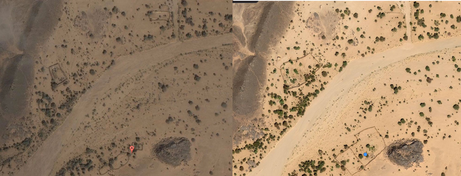
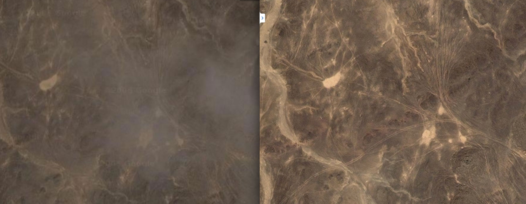
Bing vs Google imagery of Ametetai
Zoom out and around this Google maps link centred close to the site of the well as shown on the IGN map and you’ll see this ~17km2 sat image tile or quadrant (dated Jan 2006 at time of writing) is higher res than the surrounding ones. The next nearest in high res are Aguelhok and Tessalit (which we visited in 2006 laying plans for our big crossing of north Mali) so a random hi-res tile in the middle of nowhere always makes you wonder. But the Ametetai tile is also oddly spotted with unseasonal clouds for January, few of which have corresponding ground shadows which seems even more odd. Is this obstruction of ground detail significant?
For the first time comparing Google with the same area on Bing ‘aerial’ maps, it comes up as much brighter and cloud free – clearly from another occasion and time of day. On Bing there’s much more cultivation evident (see above right) as well as better developed and unusual concentrations of tracks criss-crossing the hills as below right. This suggests Bing imagery is more recent except that there are more trees which implies it’s older. In my experience trees get cut down all over the Sahara quicker than they can grow back, even by a oued.
Continuing the comparison, some walled enclosures on Google are not present on Bing (above left), while a few more on Bing have been enlarged as above right and on the left (location upstream). Perhaps the ready-made stone in old walls was taken down to expand compounds elsewhere? Finally, are the shadowless Google clouds covering up something ‘tactical’ that’s exposed on Bing Aerial? Not as far as I can tell.
You can play this ‘spot the difference’ game for a while to try and fit what is now well known to all: the ‘narco-traffiquants‘ as Chad reports derisively describe AQIM/MUHAO/Ansar Dine, had a major stronghold in the Ifoghas as has been speculated on for years. And the Ametetai valley was probably it. Here they dug caches and laid traps while successfully camouflaging their actual presence from overhead drones and presumably preparing for the assault which finally came in the form of Operation Serval. The seeming expansion of cultivation and some enclosures in a place so far from other know villages with little evidence of actual dwellings might be seen as odd.
A couple of weeks later it was reported that fighting was continuing in the ‘Hades valley… 60km from Tessalit’. This could be the next, even narrower valley to the south of Ametetai in the Tighaghar massif called ‘In Tegant’ on some maps. An unusually dense mass of tracks joins the two valleys across the stony hilltops, including the image above right.
Note: Aerial images in the region may have been updated since this article was written
What is the ‘Adrar des Ifoghas’? ‘Adrar’ usually means a region of low hills, escarpments or plateaux, but it can mean a single peak or jebel, like the Adrar Asref in the IGN map above. The Ifoghas (pronounced ‘Iforas’) is a region of low and dispersed, rubble hills spread across northeastern Mali and is also called the ‘Adagh’ by some. Separated by broad sandy plains and dissected by slender oueds, the actual ‘massifs’ barely rise a hundred metres above the surrounding 500m plain and can never be said to resemble ‘mountains’ far less a ‘near-impenetrable range’ as some reports describe. There are no distinctive peaks to speak of, nor a contiguous massif like the Hoggar in Algeria or the Tibesti in Chad, although you could say the Adrar Tighaghar is a small massif or eroded plateau within the Ifoghas.
As with most low-lying Sahara hills, the composition is mostly sandstone or granite (as left), broken down by eons of weathering. In places this makes travel with anything with wheels very difficult or impossible, be it the sandy oueds which at least make natural byways, or more so on the crumbled plateaux to either side, as the Le Monde image left shows. In my experience in the Sahara, it only takes a few inches variation in the ground’s surface to reduce car speeds to jogging pace, be it sand ripples or rubble and rock ledges. Bikes manage a little better, but even on foot the effort on the sort of terrain shown above is hugely amplified. Nevertheless, for in the hills either side of the Oued Ametetai the only way in was on foot with helicopter support. (As the reports above explained, the French and Chadians did so from three sides on the final assault.) This sort of terrain is so gnarly it’s also frequently but incorrectly ascribed as ‘volcanic’ in origin, but whatever you call it, trying to across it in 40°-heat with a 40-kilo backpack while trying to dodge bullets would be hard work indeed.
However, as this blog points out, comparisons with Afghanistan’s much more rugged and allegedly betunneled Tora Bora where OBL narrowly evaded capture in 2001 are inaccurate (as is calling all the north Malian jihadists ‘Al Qaeda’). Having said that the Ifoghas’ location close to the borders of Niger and Algeria does match the Tora Bora along the Pakistani border. This must have been a factor or a welcome coincidence when the Algerian-based GSPC (later AQIM) first established itself here in the late 90s. Hostages were frequently brought down into the Ifoghas from the north or east to a place which has always been a remote outlier in Mali, with Bamako some 1200km away. You get the feeling the indigenous Kel Ifoghas Tuareg were pretty much left to themselves or neglected, depending on your point of view, while from my observations a minority of entrepreneurial Berabish Arabs (Moors) controlled a low-value smuggling commerce from places like Al Khalil (In Khalil) hard against the Algerian frontier. (That all escalated once light, compact and high-value cocaine entered the picture a few years ago).
More than the sporadically rough terrain, the main thing that hampers occupation in the Ifoghas is the need for water. There are no river or lakes of course, but in this sub-tropical south side of the Sahara there are few perennial waterholes as can be relied on in southern Algeria (left), for example and which are easily spotted on sat imagery.
One benefit of the bare rocky massifs is they drive what late summer run off there is straight down into the many oueds where vegetation gets concentrated and trees can sink their roots, and where wells can more easily reach the water table. Because of this the Ifoghas hills are more suited to nomadic occupation than say, the sandy void (or ténéré in Tamashek) which fills the northwest corner of Mali. We crossed this ‘empty quarter‘ in 2006; we saw our last tree near Ouadane in Mauritania and the next as we neared Ikhalil, north of Tessalit, some 2000km later. Nor did we see another soul apart from our rescuers who met us midway. (As far as I know the remains of my Hilux – right – are still in Al Khalil).
One Chadian soldier in this Aljazeera video filmed after the Ametetai battle (see also Chad TV link top of the page) described the area as having ‘heavy tree cover’ which seems an exaggeration. Sure, there are small clusters of trees along the oueds, but more likely the sandy creek beds, huge granite boulders and low cliffs are what made hunting down the well entrenched jihadists so difficult.
East of the Adrar Tighaghar Google depicts a well-used track (see map below) which doesn’t appear on any old maps and which leads up towards Timiaouine over the Algerian border and continues south to Kidal, about 120km southeast of Aguelhok. When I last travelled down the full length of the Tanezrouft piste in the late 80s, Kidal was the site of a political prison and off limits, but in recent years it opened up to a few intrepid tourists, visiting the Essouk music festival, nearby. The Tuareg group, Tinariwen (left) are originally from Kidal. This track would have developed in the more recent smuggling and kidnapping era as the Kidal region became busier. Doubtless many other tracks developed in the area as AQIM and later groups established themselves in this region over the last decade. With the long overdue Operation Serval, you’d hope that era may be coming to an end. So far in 2016, it doesn’t look like it.
It was a full, two-day drive from Bit Outene at the end of our 12-day Immidir trek to the base camp east of Tam airport for our walk up to Assekrem (map below) and down again. On the way we overnighted at Erg Mehajibat (left) and stopped off for some wafers and fizz at Arak where we said goodbye to Mohamed our Immidir guide. As always, these are curt, brief affairs, but he knew we’d all had a great time with him and his crew who were now trekking back from Bit Outene with the caravan, about a week’s journey.
Just before Tam airport we were met by Ben Kada’s boss, another Mohamed, who had more juice and biscuits for us – a nice touch. He invited me into his pickup and within an hour we were dropped in a oued to meet the new Kel Ahaggar camel crew and set off scratching around for firewood which would be lean in the Hoggar. As expected, it was a freezing night at 1550m (left) and we set off next morning along a oued leading north towards a piton of rock alongside a massif, one of the many column-clad volcanic plugs which give this central core of the Hoggar – the Atakor – its distinctive look.
After an early lunch (left) we continued our climb onto the evocatively named Plateau of the Sky Wind, composed of basalt rubble the size of baby’s heads. As with many mountain treks, we gained our altitude in sudden steps rather than a gradual ascent. The Sky Wind in turn led to our camp for the night (left), a nest of tan, granite boulders overlooking the cone of Adrar Hedjrine. Compared to basalt, granite is a much friendlier rock to spend time on. Once our pitches were set and with little firewood, we hunkered down under blankets, solved problem of Middle Eastern politics once and for all, and waited for another great dinner.
We stayed on the granite next morning as Honi our guide led us up, over and down into a basin called The Palm (left), from which we scrambled back out to rest under a smooth-lipped cave adorned with pre-historic cattle images. I can’t say I recall seeing rock art painted on coarse granite before, but supposing it was at least 5000 years old, it had lasted well. I always understood that ochre and other pigments survived so well on sandstone because of a chemical bond with the rock surface – could it be the same on less fine and less porous granite? We continued our scramble and emerged on another ankle-testing basalt plateau at 2000m (left). Below us the caravan passed along an easier route and led us to a palmy spring of Tin Amelout in the Oued Amsa for lunch.
As we washed and waited to be fed, a group of camels including a mother and her calf wandered by. The young animal was duly snared, knocked down and trussed up with much commotion, and then branded with a bar. Initially I thought this was an opportunistic grab of an unbranded ‘cleanskin’, but it turned out the mother shared the brand of our caravan’s camels, so the crew were just marking what was theirs.
Back in the Immidir I’d mentioned to the group that our Ahaggar crew might be more tourist savvy or weary than the Ahnet bunch, because in the good years this route would have been frequently taken by tourists. Honi, his young son, brother and brother in law were old timers with the agency (unlike the Arak crew), but for some reason they remained a reserved and occasionally unfriendly bunch, as in sneering: ‘Are you looking for something?’ as I helped unpack a heavily-loaded camel at the end of a day. Even Tayub who was from around here, knew the crew and had done this route 40 times, was more reserved. The cause of all this perplexed us but was either low pay or just tourist fatigue and boredom. It certainly wasn’t us who, after a fortnight in the desert, were an undemanding and acclimatised group. As on previous occasions, it was clear that they got the gist when we talked about this [in English] and occasionally made an effort, but really their heart wasn’t in it, unlike the Ben Kada agency itself or the guys from Arak.
The odd staging, with early or very long lunches also took some getting used to. We concluded that we were following an easy, ‘starter’ circuit aimed at recently flown-in tourists, and not hardened desert vets like us. The glum crew, dearth of firewood, occasional rubbish and car tracks, plus the sometimes bleak surroundings took the edge off the walk, but as a well-bonded throng, we took it all without complaint because it sure was better to be walking out here in the Hoggar than most other things.
After lunch the guides hooked the mother and newly branded calf onto the caravan and tried to shoo away the other roaming camels who’d lost part of their troupe. Even that evening at our camp by a chilly guelta of Talmest, the herd stalked us from the ridge top, like Apache’s about to attack. At one point the young calf escaped its tether and made a dash for the ridge, but was chased and retrieved by Honi’s 18 year-old-son. As in the Immidir, the ways of camel trekking were being passed down to the next generation. With tourism crippled year by year, whether they’d get as much of a chance to put it into practise, like their aged fathers, was another matter.
Flowering Sodom AppleDesert truffle
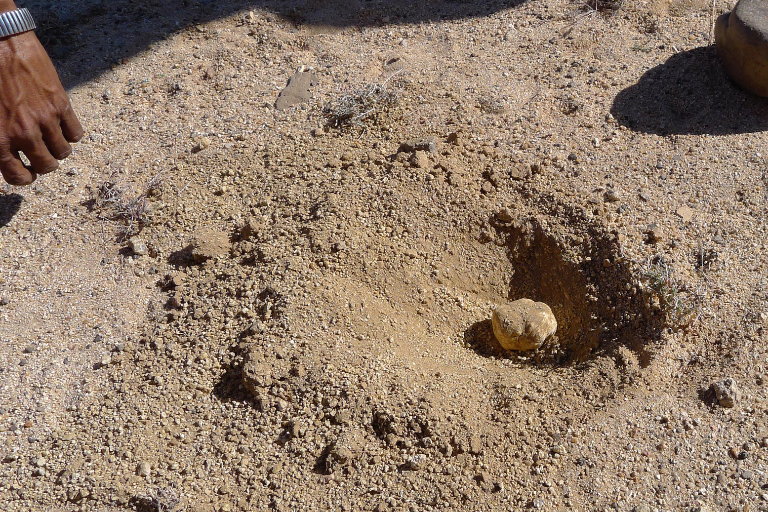
Cooler, less arid and twice the elevation of the Immidir, there were a lot more flowers (left) up here in the Hoggar, even though we were told it had not rained since the summer. I don’t know what any of them were but we were told it was the reason the hobbled camels set off up the rubble clad hillsides for a nibble every chance they got. At one point, after burning some plastic rubbish he came across, Honi stopped at a bulge of sand and carefully dug up a dense mushroom which I realise now was a truffle (left). Within a few minutes he had a few more and pointed to where rabbits had been digging others up. Just as he said that, a big rabbit or hare broke its cover and dashed off. I’ve never seen one before out here. Grilled on coals, the mushies made a delicious snack in the lunch oued an hour or two later.
That night’s camp at around 2200 metres was a grubby oued just short of the Assekrem track. This time we scoured the vicinity for scrub to burn, and using the oued bank wall, managed to keep ourselves warm under blankets (left) until Tayub brought over the dinner. Once the tea was served, we all made a dash for our sleeping bags.
Jackals howled overnight but by lunchtime next day we were at a cleared patch of ground by a small ruin, just below the col of Assekrem. Clearly it wasn’t going to be too balmy here tonight so we figured we’d earned a night indoors up at the auberge on the pass – all the better positioned to strike out for sunset and sunrise duties, too.
Up on top (left and below) a rowdy bunch of Turkish tourists were also enjoying the spectacle. Some of the world’s well known touristic wonders can lose their magic or be over-rated, but for me, like Ayers Rock or Monument Valley, Assekrem is no less amazing, even if you’ve been here half a dozen times. As expected, the ordinary meal we got back down in the lodge underlined what a great job Tayub our cook was doing in feeding us off the back of a camel for weeks at a time.
We all bundled into one room while the Turks sang and hollered till the early hours – and then before 6am the dedicated hauled themselves up again to stake their claims on the dawn. I took off up the rock opposite the hermitage (the lump on the right of the picture, left) where most go, sat myself in an enclosure against the wind and fired the camera into the primeval scene emerging from the night. I can’t say this vantage point is any better then the usual one, except that you’ll probably be alone.
After brekkie in the lodge, we traipsed back down to the caravan camp as arranged, but they were having a slow morning and the camels were still all over the mountainside (right), looking for those flowers. Once they were eventually brought in and loaded, we backtracked from Assekrem and set off for the three day descent, along a steep valley peppered with more flowers. Narrow clefts led over thick pools of ice, and out onto a plain we passed a nomad camp. As the day ended we set down in another oued with the Atakor’s spires behind us (left) for another freezing night mitigated by a bush scrub fire. A changeable wind rose after sunset and by 4am it was howling a gale. The empty tent I was using as a windbreak flapped remorselessly, making a racket; in future I’d be better off just huddling down under a quiet blanket like the nomads.
The secret of a good group is that they remain cheerful even after a grim night where few had slept well. Some had crawled in to share tents, and others had their tents snap over them, making an even worse din. Breakfast was delivered with stuff flying past and we then set off down the valley. Soon we joined the main, eastern arm of the car track to Assekrem which we followed briefly and then turned off at the twin ‘Mac D’s’ arches for the guelta at Afilal.
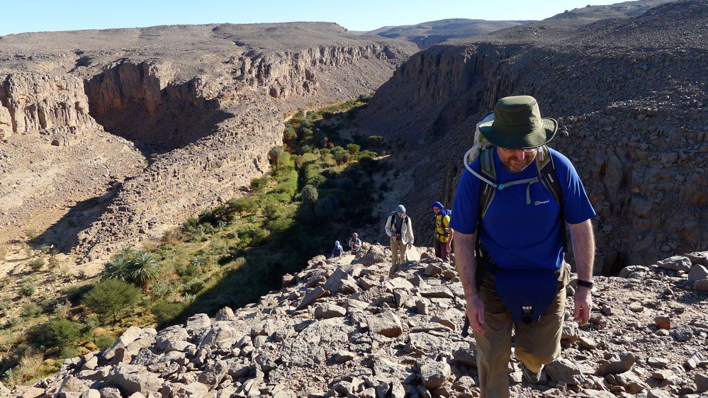
I’d never stopped here before. I think I tried to once but was shooed away by the army. Even then, I assumed it would be a grubby, rubbish-strewn dump, especially if army were camped nearby. In fact the Ahaggar national park guardian based there in an old portacabin was thrilled to see tourists and grabbed a photo with us for his next newsletter while behind us volunteers (or possibly miscreants) lethargically collected rubbish scattered around the main guelta. In fact there’s a lot more to Afilal than that waterhole and with Tayub and the lunch camel alongside, we followed the source downstream past trickling waterfalls, deep green pools and smooth, flood-washed granite until we found a wind free corner for another great salad lunch. I’ve never seen so much running water in the Sahara.
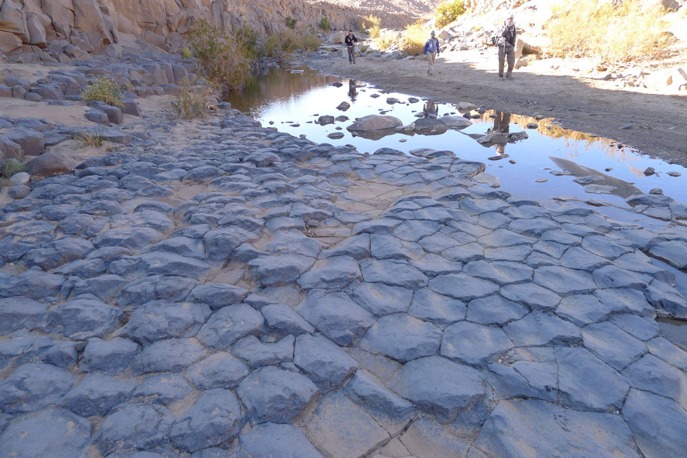
That afternoon was one of the best of the walk, not least because we put in a good 15 clicks after lunch. We followed the Afilal valley until it petered out and then crawled over low ridges into adjacent valleys and basins separated by more hills. Away from the grim basalt plateaux, we explored the granite ranges, passing a cobbled stone circle (left) just like the one we saw in Tadant oued, some 200km east of here at the tail end of SEQ in 2006. What they are exactly is still a mystery. A tomb is the most obvious answer, as these are the structures which most commonly survive, but most tombs have a focal point like a mound; this was just a very finely set flat ring of stones. It may just have been a pilot’s marker like this, but they are usually much bigger and out on the plain. Nearby, less well made examples had broken up over the years and in a nearby guelta, a flood-carved basalt pavement (below) added a natural wonder to the scene.
The caravan had taken a more direct route, but Honi was unsure where they had made camp. He crissed crossed the terrain, looking for tracks just we were beginning to creak a bit after hours of walking. Eventually we backtracked (see the map track) and staggered into another perfect camp in a oued set among beige granite boulders. Here we managed to scrape together enough acacia to encircle a fire ahead of our last day of trekking. That night it was probably minus 5.
Another great morning led us through the boulders to Akar Akar mountain to cross over the car track and get back inside the Hoggar ‘loop’. Steve had chosen to ride a camel that morning, little did he know he would be sat on the acacia plank till lunchtime, but when we caught him up he was fine. To the south lines of cones marched across the horizon in the blue haze and by mid-afternoon one more basalt rubble ascent and descent brought us above the last oued camp near the distinctive cone of Adaouda where Patrick found a fine Tuareg dagger while looking for fire wood.
I’d long wanted to try this walk and the Hoggar trek had passed through some amazing country side. But we couldn’t help compare it with the wild Immidir we’d just visited where the most conspicuous signs of man were usually 6000-year-old tombs. Tayub kept us as well fed as before, but the grumpy crew too took the edge off the experience and the sun rising or dropping over Assekrem is no less amazing for having driven up there so I’m not sure I’d do this trek again.
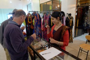
So, after 200 miles walking and nearly three weeks of bush camping, all that remained was a long overdue hose down at Loukmane’s house in Tam, followed by a haircut, some interneting, shopping (left) and a non-goat based feed at a resto in town. The night plane flew us back to Algiers via Djanet which gave us an extended chance to doze. A few hours later we were all on our way home while I conjured up plans for next time.
From the centre spiralling out anti-clockwise: RobUK, Rob, Diane, Hannah, Patrick, Mike, Steve (on top), Honi (below).