Tag Archives: Bordj Omar Driss

Algeria – For a Few Dollars More

Marseille – Tunis – Nefta – El Oued – Grand Erg Oriental – Deb Deb – Illizi – Djanet – Essendilene – Bordj el Haouas – Tazat – Amadror – Tourha – Tefedest east – Ideles – Tahifet – Tamanrasset – Assekrem – Tam – In Ecker – Amguid – Erg Tifernine – Gara Khanfoussa – Bordj Omar Driss – HbG – El Oued – Tunis – Genoa

Land Cruiser HJ61, Land Cruiser HDJ80 auto, Defender 300 Tdi

With just a couple of cars booked on the March tour, I planned to make the most of a small group and explore new areas that would be problematical with a bigger group. At Marseille Lucy and I met up with Ian and Elke from Wales in a well set-up Defender, and retirees Peter and David in an auto 80 TLC with nothing more than a second spare and a box for the jerries. Peter had bought the 80 just for the tour and preferred the low key ‘school run’ look.
The Marseille crossing was deserted and as flat as it gets. And better still, filling out the Tunisian immigration forms took just 20 minutes, whereas on the more popular Genoa run it can take six tedious hours. I guess it’s because Genoa is a funnel for the hoards of German-speaking Saharans, and of course that crossing costs 25% less.
But Marseille has other advantages apart from less crowds: it leaves earlier in the day so it gets in to Tunis early too, making a daylight run to the Algerian border possible. Rural traffic in Tunisia may not be so mental, but if it’s your first African driving experience you don’t want to be doing it in the dark. So after a hot, windy day we arrived at Nefta just on sunset and early next morning got through the borders in a couple of hours.
My plan was to avoid the long schlep south down past Hassi Messaoud and try one of the lately ‘fashionable’ pistes that cut through the northern Grand Erg Oriental down to the El Borma Road. These routes have the attraction of getting off the highway early, but involve traversing the northern Oriental Erg’s notorious small dunes. The problem with small dunes – as we were soon to find out – is that they have no clear form, being just a chaotic jumble of akle, rather like driving through a very heavy swell. Big dunes (as found in the southern Oriental) may have more scary descents but at least form into regular ridges (seifs) separated by gassis or corridors. You roll along a corridor and once in a while hop over a ridge of dunes to the adjacent gassi. If only…
Planning to get all the way to Hassi bel Guebbour through the Grand Erg (500km), we fuelled up at El Oued and turned off the highway near Oued Allenda village. By then a hot wind was blowing from the south reminding us the hot season was on its way. I had a dozen waypoints from a friend and soon we were in the dunes, riding through the swell.


After a few kilometres the tracks veered west but I made the mistake of heading directly for the next waypoint (this route was to be a reminder in reading the terrain first, then a GPS!). Twenty minutes of that saw me battling the Land Cruiser from one dune to the next. I knew this route was no cake-walk, but 200kms of this made 600kms of tarmac to HbG extremely alluring. We returned to the tracks (easier said than done) and I recce’d ahead with Ian in the Land Rover to discover the tracks did indeed turn our way after a few kilometres.


That night scorpions visited our camp. No one was more surprised or repelled than me, having never seen one in 20 years of desert travels. Yellow and only about an inch or two long, they put the dampers on our first desert camp as those of us in bare feet tiptoed gingerly towards their footwear. Lucy had lately read about Lhote killing 168 scorpions on the Tassili plateau in one sitting so Peter and David postponed sleeping out and put up a tent.
Next morning the hot south wind continued to blow, obscuring the sky and horizon and offering me another novelty; static electricity. On some days, every time I got out of my car I got zapped.
The tracks we’d recce’d the previous evening led into a tussocky flat area (as gassi as

it gets around here) which circumnavigated the dunes I’d tried to plough though yesterday. Presently they led to the well of Thleth el Biar where some Chaamba nomads were watering their herds. Compared to affable (or more tourist-trained) Tuaregs down south, these guys didn’t have much to say and indifferently took a bag of clothes we left by their car.
Nearby Ian spotted some sand roses growing in the sand. Being more humid than the deep south, the northern Erg is famous for these unusual crystalline gypsum formations which at best can resemble a pink rose. Firstly scorpions and now static and wild sand roses, what other novelties awaited?
None I cared for. From the well the sand was trackless so we muddled south into dunes, passing another well surrounded by nomads. For me the dilemma was: get stuck in to whatever led to the next waypoint, or follow the easier ground and risk getting led off route. Often we’d work our way into a mass of dunes only to see the preferred flat tussocky area half a kilometre to either side but still 20 minutes low ranging to get there. On the flat ground, such vantage points were not possible.
I’d driven in terrain similar to this, but never as the lead car, a big difference. Following someone takes a bit of concentration but is easy: whatever the lead car gets through you can usually follow, and where it gets stuck you have time to think and find a better way.


Both Ian and Peter thought this was all brilliant, real desert driving! but I just chewed my lip and wondered how bad it would get. I’ve never been keen on dune driving, it’s no surprise that it’s where all accidents happen and dunes are hard on the transmission and your nerves. In the Nefta hotel we’d met a Belgian guy who’d rolled his 80 in the Grand Erg near HbG. He was hanging out there while they replaced all the windows and bashed it back into shape…
Not only was the driving demanding but the terrain was pretty dull too, not helped by the dreary visibility and hot winds. Dunes tussocks, dunes tussocks. Occasionally we’d come across a gravel patch with clear tracks which confirmed we were on target, even if we felt lost most of the time.
Luckily both Ian and Peter (who’d never driven off-road before) seemed to manage it fine. I assured them this sort of driving was not the norm, but it being the start of the trip, they didn’t seem to mind being thrown in the deep end. My idea to come this way with six bikes a couple of months earlier would have been a disaster for sure.

We covered just 100km that day and another 100 the next, getting close to the El Borma road. And by the afternoon of the second day the dunes where getting higher, more spaced out and more regular, which made the terrain easier to negotiate. But not that easy. At one point I was working my way through a pile of dunes en route to the next putative waypoint. Trying to keep moving in Low 2nd, I rode from one crest through a bowl to the next, higher and higher until it was clear it wasn’t going to work out. There seemed no order or pattern, I was just a cork bobbing around in a pail of boiling water. I found myself doing something I’d only discussed hypothetically in the book: “wall of deathing” around the rim of a bowl in an attempt to maintain momentum and height while trying to work out what next. In the end I fell off the tightrope, almost willingly, with the car beached diagonally near a crest at a jaunty angle. And again. from this skewed vantage point one could spy the flat valley of t••••••s just half a click to the east.
We extracted ourselves and worked our way round, but a while later the same happened and I found myself mired in a bowl of custard powder with no room to move forward or back. Having never used them in three years, I’d left my sand plates at home but even Ian’s sand ladders couldn’t give the 61 the lift it needed. Towing merely pulled both cars into the sand, so we resorted to dragging the sunken Cruiser out by the arse with Ian’s winch. Handy thing in this situation, a winch!

With the weather almost brightening up and the dunes now rising into impressive formations, we counted the kilometres to the road and decided to leave the southern 300km stage to HbG for another time. Unused to his car, Peter had kept the auto in Low Range rather too much and would not have had enough fuel anyway. And we didn’t want to risk another 2 days in the dunes and get behind schedule.


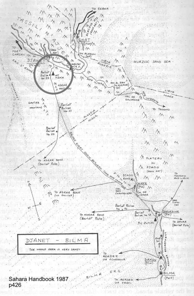
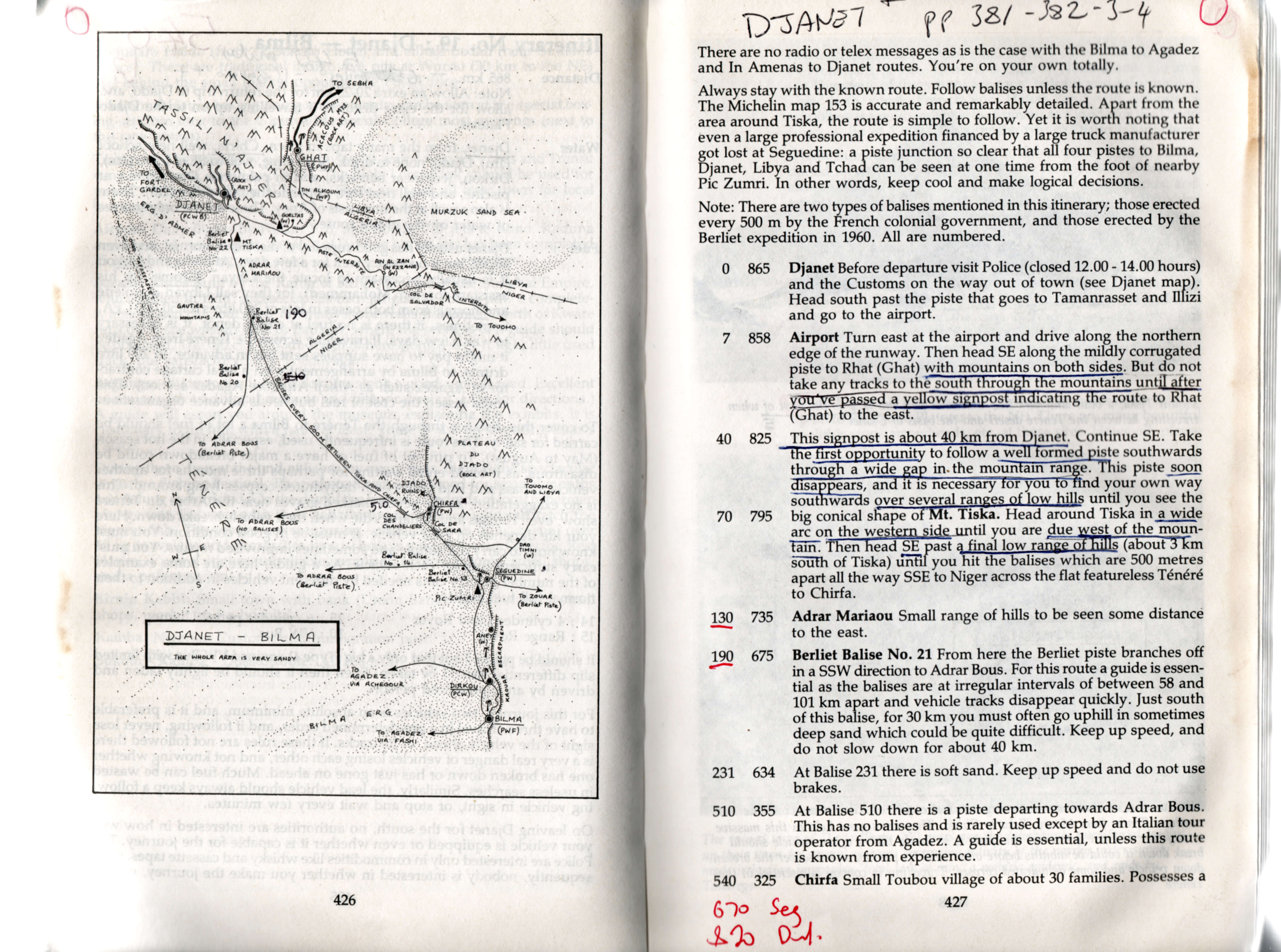
But instead of scurrying back to Hassi Messaoud, we turned east along the pipeline to El Borma and then down towards Deb Deb, another new route for me and one which I’d heard was notoriously buried in sand. South of Sif Fatimah the buried road section began. Bulldozers and JCBs were working to clear the side track and one amazing articulated 6×6 machine with ex-747 tyres gently pulled me through a bank. The tarmac is built on an embankment through huge dunes, but for kilometres at a time it disappears under the sand, with the side piste not always being much easier. Peter was eyeing his fuel gauge but we made it into the nice-looking border town of Deb Deb next morning, filled up with water, fuel and bread, and trundled on down the dull highway through the eastern oilfields to Illizi and a hotel.
Over the Fadnoun the weather was still overcast and dull, to be expected as the seasons change in springtime, but still disappointing. Lack of blue skies really does dampen one’s impression of the desert. Near Tin Taradjeli where the plateau ends we turned off to check out the Sleeping Antelope engravings in Oued Dider, but were content to stop by a two-tier guelta for lunch.
We also decided not to spend a night in a Tassili canyon and pressed on for Djanet and a rest day before a planned 4-day plateau walk. Just as well as what is usually a wonderful drive along the Tassili’s southern scarp soon became lost as an afternoon sandstorm swept in from the south, obliterating the tarmac itself.
In Djanet I set to changing my back springs. I’d been given a set of parabolics to try out. The fronts seemed to work OK but the back ones (fitted just before I left) were clearly not up to it, especially if I was to return home with enough Algerian diesel to last the summer. Expecting such problems, I’d brought along my trusty Old Man Emus and Hey Presto! the Tojo had some air in the wheel arches again. I flogged the back paras to the car spares shop near the market. Djanet is chock-a-block with erstwhile TLC 60s, though those mushy back springs will be as much use to most Djaneteers as fishing lessons.
It became likely that the guide I’d booked for the plateau walk was not going to turn up – oh well, that’s Africa, none of us really minded. And for me, four extra days meant less rushing around the desert. I’ve waiting 20 years to see the plateau, it will be there next time.

We popped down next afternoon to check out the Crying Cow and again another mid-afternoon storm blew in. I tried out the auto 80 and I must say I was not that enamoured. It felt like a heavy slug, very comfy and quiet of course, and featuring a lot of dashboard action. Pete was not that impressed either, finding the lack of pick-up at very low speeds (a feature of 80 engines, compared to earlier 12HTs) in dunes a problem. But either way Ian and I assured Peter just 20-30 seconds in either the Tdi or my 61 would soon highlight the 80s overall appeal.
Although the campsite guys were keen to offer us a plateau deal, we decided to move on and left Djanet under blue skies. On the recommendation of a couple of French guys, we took off up Essendilene Canyon (80-odd kms from Djanet, not 30 as in the book, p. 406), a lovely drive into the Tassili’s interior ending at a fern-lapped guelta.
Following another couple of tips I decided to concoct a new route to Ideles. First through a pass north of Mt Tazat which Richard Washington had found over Christmas, and then across the Amadror plain directly to the Tefedest and down A6 to Ideles.
I made a bit of a mess getting to the Tazat Pass, coming too much from the northeast across all sorts of rubble which slowed tyre-twitchy Peter down to glacial speeds. But by sundown we were 10kms from the mountain and a recce up a nearby hill showed a likely way in.
That night was clear but soon after we went to bed a gale blew in from the east and kept up the whole night. It’s one of the advantages of sleeping in a car as Ian and Elke did. Our tent flapped annoyingly all night while Peter and David rose after a night on the sand like a pair of crustaceans.


Stout old cairns marked the way into the pass next morning. Who knows why the French bothered establishing this route while the main piste passed south of Tazat. Whatever, it was a lovely, quiet drive and nice to be off the corrugated piste, even if it had now become oddly cold for mid-March. On the far side I returned to Borne junction after many years to find the old orange drum long gone and a chunky stone monument in its place. From here we took the route northwest towards Amguid, passing a nice Pre-Islamic tomb on a hillside. At a cone mountain south of Toukmatine we then cut out across the Amadror plain where Colonel Flatters and his crew met their end in 18 seventy whatever. It was a weird sensation driving across the flat plain with distant mountains bobbing on the horizon’s mirage. Slowly, as the afternoon wore on the Tourha range rose in the west, a bit like Adrar Bous as you come across the Tenere. There’s even a lone tree at KM321. Ian was leading for a change (he found trailblazing hard work too) and came across a gang of gazelles which inhabit this relatively secluded region.
As the day ended we reached the ‘Tourha Pass’ on a lovely evening and camped by a sun-warmed outcrop. Before dinner Lucy and I went for a wander into the hills and watched a little nervously as three cars drove past our camp without seeing it. Smugglers, locals or tourists? Who knows but we were glad they missed us. It being Mother’s Day, Peter could not resist my extortionate fee for the sat phone and called his mum in Surrey.
Even though we were only at 1000m, it froze that night to minus 2 or 3 and next day we carried on through the lovely pass and cut down towards the Tefedest proper, stopping frequently just to admire the grandeur of it all in the clear, crisp weather. On the far side of the Oued Igharghar we picked up A6 which I’d done with some bikes a few weeks earlier, met some smiley Targuias and their goats and followed this picturesque route to lunch at the green sign.
It’s interesting reversing a route you know well – you see so much more; new pistes and unusual rocks and even a new way into Ideles past a well I never knew about.
Ideles for me was the usual run around town trying to find the Tazrouk junction. I know where it is but never know how to get there from the west.

We were now on the outer ring road via Tahifet (A4) which I’d done for the first time in years with the bikes in January. Up to Tazrouk it’s a great track and this time Ian and I half-climbed the 150-metre old radio mast near Azrou to affirm that our arms and legs still worked after 2500km of driving.

But after Tahifet the wide track becomes Corrugation Central and we were glad to get to the highway south of Tam, pass the dozens of trans-Saharan trucks queuing for fuel and reached Agence Tarahist’s gite near Hadriane mountain. We’d just missed Moktar going out that morning with Jeremy Keenan (a controversial figure) and a group of no less than nine Brits, surely a record!
Tamanrasset merely reminds you how nice Djanet is, through it’s a good place to get stuff. Elke and I had had a running joke (well, it was to me) that the Hoggar was not worth visiting and we should spend more time in the wonderful Tassili. It’s a preference I’ve established on previous tours, but one that can only be made once one has seen both places. And Elke had been wanting to visit the Hoggar since she was a teenager.
So we trundled out of Tam next afternoon, chattering over the corrugations to the ever more dramatic ascent to Assekrem, seemingly smoother than when I last came this way in ’86. Up at the pass, we checked in full-board into the overpriced lodge and hiked up to the plateau. While the others primed their lens caps and took positions I went over to the north side of the plateau, having read of an alternative view in Sahara Man. In the end, it was nothing special but it was nice to get away from the others for an hour or so.
Evenings in the lodge follow a standard pattern. A faux Tuareg twatted about and took the piss out of a Chinese family. On a world tour, they’d tried to go to Egypt, settled for Tangiers but ended up in Algiers which sounded the same to their travel agent. What to do in Algiers but get sent down to Tam for the Assekrem Experience.
I’ve never seen dawn at Assekrem. The bikers (whose cutting limerick about my tour I’d uncovered in the lodge’s guest book the previous evening) had told me it was the one to watch. And they weren’t wrong. A little light cloud made for an amazing sight, even as the chill pre-dawn wind riffled through our blanket.
We returned to Tam the same way as Peter was worried about the tough western decent on his low and already dune-bashed 80. In Tam we had a bit of argy-bargy getting fuel. Peter’s row of empty jerries did not go down well at the back of the queue, even if other guys we’re rocking up with 50-gallon drums in the boot of their Renault 12s. A sack of bread and some veggies and it was off to In Ecker for another new piste.
On this stage Peter and I achieved a faintly phenomenal 36-40 mpg while Ian’s Tdi got it’s best at 26. The Tdi’s mediocre mpg puzzled me, although my experience on other tours is Tdis are usually the same as my 61. Was it Ian’s heavy tyres and rims and all those tanks, or the alloy roof wedge? Not likely. Overall, apart from in the Grand Erg, Peter’s cushy auto was usually tops: 5% better than my 61, with the Tdi around 25% below.
At In Ecker mountain we took off onto the Amguid piste, but I soon lost the track and wandered around most unprofessionally, while Lucy got to grips with reading waypoints off a map. Still, it all ended happily at a lovely campsite below a hill a few kilometres off the piste overlooking In Ecker mountain, still fenced off after a nuclear accident in the 1960s.
Up to Amguid the going was fast, passing the odd Dakar Rally wreck and the mysterious village of Abdemezeh where a German biker tour was having a cuppa. But by lunchtime a south wind was blowing again, hazing the sky.
At Ain Kerma well we barged in on the local Gendarmeries’ weekly wash and then headed for Amguid, Years ago I recall reading (in the Sahara Handbook?) that Amguid was populated by obnoxious children, not normally found in Algeria. I joked about this to the others who noted that these children would have grown up by now. How wrong we were. We stopped in the dilapidated once abandoned village to hand out the last of our clothes and were immediately besieged by clawing hands. This was not the exuberant ‘toubabery’ of West Africa but manic desperation. The adults pulled back the youngsters only to snatch into the cars themselves and it all got faintly scary as they surrounded Peter’s car where all the goodies were. We raced off, left our cadeaux on the ground and moved on as the crowd ripped into the bags.
Just north of Amguid we crossed over a pass onto the ‘Graben Piste’ which I’d wanted to do for many years. But that night another sandstorm blew up, this time from the west, and kept blowing all next day. It was dreary driving over rocky tracks with little to see, but that’s the desert: not every day’s a winner and some days are worse than others…
At Hassi Ntsel a band of dunes ran across the track. Unable to see an alternative route clearly, the dunes, no more than a kilometre wide, looked no worse than those we’d driven over in the Grand Erg. So rather hastily I got stuck in, got stuck, backed up, recce’d a way on foot using the others to stand as markers and bundled the cars through. On the final dunelette my car came down hard on the front corner: result, both front leaves (there are only two with parabolics) snapped though. With sand blowing all around, getting under the car was uncomfortable, but Ian and I managed a good bodge from a block of wood and a spare bump stop, a chain and a ratchet strap. I doubt the block lasted more than a few kilometres, but with the axle lashed to the chassis with chain and strap, we carried on at a much slower pace while I tried to visualize various meltdown scenarios and how I’d deal with them.

In the end, renewing the ratchet strap ever day or so, the car got all the way back to London on the bump stop with the broken leaves flapping. Whatever rubber they use to make Tojo bump stops, you’d better hope you have some on your parabolic car… The break was not a total surprise as the same happened to Yves’ parabolicked 109″ a couple of months earlier.

Thankfully next day the storm had blown itself out, just in time for us to round the rocky spur of Erg Tifernine, the most spectacular sections of this route where the stunningly red dunes flow over an old colonial track winding through the rocky hills.

From there right up the east flank of the Erg to Gara Khanfoussa was smooth sand, ideal for three-leafed Land Cruisers as well as a good place to spot Neolithic detritus.

Like I said, reversing known routes can be interesting, but it can also get confusing. Having come down through Khanfoussa a couple of times recently, coming back was a whole new game, especially with all traces blown away by yesterday’s storm. At one point I got to a huge dip that I didn’t recall and doubted I could get through. I tried to keep high and ride round one side, a possible way out. But with the car tipping ever further and Lucy getting ready to lower the lifeboat, I gave in just as we neared the crest, and swerved down into the pit. In fact getting out was not so hard, but watching Ian come through, a tiny Land Rover rolling down a 40-metre slope was scary.


Getting into Gara Khan’ hill, the halfway point in the dune crossing, had been easyish, getting out was not. I followed what faint tracks there were, tried to visualize the route in reverse, but soon got in a muddle and ended up following day-old tracks to another thought-provoking slip face. An overdue check on the GPS proved that we’d overshot the western exit by 10kms. Worn out by nursing the car and irritated by my confusion, we set course for a known waypoint at the western entry and rolled over the hills and dunes to a sheltered camp nearby.I was in no hurry to drive my limping car along the rubble track to Quatre Chemins and so next day, out of necessity and a bit of curiosity, we took the piste directly into Bordj Omar Driss along the base of the escarpment. Some nasty soft sand apart, it was a nicer route, passing by an amazing cliff of red, green and white interlaced strata that would have geologists drooling.


With every mile it seemed likely that the bump stop would not disintegrate and once we got back on the tarmac near BoD, I was sure the 61 would make it back the 1500kms to Tunis, and beyond.

On the boat I met up with some bikers including a Lido who’d come up from SA with a mate in a troublesome Td5. La Goulette had been packed out with 10 times the vehicles we’d seen coming out of Marseille. The Tunisians were making even more of a meal of boarding than usual and we didn’t leave until 11pm. As the boat eased into Genoa next day, Lido and his mate congratulated each other on making it across Africa to Europe. Me, I felt sorry for them. What were they going to make of Europe after nearly a year in the bush? They’d been given some skimpy directions for a campsite that might be open nearby. They reminded me of my own early Saharan rides. Bugger that I thought. Lucy and I said our goodbyes to Ian, Elke, Pete and David and attacked Genoa’s one-way system like a band of small dunes in search of the Novotel.

Tenere Troubles (2001)

Richard Washington
  • Tunisia, Algeria, Niger, Burkina Faso
  • December 2000 – January 2001
  • Landrover Series 2A 4 cyl. petrol

Tunis

We left Marseille on 10 December ferry to Tunis. The ferry was only about 1/3 full making the loading in Marseille uneventful compared with our trip a week closer to Christmas in 1999. The ship docked in Tunis at noon with clearance through Tunisian immigration and customs taking a mere 30 minutes (compared to 5 hours in 1999) allowing us to reach the salt pan of Chott El Jerid near Nefta (Algerian frontier) shortly after dark. We camped on the salt pan, leaving early for the border crossing the next morning.

Algeria

Clearance out of Tunisia took about 30 minutes but entry into Algeria just over 4 hours. In that time the officials processed only 3 cars, two of which were Algerian. The officials were nevertheless friendly. Two German bikers were crossing into Tunisia as we were leaving. They had ridden a loop from El Oued to Djanet then onto Tam and back along main route through In Salah (which included a convoy).

The Algerian border formalities correspond exactly with those described elsewhere on this website (immigration, customs, compulsory money change and car insurance). The only problem we had was with customs insisting on us filling in the form to reflect ‘Landrover’ as the type of car but ‘Toyota’ as the make. I guess this finally signifies the death of the British automotive legend, in this part of North Africa at least. [It was the same story with one of the LRs on my tour too, but caused no probs. CS]

From the Algerian border we headed on towards El Oued. There seemed to be few camping possibilities along this stretch given the awkward hummocky dunes lining the road and the proximity of villages. About 20 or 30km from El Oued, while entering one of the small villages, a group of youngsters aged less than 10, stoned the Landrover. No windows were broken but a bit more topography was added to the body work – never a serious issue in a 30-year-old vehicle with an aluminium body. We were welcomed into El Oued by the police and local businessmen alike. El Oued was calm and the streets clean and quite empty. We changed money at one of the banks.

That night we slept on the south side of the road 60km short of Hassi Messaoud. A strong north-easterly was drifting sand in a conveyor about 1m deep so we were looking for shelter behind south-facing hills. There is a small escarpment out of view of the road (N32° 10′ 37” E5° 52′ 23”) which served the purpose on a stretch that offered few alternatives. We arrived in Hassi shortly after 8am the next day. Here the military checkpoint issued our laissez passer in about 20 minutes. It was valid for a month. We were waved through the south side of Hassi en route to Hassi Bel Guebbour. The next check point was at Gassi Touil. Here the military spoke very little French, but seemed to want us to return 3km and wait at the side of the road. We went back, found nothing at the road side and so returned to the checkpoint. After a bit of discussion amongst themselves we were eventually waved through. We now know that a convoy operates on this stretch and may entail a delay of several hours until the convoy leaves.

If you have ever looked out of the window of a 747 on a night time trans Africa flight and seen two tiny pin pricks of light in the insanely massive blackness of the Sahara, the chances are that you are looking at somewhere like Hassi Bel Guebbour – with the two lights shared between the fuel station and the shop, this being the first fuel after Hassi M. It has a great sense of isolation and the interdune corridor that the tarmac follows south from Gassi is stunning.

Some 50km east of Bel Guebbour (28 36′ 10”N, 7 5′ 27”E) we passed large pools of water in an otherwise dry river bed. Although it was fairly early in the day we couldn’t pass the opportunity by and so set up a pleasant camp a few kms clear of the road out of the still strong north-easterly. A piste runs south to Bordj Omar Driss which starts parallel to the road [I have been told to avoid this piste – plenty of oilfield security].

The next day we called in at In Amenas (the bakery was selling awesome custard slices) and headed south through the huge dune field which seems to be the far western limb of the Ubari sand sea, eventually camping off the road in a sand field in the lee of a shady glade of trees (N26° 56′ 23″ E8° 41′ 54″). Firewood was plentiful. From our campsite we drove early the next day to Illizi for fuel and then on across the Fadnoun Plateau. The new road is a bonus but twists sharply without warning. It is rather like a pub video game where a blind rise could be followed by a sharp left, u-turn or a stranded truck jack-knifed across the road. The whole route from Illizi to Djanet is beautiful. We camped about 100km short of Djanet in a large dry river bed (N24° 54′ 56″, E8° 45′ 87î”). It was a stunning setting and well worth a few weeks stay. In Djanet we had a pleasant stay at Hotel Zeribas, camping in the far corner under the reed shelters. Djanet offered a great selection of fresh veggies, telephones which work given a bit of patience and pleasant temperatures. South of Djanet the daily temperatures were well over 30 degrees.

Whilst settling down for a quiet brew of tea in our campsite at Hotel Zeribas, Andy Pag drew up in a blast of diesel from the old Datsun he had brought down from Belgium. By this stage he was travelling alone and therefore keen to join us across the Northern Tenere to Chirfa and Dirkou. This was the planned next leg of the trip. We were glad for his company because the piste from Djanet to Dirkou is a lonely 850km stretch (we passed no traffic on this entire route).

Although our time in Algeria was much shorter than planned (for reasons explained later), we found the country calm and enjoyable to travel in. The only military checks we passed through were at Hassi M, Gassi Touil, and Hassi Bel Guebbour. Apart from this stretch, we were free to come and go as we pleased. Whenever we encountered police we found them very helpful and accommodating. From a tourist perspective, everything is in place for Algeria’s recovery – all that is missing are tourists. We saw none between the Tunisian border and Agadez (about 5000km) except for Andy in Djanet.

After some time to rest and check out Djanet, we took off for Niger, leaving by the piste to Libya (a left turn off the new airport road past the old aerodrome). We turned off this mildly corrugated piste about 35km from Djanet, taking tracks through a gap in the mountains towards Mount Tiska. Once the tracks join, the piste is surprisingly well formed. After about an hour (roughly 40km) the piste turned east of Mount Tiska. The area is very beautiful with just about every spot a perfect campsite. We spent the night here with Andy cooking up a great veg stew. During the night we saw three vehicles approaching the Mount Tiska foothills some 10km to the south. They stopped when in view of our fire although we couldn’t be sure they saw us. They set off again well after midnight once the moon was up, passing within a few kilometres of us with their lights off. This all seemed to point to smugglers taking Marlboro into Algeria possibly via a piste through the Djado plateau.

We continued on the well-formed piste the next day. Within an hour it was obvious that the piste would pass well east of the Adrar Mariaou mountains. The piste is not marked on the Michelin or the TPC maps. Since we wanted to hook up with the balise line across the northern Tenere (which lies west of Adrar Mariaou) we left what seems to be a smugglers piste, taking a drainage line out onto the flat northern Tenere. The surface was better than any tarmac we had driven since France. While the route sounds complicated, the desert is very open with the Mount Tiska and Adrar Mariaou mountains clearly visible all the time. All the driving was easy. Within an hour we had gained the Tenere and found the first balise. There we several old (and a little indistinct) tracks along the balise line. Our GPS position showed us to be on the eastern most of the two pistes entering the Tenere which are marked on the TPC J 3B map. As the balise line piste appeared to be the western most piste on this map, we seemed to be on the wrong line, and so headed south-west to see if we intersected any other piste (although we were sure that there was only one balise line across the Tenere and that the TPC marked piste was wrong – but the check was easy to make and the surface pretty hard). It turned out that the piste marked on the TPC is wrong.

After about half an hour four Toyota Land Cruiser pick-ups could be seen driving straight at us from the northern base of the Adrar Mariaou mountains. They were travelling at speeds up to 160km/hr. The group turned out to be the Algerian police. After making their AK-47s clear to us and checking our papers (carte de grise, visas, insurance etc) they waved us on cheerfully. We should point out that it is not possible to leave Algeria officially along the northern Tenere route south of Djanet. While the police don’t mind, the Algerian customs do not permit official exit.

The northern Tenere is simply awesome. It is difficult to put words to the vastness of the place. It is impossible at times to tell whether you can see 50m, 500m or 50km off the piste. There are three wrecks on the balise line, 2two from the 1988 Paris-Dakar race. The shot blasted dark silver chassis gleaming in the bleached light. For the most part the Northern Tenere is very easy driving. The first few hundred kilometres out of Djanet were softer, the Landrover not being powerful enough to plane over the surface. Immediately south of Berliet balise 21 the sand is deep and powdery. It was the only time between Djanet and Agadez that we needed low range. The soft sand persists for 40km south of Berliet Balise 21. In a newish Toyota the northern Tenere could probably be crossed in a day. We took two days of driving, but three days altogether.

Sahara Handbook route description from 1987

Niger

The exit from the Northern Tenere to Chirfa is clearly marked – nearly all the balises are in place across the Northern Tenere. On arrival in Chirfa we drove directly to the military checkpoint. They stamped our passports while looking over the vehicles, asking if we had any sat phones, short wave transmitters as so on. We helped the commander with his GPS as he had no manual for it. We left our passports with the military overnight, thinking that this was routine practice in Niger. We drove through the village and checked out the impressive Djado ruins. The next day we returned to the military post for our passports. By then the mood had changed and we were ordered to drive directly to Dirkou, not to leave the piste and to arrive there no later than 4pm. As it was already getting on to 10am it was a tall ask in our old vehicles. We assumed Dirkou was the first official border post (as marked on the Michelin map) on this route and hence the requirement that we shouldn’t linger on the piste. We found the piste south of Seguedine very sandy. Again it would be very difficult to get lost on this route – in fact we hardly bothered with the GPS. We arrived in Dirkou a little after 4pm, handed over our passports (which were again kept overnight), met with Jerome and drove off to town for the night. The military checkpoint was pretty chaotic as several 10-wheel-drive Merc trucks loaded to the hilt were about to leave for Libya.

We returned to the military post early the next day, waited around before asking for and being given back our passports (they now had stamps from both Dirkou and Chirfa). From there we headed up the hill to refuel (we had used about 220 L of petrol since Djanet; that’s 3.7kpl or 10.4mpg) at Jerome’s fuel dump. Make sure you take your own pipe / 12V pump as Jerome’s assistants seem to have sucked too much fuel through their brains over the years. They are several sandwiches short of a picnic!

Whilst we were refueling the military drove up in a Landcruiser and took back our passports and vehicle papers. Once we had finished refueling the military impounded our vehicles. We now had no passports, no vehicles and no vehicle papers. Things weren’t looking good. No explanation was given but we were told to wait until 3:30pm. We waited in a barbed wire area between the passport shack and the military base. This is a stinking hot, dusty, shadeless area surrounded by feche feche that we grew to hate over the next few days. At 5pm were we told that there was a problem and that we would have to wait until 9am the next morning. We later found out that the Minister of Defence in Niamey had already phoned the French Ambassador in Niamey to say that European nationals were being held in the north. The French Embassy in Niger deals with all European nationals in Niger.

The next morning we were told to wait until 3:30 pm as the commander of the military base in Dirkou was waiting for instructions from Niamey. Most of our dealings had been with the Chef de Transit at the passport shack on the outskirts of the military base. He had been telling us all sorts of lies about why we were being held and when we would be released. He was a very difficult person to deal with – at one point gesturing to me that he would tear up my passports if we didn’t leave him alone. Our main effort at this stage was to speak to the Military commander of Dirkou. Of course we could get nowhere near his office. Our vehicle papers, passports and visas were all in order and we wanted to know what we were being held for.

The commander finally agreed to see us late that afternoon. It was rather like meeting Kurtz. We were shown into this darkened, blue room with padded doors. The commander greeted us and asked what our problem was as he had heard we were anxious! We explained that our vehicle papers, passports and visas were in good order and that we were uncertain what the problem was. He explained that the situation in the north is difficult, that tourists coming into Niger from the north were a problem and that the only way to enter this region was through Agadez where all the necessary paper work was available and where guides could be hired. He assured us that he was working on a solution for us. We asked if it was possible to simply deport us from Niger and we would leave immediately back to Djanet the way we had come (this had been our plan all along).

Fortunately we had managed to get permission to be taken to Bilma (45km to the south) to phone our embassies. With our vehicles still impounded we had to find a way of getting there. The distinction between who was military and who was a tour operator was extremely blurred. We were charged 30 quid one way for the trip although we returned with a tour operator anxious for our business. They were an unpleasant mafia-like gang and things turned sour shortly after they dropped us off. Interestingly we were taken to the military commanders office in the military base in the same tour operator’s Landcruiser. In Bilma we managed to call the German consulate in Niamey (there is only an unofficial representative for British nationals who is a businessmen in Niamey – he didn’t want to know our case!). I managed to get a line out to Megan who was in Cape Town at the time. Megan phoned the German and British Embassies in South Africa as well as the German Consulate in Niamey, eventually being put on to the French Embassy in Niamey. This helped our case enormously, although we had no way of knowing she had achieved all this until our problems were nearly over.

Early in the afternoon of our fourth day in Dirkou we were told that we were being taken to Agadez. Remembering that the Commander of the military camp in Dirkou had told us that Agadez had all the services necessary to help us, we were relieved that the problems from their side seemed to be coming to an end. This soon changed when a Land Cruiser with a machine gun and live ammo chain mounted on the back rolled up. They were our escorts, so at least we didn’t have to take a guide! Our passports were still being held, so it was clear we were simply being transferred to Agadez. We protested that our 30-year-old series 2A was not up to the Dirkou to Agadez crossing of the Tenere, but we were told that there was no option: take the vehicle or leave it behind. It was do or die time for the 1950s transmission.

We left Dirkou at about 4pm. Although there was still problems to come, it was good to leave that stinking hot, dust riddled, barbed wire camp. The military Land Cruiser drove in front but waved us past in frustration at our pace. We drove on to the wells at Achegour which we reached by about 7:30 pm. It was amazing to be crossing the central Tenere although it was a pity it was not in circumstances of our own choosing. We drove through the night, following a star but basically heading west south-west. Again we didn’t bother with a GPS. With no sign of the military we decided to savour our freedom and drove on into the morning light taking a dune corridor about 30km north of Arbre de Tenere (make sure you are in the correct corridor if you want to see this place otherwise you need to back track about 30km). The going in the central Tenere is much softer than the northern Tenere. Our consumption dropped to about 3km per litre [8mpg]. We hardly ever got out of second gear although we didn’t ever get stuck. Where the sand is very soft all the truck tracks merge. Apart from a very high median strip the going is OK on the tracks.

We emerged from the sandy desert at about noon the next day to find the military waiting for us. The piste is up to 50km wide in the Tenere so they must have passed us in the night. We drove on to Agadez arriving in the early evening. The commander of the military camp in Agadez then met with us. He simply said that after a day’s rest we would be taken on to Niamey 900km away. This was probably the low point of the trip! After a few days we had another military escort down to Niamey. We left on Christmas day at 9am and arrived in Niamey at about 8pm. We had a young soldier in our Land Rover but separated from the others over the distance. We were held at the outskirts of Niamey as our passport were in the other vehicle. Then we decided enough was enough and I negotiated for a passport substitute, giving them some paper with work letter heads. From there we basically made a run for the French Embassy – the soldier protesting from the back of the Land Rover while we made out we didn’t know what he wanted us to do. We arrived at the French Embassy at 11:30 pm Christmas night and were greeted by the French Ambassador, the head of the French Military attache in Niger and the Head of the Internationale Police in Niger. They were all amazingly helpful. Details began to emerge that we were suspected spies/gun runners. The piste from Djanet to Chirfa is never crossed from north to south these days and so our arrival out of the northern Tenere had aroused much suspicion. There was also a suggestion that we had been picked up by a military patrol in the Northern Tenere. This might have been the commander at Chirfa trying to win himself a promotion, but it was certainly not how it happened as we had driven directly to the military checkpoint at Chirfa and found them all lazing about in the sun.

A meeting was set up with the Niger Chief of Police for the next day. The arrangements were made from the French Embassy shortly after midnight. We were very surprised when the meeting went ahead as it was taking place at lunchtime on the Islamic equivalent of Christmas day. It was at that meeting that our passports were returned. We had been held for nine days and had been required to drive about 2000km for the ceremony. The Chief of Police of Niger pointed out to us that he didn’t know why we were being held by the Military.

From Niamey we took the shortest route out of Niger – to Ouagadougou in Burkina Faso.

So if you want a trip across the Tenere from Dirkou to Agadez without the official guide, then just cross the northern Tenere from Djanet to Chrifa and the military is bound to oblige. The downside is that the trip goes at their pace! Our original trip had been planned to take in Libya, Niger and Algeria, so crossing the northern Tenere from south to north. Others have done parts of this route. Although the Niger military clearly don’t like tourists in the northeast, they seem to tolerate the route this way round. Our plans had to change when the Libyans refused our visas.

Return to Algeria (2000)

Route
Genoa – Tunis – Nefta – El Oued – Hassi Messaoud – Hassi bel Guebbour (HbG) – Quatre Chemins – Gara Khanfoussa – Ain el Hadjadj – Illizi – Iherir – Djanet – Tadrart (Oued In Djerane, T-in Merzouga) – Bordj el Haouas – Serenout – Ideles – Hirafok – Assekrem – Ideles – Tefedest east (Garet el Djenoun) – Erg Amguid west – HbG – El Oued – Tunis.
About 2500km off-road

upcruiser

Vehicles
Land Cruiser HJ61, Land Cruiser HDJ80, Discovery Tdi and three 110 Defenders.

dd2-front-med
The film of this tour, Algeria 2000
(as seen on Sky TV), is featured
on the Desert Driving dvd.

Ferry and Tunisia
It’s still the same story on the Carthage as described in the book, hours of queuing for forms. Not all of us got our Permit de Conduire before the ship docked, but they were quickly obtained from the Customs booths once in the port.

Before that, at the police booths in the first shed it helps not to imply you’re transiting Tunisia fast for Libya or Algeria. To keep them happy make out you’re spending some time (and money) in Tunisia too. One of our group got tricked on the exchange; led to a certain bureau de change by one of the orange boiler-suited guys. Be alert, they’ll get you if they can. And another was told to pay 10 dinars for his Permit de C. (it’s officially 1d or free on the boat).

Fuel prices in Tunisia: Diesel 41d, petrol about 70d.

We covered the 470km from Tunis to Nefta in about 8 hours and stayed at the Hotel Marhala in the zone touristique west of town, opposite the Caravanserai. Half board was around 40d for two people. It’s a clean new hotel with unusually good food (but what isn’t after the Amilcar in Carthage?).

The Border
We set off at 8.30am hoping to get a good start into Algeria but the border still took most of the day. The Tunisian frontier at Haouza was pretty straightforward. At Taleb Larbi on the Algerian side things move slowly. You do police forms for you and your car (white and green forms), move on to the Customs declaration (currency and valuables like video cameras or whatever you profer/they find). I was aware of the binoculars (jumelles) ban but was careless in hiding them and so they were confiscated with a receipt and returned on the way out. The others hid their binoculars better.

Each car was searched with a few suggestive jokes about whisky, but bury it deep and they won’t find it because you don’t get taken apart as can happen to locals. With your carte gris (vehicle logbook) you then fill out a Titre de Passage en Douane (TPD) form which eventually gets printed out.

Next is money changing. This seems to be a problem at Taleb Larbi. As Yves found, they claim not to have enough in the office and there’s no bank at Taleb. In our case I got 400FF’s worth but the others got only enough to buy insurance (about 200FF) and the last lot had none. It then transpired that the guy in the insurance office (‘SAA’) took FF anyway. This is probably best paid out of your declared FFs, not your stash.

While I was waiting, taxis drivers just past the gates offered to buy clothes and exchange black market money, offering around 10-20% more. If you’ve arrived low on fuel and you have insufficient official dinars you may need to buy some black to move on. The fuel station is just down the road. We left Taleb round 3pm.

At some stage of course you must buy official dinars (it looks good on your declaration – keep receipts). We did this at the bank in Debila, the first main town after the border. It had just closed but the guy saw the ten of us and generously opened up again to do a quick change for us all.

Stone throwing kids
I’d read about the stone throwing villages west of the border on sahara.info.ch and sadly the reports were true. For once I was spared but the Discovery at the back got hit hard two or three times. Most of the kids wave but the ones who throw mean business as the heavy dents in the Discovery’s door proved. Had it gone through a window and struck the driver it would have been nasty. The last car is usually the target because there are no following cars to see who throws it, I suppose.

Unless you’re lucky, trying to catch the culprits or going to the police is a waste of time, but I guess that some irate tourist with a smashed window will do this some day soon and hopefully something will be done. On the ferry back I spotted a tourist car with a smashed window and heard of serious stone throwing in Kufra (Libya) and even at a local guide’s car in Dakhla (Egypt).

Laisser Passer and Gassi Touil convoy
We spent the first night in Algeria in the sands just south of Touggourt (although there is the Hotel Oasis in town somewhere).

At Square Bresson (just a junction) there are masses of sand roses laid out for display. Soon after, at a checkpoint just before Hassi Messaoud we had to get our permit for the south – about an hour of writing everyone’s details down in Arabic. But the laisser passer was only requested a couple of times in the Gassi Touil over the next day or two. No one bothered with it or even passport checks south of the oil zone.

We got caught up in a military escort at the Gassi Touil checkpoint, halfway between Hassi Messaoud and Hassi bel Guebbour (HbG). It meant waiting until 3pm (or 9am) for a 100 km drive to another checkpoint or base and continuing the next morning at 10am to HbG. We were told only ‘Toyotas and fuel tankers’ must join the convoy as these have been preyed on by bandits (from ‘Mali’ or course). But while waiting plenty of Toyotas and tankers went through so who knows… It delayed us by about half a day so schedule this into your plans or go via Deb Deb (Libyan border route).

Unlike many other towns in Algeria, HbG is still the one-camel truckstop it was ten years ago. Just a couple of cafes and a checkpoint. There was no problem with us heading down to Bordj Omar Driss (stopping for a wash at the warm spring 2km from Hassi).

On the piste at last
We left the tarmac at Quatre Chemins (checkpoint) and headed west along the very rough Amguid track, leaving it early down a sandy ramp towards the Gara Khanfoussa dune crossing and the 410-km-run (fuel to fuel) to Illizi. Once you find the entry point for GK and the old piste rising up over the dunes, with 1.5 bar the crossing is very easy (in our case perhaps helped by the recent heavy rains). There are many recent tracks winding their way over the easiest dunes and by following them you encounter no dangerous crests to speak of. After the first section you drive into the Gara Khan clearing and then keep on the west side to head directly south (a mistake we made when I did it ten years ago). Beware of sharp ‘crests’ as you drive back onto the old orange built-up piste on the way out of the dunes.

Once in the valley we passed Tabelbalet well (good water at 6m), tried to drive along the dunes on the east side (as advised because of flood damage on the track). But the dune banks were tiresome and we found the track OK. Next day we passed Ain el Hadjadj (ruins, good water) and followed the track right to the point where you cross the strip of dunes at around N26 38′. It helps to walk these first to work out the way through. Once you know which way to go it can be done in 10 minutes. No one got stuck except me!

From here east to Illizi is one of the most beautiful pistes in these parts, with the rosey dunes of the Erg Issaouane glowing to the north, a clear track and plenty of nomads camelling around. Just when you think it’s all over there is a steep sand slope to ascend about an hour from Illizi (waiting for GPS info). You’ll need to degonflate to get up this one – watch out for the rocks on top.

If you’re heading south via HbG then this piste certainly beats the tarmac to Illizi.

Illizi to Djanet
In Illizi we were lucky enough to get fuel, water, bread and even a restaurant lunch (250d each) without getting hauled in to the police and army as Yves reports on point 11. If they don’t ask don’t offer. From here it was tarmac all the way to Djanet, covering in two hours what took a gruelling day a decade ago. We visited the village of Iherir (basic camping at the north end of the settlement – introduce yourself to the teacher, Ibrahim Kadri). The road to this canyon oasis is much improved (30 mins) and may well be tarmaced by next year.

We did the Tuareg tea thing with Ibrahim that evening and next morning went for a walk with a guide up the valley to see the guelta, gardens, rock art and the old Turkish fort (700D for our group of ten). We also left some old clothes with Ibrahim for the villagers.

Down the road, Dider looks as lovely a lunch/camp spot as ever and there is now fuel at what has become the small refugee town of Bordj el Haouas (checkpoint). You could do Illizi – Djanet in a day.

Djanet
The new tarmac makes a lovely drive into Djanet – now you can look around at the countryside instead of the piste. There was no checkpoint on entering Djanet (though there were frequent night time roadblocks) or need to get permits for fuel, as before. We stayed at the only place in town: Hotel Zeribas (250d to camp per person, cars free, basic rooms around 500d) right in the town centre next to the post office. I was told the place was dump a year ago but it looked fine to me, with hot water, plenty of shade and good security. They’ll try and rope you in for a cous-cous meal in their restaurant, nothing special and overpriced at 500d pp. There are restaurants just out the door. The Hotel Tenere, miles south out of town, appeared to be closed or waiting for the Xmas charters. There’s a shadeless campsite near it, but it looked deserted too.

Guided excursion to the Tadrart
I organised a guide with Agence Essendilene for a tour of the Tadrart (SE of Djanet) and Alidemma arch. We were advised that my proposed route would take much longer than planned (although a friend did the full tour a year ago in 4 days). It was a guide’s ploy to get more days out of us (a new one me!). In the end we settled on 4 days, Tadrart only at 1200FF a day. We also paid 25d per person per day in the national park at the park office/museum in town. Once we got to the Tadrart it was clear the guides were stringing out the route to fill 4 days, crawling along at times at 10kph. We would have rather driven at a normal speeds and camped early to enjoy time out of the cars, which we later did.

I was looking forward to the Tadrart but to be honest I was disappointed. The sandy drive out towards Mt Tiska and following oueds south of the corrugated Ghat piste was great (and driven at normal speeds). But Oued In Djerane was very dusty and for the price I paid, the region did not quite have the edge over the very similar (and contiguous) Akakus in Libya. Of course, unlike the Akakus, the Tadrart has zero tourists. The ochre dunes at T-in Merzouga were the highlight. Our guides Ahmed and Slimane were a good bunch of guys and, with an email contact in Germany, I may hire them again directly, at a more normal price.

Unfortunately one of our group was injured an accident on Day 3 and we had to return directly to Djanet. Amazingly the Defender nearly made it back in 2WD, at which point the severely traumatised transmission finally gave up the ghost. The doctors at Djanet hospital were extremely helpful and confidence inspiring. The injured driver eventually flew back to the UK via Algiers, with the aid of his travel insurance and looks like making a full recovery. The car was a write-off. There are no modern Land Rovers in Algeria, only ancient Series IIIs. Recovery to the coast was not worthwhile and so it had its contents and components ‘optimised’ and was left with the Customs. Vehicles cannot be sold in Algeria. The Douane huffed and puffed a bit about parts missing from their new ‘present’ (what a nerve!), but once they realise it’s more wrecked than it looks they won’t be quite so thrilled.

leapo


Telephoning from Djanet
Trying to organise the repatriation exposed the near impossibility of telephoning out of Djanet, even just to the next town. The problem seems to be many new private telephones but just one inadequate satellite/radio dish. I was on the verge of driving 400km to Illizi (linked by land lines and therefore much more reliable), but had one more go at sundown – Ramadan eating time when all goes quite. However the insurance never managed to call back. So despite what I say in the book on p.276, a sat phone would have been useful here. (incidentally the hypothetically described Medevac procedure on the opposite page – outlined to me by a Loss Assessor – proved to be pretty accurate. Getting to a town/phone/hospital is the key. However, the insurance insist on proof that the claimant cannot continue the tour as well as a doctor’s report to prove they are safe to fly. This is what cost us days and why we gave up in Djanet – they could not get through).

Not surprisingly, GSM mobiles don’t work in Algeria (they do in Tunisia), but I was told that next year they will, even down in the south.

Route A2 to the Hoggar
With the injured driver slowly on the mend, two cars from the group offered to help assist his recovery to the UK while I continued with the VX and Discovery to the Hoggar. We managed to get diesel at Bordj el Haouas (Ramadan shuts everything down at 3pm) and then headed south along the chain of mountains that end in the landmark of Tazat (an interesting area to explore for another time I think). Mistakenly thinking we needed to move fast to catch up for lost time, we drove from Tazat almost to Assekrem in a long 400km-day. As described in the book the junction at ‘Borne’ is still confusing and we dithered around a bit before heading resolutely SSW over confusing tracks with another lost G-Wagen crossing out bows. Soon we found the crucial cairns and balises that lead into the valleys all the way to Serenout fort (quick passport check) and on past Telertheba. Despite what it says on p.397, the southern route from Serenout (as marked on the IGN) seems to be the main way and is a lovely drive with the 2455m Telertheba looming ever larger up ahead. The sandy sections mentioned on A2 in the book didn’t cause any problems – one wonders if a flat sandy track improves with little passing traffic.

There is diesel only at Ideles from where a corrugated track leads to Hirhafok. At Hirhafok we turned south for Assekrem.

I knew this piste would be washed-out, but the closer we got to Assekrem the worse it got, to the point where one could barely believe anything less tha a Unimog could drive it. The last 50kms took 4 hours in Low Range with extremely slow and rocky going up to and beyond the Tin Teratimt Pass. From here on it was so damaged one could hardly work out the original track among the many deviations.

We had Assekrem to ourselves but there is a whole menu of prices there: parking, parking more than an hour, breathing, etc. The ‘chatty’ guy in charge tried to charge us for camping, too… To be fair it can’t be cheap to run the place and the lovely lodge is well worth an overnight (even at nearly 1000ds demi-pension) so you can see dawn over the plugs.

Tefedest East
We returned down the track from hell (not so bad this time but I doubt any local would use it), fuelled up at Ideles, getting caught up with the bored police opposite the pumps for a tiresome “what’s your job, address, mother and father’s name” check. Backtracking, the turn off north for Mertoutek is clear if you’re looking for it and the track unrolls clearly, passing through some lovely spots to a turn-off at a big green sign a few kilometres before Mertoutek (as marked on the TPC). From here twin ruts lead north to Dehine and continue all the way along the east flank of the Tefedest range past the distinctive peak of Garet el Djenoun at its northern end.

The Discovery’s rear radius arm broke, probably as a result of the exertions of the previous day, and with me taking on the car’s fuel and water payload, my 61’s rear main spring also snapped a day later. The flat helper springs had also snapped off I discovered, but the second spring sort of winds round the mount so I could carry on without much problem. The other rear main spring has since broken. I never rated these two-year-old Ironman rear springs for heavy load carrying (front are fine) and will be getting some heavy-duty OMEs.

We had a day off by Garet and then continued north along the west of the Amguid erg, through the pass and northwest back to HbG, a clear if corrugated track marked with oil drums much of the way.

This is a lovely way back north, easy to follow with no GPS needed – 710kms from Ideles to HbG. The last 150km are a flat and dull and after the final rise, the eastbound track back to 4 Chemins is very rough but can be avoided by going via Bordj Omar Driss, I’m told.

Back north
We just about managed to wangle our way out of a return convoy north, and continued slowly with the four-wheel steering Discovery all the way from Gassi Touil to Nefta in one very long day. Getting out of Algeria took two hours with no searches or money checks (the same as years ago), just very slow-witted officials at Taleb. At Haouza they asked for Green Card insurance (a first) so those without had to buy a week’s worth for 10Td. After 1200km of hairy handling with just a winch cable and a chain holding the axle in place, the Discovery got its radius arm welded in Nefta and we met up with the rest of the group at La Goulette for the ferry back to Genoa.

Weather
Following the severe October rains west of Illizi, we were blessed with no daytime wind and amazing clarity the like of which I’ve never seen in the Sahara. You just could not help staring in amazement at the crisp profiles of the ergs and the mountains. Temperatures were mild too, even at 1800m in the Hoggar it only dropped to 7C.

We also saw plenty of dorcas gazelles which I’d never noticed before and of course thriving Tuareg nomad activity here and there which, along with the famously diverse landscape, is what makes Algeria so special.

Conclusion
While it was a shame not to be able to complete the tour with the whole group, Algeria is as good as I remembered: the desert has plenty of tracks, as easy or as hard as you want, and all without excessive hassles with guides or permits. I would not choose to visit the Tadrart again, instead I’d rather explore places like Erg Tifernine and Tihodaine, and the Tazat and Tefedest mountains, as well as more southern routes linking Djanet with Tam. This will be the basis of my 2001 tour.

The most tiresome element is, as always, border stuff on the Carthage and at Taleb, but then if it was easy everyone would go here! I met Gerhard Gottler on the ferry back, updating an old Algerian guide and preparing a new Sahara-wide guide (in German). He agreed the southeast of Algeria is the ‘fillet mignon’ of the Sahara. With one easily obtained visa you get a lot for your money in Algeria, and you can always spice things up by pushing further south to the Tenere in Niger.

While the north and the far west may be risky, security in the southeast was never an issue. The gendarmes bombing around in their green Land Cruisers (a cut above the average army and police) inspired confidence and greeted us warmly, as did everyone.