
Updates & Corrections to v 3.0 of the book published October 2017
New 4th edition research complete. Now in production for December 2024
Latest: April 2024

Update 3.39 – April 2024
Route MS11 to Erg Chebbi from the north. Not done this since 2012 with the BMW, but I notice on Google that new berms have pushed the route up a bit as it comes round ‘Algeria corner’ at KM77 (left). This will be S12 in the new edition.
They’ve been busy with the diggers – this berm extends some 1300 km just inside the Algerian border line, from Figuig to south of Foum el Hassan where it meets the better known ‘Western Sahara’ berm.


Update 3.38 – March 2024
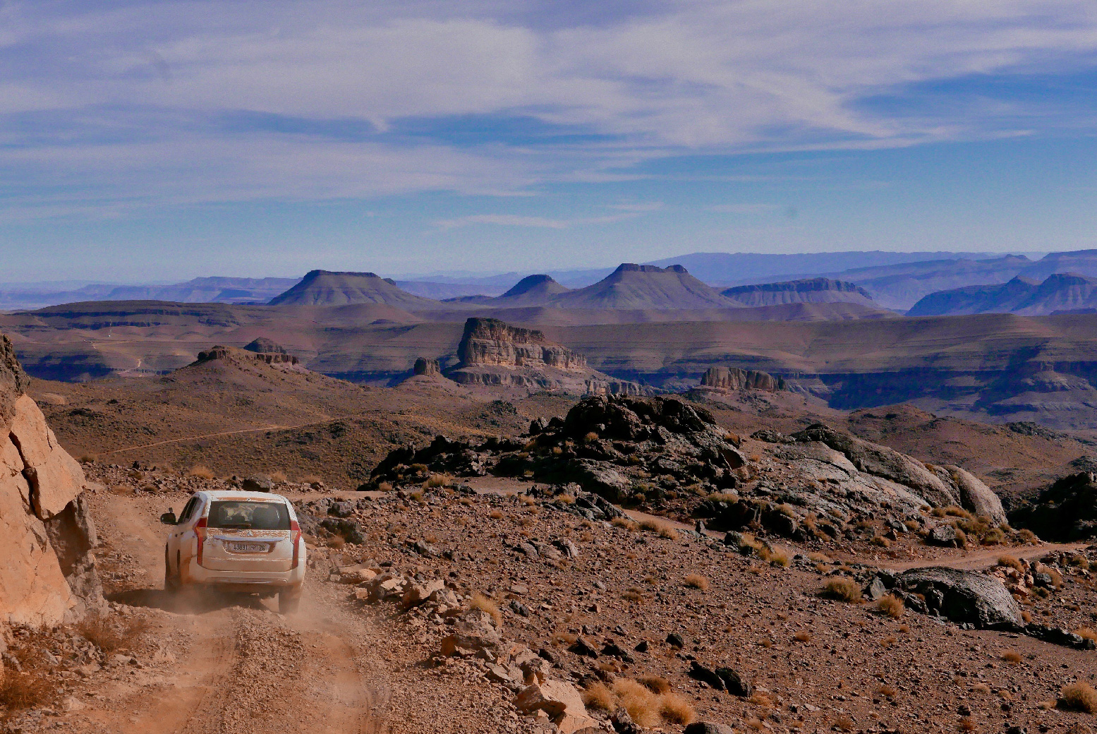
We drove some Sahara routes along the southern border I’ve not done in decades. I’ve now criss-crossed the ‘Black Rock Desert’ (left) with new routes and ideas for the next edition.
We came in from the north to join MS6 west of Remlia and, unlike last year when we nearly got stuck in the Duster on the clay pan of Lac Maider, this time our Prado bombed across past the Marabout- and Kem Kem auberges to the tyre marker. Here we turned south for Tagounite. All easy enough, but I can’t see me rushing back to do this southern section for another 25 years. Maybe more fun on a bike, but all round pretty boring and intermittently rough by Moroccan standards.
They still check your passport at the Pink Fort (KM187; below), but at KM195 I was surprised to find the crossing asphalted N to S. It comes in from the N12 east of Zagora via loads of farms, but from this point south appears to be restricted to the berm. It’s still a rough climb up to the Tefenna basin rim where various tracks cross to the other side and on to Tagounite.

Next day we drove Mhamid to Foum Zguid (also not done since 1998! Shame on me), this time combining MS7, 77 and 8 with sandy sections which wouldn’t suit a travel bike, until we reached the largely smooth expanse of Iriki. Viz was not great, but there was a track to follow SW on the Gaia Topo map. We then followed ‘777’ up into FZ for an OJ at Ibrahim’s by the roundabout. This was a fun, smooth and easy way of crossing this stage, but only in a 4×4 which needs some assertive driving immediately out of Mhamid. For sand-rut-free ideas for motos see this post and what follows.


We also ticked off the stage from Ouaouazaght to the Cathedral (left) and the Anergui bridge (MH16/18; tarmac ends there), and the last bit of MH10 through the Bougafer ranges and down into Alnif. Much more like it. Tarmac now reaches up to KM99, west of Imi n Izrou village.

Update 3.37 – February 2024
I rode the full length of MH1 the other day from Tounfit and from the state of the road, I will reclassify it as a piste in the new edition. Much of the road west to the Imilchil N12 junction is potholed or has lost its asphalt altogether (especially over 2200m). It would be gruelling in a van. At the Tounfit end they’re putting big new bridges in; maybe the start of a 100-km refurb?

The 2900-m Ouano pass has been freshly sealed 22km from Agoudal to the summit. From there, diggers are slowly working their way down the 16km to the Tilmi valley road along rough and not yet widened piste (pic), with thickly ground dust from the machinery. And from Tilmi, the road is pretty patchy for 21km until the MH3 Gorge to Gorge junction. We rode that too; now just 19km of easy piste between the roads coming in from each end.

Amazing to see Route ZR1 (Nekob – Skoura, 102km) deteriorating month by month for motos, as mining truck axles grind the bends into thick, deep powder and with no rain to wash it away.
We came back along part of the western arm to Tagmout, and every bend of consequence in now 6 inches + deep with bull dust. Even the col just west of Tagmout is thick with powder, and it’s not even a bend!
It’s more manageable than churned up soft sand or deep gravel, but still breaks the rhythm of a ride, having to paddle or wrestle the bike every few 100 metres. Shame, as the scenery is great up to KM70.
So we came out via MH14 north towards Kelaa – not done that one for years but a much nicer ride the flows all the way down. Did it again today going back in. Could be a better ride over Saghro, especially on a big bike with road tyres.
The first half of MZ1 is similarly dust bound, but the bends are wider and fewer.
In a car none of this is a problem of course, just loads of dust.
Also did the Kelaa-Tabant High Atlas crossing (MH19). A couple if kms dirt south of Ait Hamad pass with loose switchbacks.
And the same 10-km long dirt ascent from just after the ford to the top of Ait Imi pass.
Update 3.36 – Christmas 2023
I spent a week riding around Jebel Saghro, logging some fantastic new routes for the book, with a couple more days needed to sign it off. The boulder that was blocking the 9-km MH14-15 link track in February from the Aferdou basin up to MH15 has been released back into the wild and the track has re-opened to four-wheelers. Elsewhere, MH4 is now a road of course, but still a great southbound transit.
The amazing Saghro region will now get its own ‘ZR’- category and mapping in the 2024 edition.


I came up MH12 (RN23, old R307; p.129) Demnate road northbound from the N10 for the first time in years. As before, the tarmac gets worse and worse (but all easily drivable) as you near the 2190-m Tizi n Fedghate pass, the provincial boundary, whereupon you flip onto new, full-width bitumen.
This surface comes and goes between roadworks until I turned off west at Ait Tamlil (KM85) 28km later to follow a winding series of forest piste and backroads via the Moulay Youssef dam to Zerkten on the N9. Alongside the Demnate road a new column of pylons march northward from the Noor power plant.


This road widening (or maybe the earthquake) set off big rock falls and I passed one car which had slid off loose gravel into the cliff side. As with the N9 Tichka highway, ‘Ouarzazate’ province (Draa Tafilalet) lags behind on the job, though you’d think an ‘RN’ is government-, not province-funded.

Update 3.35 – Autumn 2023
Just back from 5 weeks in Morocco including 10 days of scouting new routes on the Honda, another 10 days doing the same in a Dacia Duster plus a couple of moto tours to pay for it all, taking in some new routes. For my new lodging impressions see this.
We drove the full length of MA3 (last ridden 2017); there is tarmac until KM76 after which a new shelf road has been cut into the valley side above the oued. It makes the route less demanding but at KM93, the next 5km to Ifesfas village are mostly in the oued, have an abandoned feel, and would not suit wide vehicles (width marker rocks are still in place). From Ifesfas the final 7km to the Haul Road block are more used. And from KM107.5 there is an amazing new road to (or actually bypassing) Timkyet and Afella. Annoyingly, the signs are still up for the gite at Igmir (MA2; all sealed) which was closed when I passed through in 2019 on the Himalayan.

We also drove part of MW2 along the Draa but coming in from a new road in the north and joining it at the gap at KM98. We left it 15km later (near below) to join a new tarmac road coming down from Jebel Rich and over the Draa from Aouinet Ighomane (MW3 KM133). Overall the condition of MW2 looked a lot improved, with fords installed (but some since ruined, left) so the full length may not be as rough as I suggest in the book.


A week or two later I rode the southern (harder) half of MH15 with a group of 310GSs. Only halfway up did I remember the last time I did it with a group I decided it was not a good idea. Everyone managed, but the climb is a bit rough in places, as well as exposed; still not a track to ride on a big bike clad in with a pair of 40-litre alloy panniers. It smooths off a bit after the link track down to MH14.
From the haul road (MZ1) we rode down to Nekob. Regular piles of trackside dirt suggests they’re planning something here, even though the track’s in good enough shape bar the very powdery bends (left). Interestingly, we did this as a day ride without our bags and the 310s and my 300L handled just like they were supposed to. Now I know. Lower-set baggage may be worth the added width.

Error. Book page 221, Route MW7, KM133.
Previous waypoint repeated.
Should be: 27.52342, -10.73592

I also notice on Google that they’ve built a berm (sand wall/ditch) to stop people wandering eastwards across the Chott Mezwat claypan on Route MW6 KM275. There’d be no incentive to wander east, it only leads towards various remote military installations and eventually the Big Berm border with the PFZ.

Update 3.34 – Western High Atlas earthquake
The September 8th earthquake whose epicentre at 3000 metres in the High Atlas and about 20km north of the 2903-m Tizi-n-Test pass, is said to have destroyed some 50,000 buildings and killed at least 3000 people, mostly mountain villagers.
Compared to the even more devastating flood which struck Derna in northeastern Libya just three days later, the relief response has been as good as can be expected, given the terrain and spread of the affected area.

How does this disaster affect the Morocco Overland user? Firstly, I would not cancel your trip to Morocco for fear of ‘getting in the way’ or depleting overwhelmed resources. The affected area is relatively small, with the Severe/Very strong dark reds on the map below just 100km across.
To most visitors the popular R203 Tizi n Test road linking Marrakech with the N10 for Taroudant or Taliouine passed less than 20km from the epicentre. For vehicle drivers this usually represents the first day out- or last day into Marrakech. In the early days towns along this route: Moulay Brahim, Asni, Ouirgane, Ijoukak and nearby Tatat n Yacoub (last fuel before the pass) featured heavily in grim news reports.
From Ijoukak (100km south of Marrakech) MH20 and MH21 trans-Atlas pistes (see below; Update 3.0.26) will have been affected. Traditional and precipitous stone and mud dwellings in the villages will be in ruins, and landslides or boulders have blocked the track as far away as Jebel Sirwa. The steep north side of little used MH20 coming north into Ijoukak is blocked and may be left that way.
East of this region and the MH6 Aoulouz-Agouim axis (including Jebel Sirwa), damage to tracks may be less severe and, where they connect to outlying villages, will have been cleared, even if the villages they reach may not all be in great shape.
For more on the quake and its repercussions as well as suggestions on where to make donations, see the HUBB thread.

Update 3.33
The MH7 piste section east of Askaoun has, initially at least, become a wide, graded haul road as well re-oriented at the eastern end thanks to the Zgounder silver mine just NE of Asakoun. The washed-out riverbed track through the narrow gorge at KM71 which saw me turn back in 2017 has been re-engineered for all weathers. But post-earthquake October 2023 read this.


It’s still a great piste with amazing views, interesting geology and grassy, alpine camping spots alongside trickling streams, just like the book says.
At fork 30.79037, -7.5914542 by some sheep pens (about KM100) keep left and continue downhill for 4km along the now more used route which passes above Amassin/e village to join the tarmac just north of the village by two village signs 30.81892, -7.57595. Turn right for Anezal.
Turning right at sheep pen fork is the old way by the book (p120), about the same distance to the road to KM104, but it looks no longer used by anything bigger than mules and light scooters. Askaoun to Amassine is now < 2 hours, plus another ~hour to Anezal.

There are changes to Route MS8 too. Heading north out of Askaoun follow new tarmac via Tazolt (auberge; only one for miles) and Taouyalte (misspelt ‘Taouyaot’ on p121). In another 5km the asphalt ends at 30.84894, -7.79103. Turn right here uphill (signed ‘Marrakech’) and you will pick up the MH8 original route without the sometimes tortuous navigation through the villages as in the book which are signed off the road before Taouyalte as photo left, but are not that interesting.
There are now conifers growing on the hillsides below the 2342-m pass (KM71.5; photo below) and from here north it’s by the book via the Limestone Pass to what are now three telecom masts at KM96 on the Aoulouz–Agium road to the N9.

I also reversed the westernmost section of MA12 (pink route, map p195) to Assaragh – my original moto tour route which I decided was getting too rough after various dramas. In fact lack of use has not made it much worse since the road was built to Assaragh from Agadir Melloul. It’s still a fun way of getting to or from Assaragh.


Update 3.32
February 2023 and a couple of weeks in 4x4s. My starting work on edition 4 in a Duster and a stack of new routes to explore was ill timed following a spell of snow and rain in early February. In ten days we had to turn back nearly 20 times from broken, blocked, flooded or otherwise damaged tracks and roads. For example, the road from Igherm to Tata is cut right about here and looks unlikely to be repaired soon. A mate on light bikes about ten days behind us had better luck getting through. We ticked off just five new routes barely totalling 300km.
Update 3.31
One reads it’s best not to tell the men in hats you have a paper map at the Ceuta-Morocco border. They may confiscate it as it shows ‘Western Sahara‘ (like just about every map, paper or otherwise).
Road-widening works creeping up the N9 from Marrakech, but not so much on the south side to Ozt (I rarely do this full transit of N9).
There’s a roadside fuel bowser in Zerkten in the N9 (20% over normal price) and they’re building a fuel station in Telouet.
MS14 Ouarzazate – Tazenacht now sealed
Looking for off road locations in this area, we blundered westwards down a track which I later realised was about a km after the turn off for Imidar (30.78954, -7.06621; Imidere on Google) but a separate parallel track to the south via no villages.
Nothing special, but we then came across MH9 from the south at a piste crossroads about 1.5km west of MS9 KM28.5 high point. We then turned west onto MH9.
I’ve not bothered re-doing this short route since I rode it in 2008 on an XT660Z, but as options lessen in this area it’s actually quite fun following the riverbeds in a 4×4; if not a not a full-dress GS12.

MA6
Did loads of scrapping and banging coming down this in the rental Prado TX (5kph for 2 hours), but I feel any deterioration has stabilised or is adequately repaired by passing 4×4 tourists. The tricky tributary crossings towards the bottom have improved, though once over the main oued you have to re-enter it around a wash out. The rest of the valley westwards is fine (in a car). Subsequent recces after I left the 4×4 group revealed loads more in this region south and west of Issil plain. Hope to explore them myself in February.
MH20
Update October 2023. From the north turn-off out of Ijoukak, this piste is now almost immediately blocked by earthquake debris impassable to a car or a big bike, with doubtless more blockages as the track ascends 8km steeply to Tizi n Oulaoune High atlas watershed (2200m). As it does not access any villages, repair here will be a low priority. The mast near the past could be accessed from the less steep south side from Ouneine.

MA9
They have finally started asphalting at the west end of the 53-km desert track to Tlite junction. Service tracks round the roadworks about 10-20km in have gotten a little feche-fechey from over-use, so a bit tricky for bikes.
MH15.2 as good as ever.
Loads more tourists around for what is normally a quiet time of year. Hottest November I’ve known, 30 end of the month in Marrakech. Cooler south of the Atlas.
Update 3.30
Insurance available again in Nador town for Melillia/Beni Ensar ferries. More here.

Update 3.0.29
And according to this post by a campervanner, it looks like the Ceuta-Morocco border is open again, and with AXA insurance in Fnideq too.
Route updates
The MH20/21 High Atlas crossing starts with a stiff climb (red route below) which can be a bit much for some. A new 12-km bypass (orange route below) is much easier. More here. Following the 2023 earthquake this bypass is open

MS1 Tafetchna
If you want, there’s only 14km of piste through the gorge from Tafetchna to Touna Niaraben where tarmac leads south 25km to Beni Zoli and a bridge over the Draa river course to the N9, 12km north of first Zagora fuel.
Updated 2024: all road now through Tafetchna gorge linking the Nekob to Zagora roads.


Kelaa/Boumalne Dades N10 bypass (41km)
At a roundabout about 35km west of Skoura, a new bypass cuts 41km south of the Dades river across the stony desert to another roundabout at the east end of Dades, by a Shell.
This route cuts across the northern ends of MH14/15 coming over Jebel Sarhro west (see new description below).
It’s a fast, traffic- and village-free alternative to the congested N10 around Kelaa. You can whizz through in less than half an hour. Google maps now try and route you onto this now and on this occasion, they’re right!
p113 • New ending to Routes MH14/15 (3km longer)

72 (25) N31° 04.06’ W06° 09.61’
Keep right (leave Olaf) onto a more used and direct track heading NW via villages. In 8km Olaf will join from the left. About 300m later go right at another mining haul road (KM80).
88 (8) N31°09.91’ W6°11.81’
Just after a righthand bend turn left (N) to meet the new Kelaa bypass (this wpt). Right here leads to Boumalne Dades (37km; ends by a Shell). For the nearest fuel go left 5km to the roundabout on the N10. Here left (west) is for Skoura (36km). Right leads 4km via villages to a …
97km N31° 11.83’ W06° 12.11’
… Ziz roadhouse. Several more fuel stations east towards Kelaa and Boumalne Dades.
Jebel Saghro East traverse ZR1
A reliably epic crossing of Jebel Saghro between Nekob and Skoura. It’s about 102km fuel-to-fuel. Full details here.

MH3 The once fashionably gnarly but imo much over-rated track between Msemrir and Tamtatouche (45km) is on the way to getting sealed. You do wonder why they’re bothering.
Yiorgos and Nikos write:
We did the MH3 gorge-to-gorge route from West (Tamtattouche) to East (Akedim Msemrir) [in September]. The beginning and ending of the road are under active construction. Road at these points is still dirt but is flat and wide (Be aware of heavy rains, they can create deep mud). The rest is gravel but easily doable with our [800GS] bikes.
There is a diversion of the road on the east end as so waypoint at MH3KM003 is outdated. Instead, according to my GPS, waypoint “31.71325° N, 5.80357° W” can be used, but – all in all – the track is visible with the eye.


MH1 Less surprisingly the exposed Agoudal – Tilmi High Atlas crossing (below) is getting the same treatment. That will be a shame, but it will still be an impressive route, peaking at nearly 3000 metres.
I rode it in February 2024: new blacktop all the way to the Ouano summit. From there, even at 6pm diggers (left) are working their away, hammering, scrapping and slowly widening the 16km all the way down to the auberge on the valley.

MS14 The 45km section of piste between Ouarzazate west and Tazenacht (via Fint turn off) is also now sealed.

Update 3.0.25
Route MH4 over Jebel Sarhro is now sealed, but it’s still a fantastic crossing of the massif.
Page 187-90, Route MA7
Route distance is 114km not 104.
The tarmac now extends to Amtezguine (KM56; p190)
The final waypoint should be 110 (4) and you’re 18km from Tazenacht, not 14km
Page 139, Route MH18, KM71 (169)
Distance error: KM78 (162) .
Distances either side are correct.
Update 3.0.24
Page 190, Route MA7, KM100 (4)
Distance error: KM110 (4) not KM100.
So it is 18km from the previous waypoint [KM92] where the tarmac resumes to the N10, not 8.
Update 3.0.23

There was also promising talk of a new ferry route between Portugal to get round the Spain-Morocco deadlock, but this seems to have gone quiet.
Update 3.0.22
Page 185, Route MA6, KM77 (85)
Waypoint error: N30° 07.7′ not N30° 07.07′…..
Update 3.0.21
The flood-prone trail through the gorge from. Anergui to the Cathedral (see Update 3.0.14 – 4 May 2019) is closed for improvement.
Update 3.0.20
I got down most of the Atlantic Route in March before Covid stopped play. See the report on the link or read about it in Bike magazine, July 2020 issue.

Below: the state of MH5 northbound late last year from 4×4 Adventure Tours.
Clearly a good place to flex those axles!
Update 3.0.19 – 2 February 2020
Jacinto V-H tells me:
Col Belkassem on ME7 is easy in both directions.
ME4 via Korima Pass to Bouarfa is now 40km improve piste, with the rest same as it was. I remember us struggling along this piste in our Merc 190.
MA7 up over Jebel Timouka is OK (better southbound) but MA6 south of the ‘Timouka’ pass is now unused and getting no easier.
Update 3.0.18 – 28 January 2020
I’m told there’s a new hotel in Smara (p222) – a town where the lodgings are pretty rough.
Hotel Sahariano is on the left coming into town after the roundabout and directly north of the airport, over the road.
There were always occasional turn backs by army checkpoints, but Ian C also tells me the west part of Route MS8 from KM216 towards Tata may now be a permanent military exclusion zone.
Update 3.0.17 – 12 November 2019
I am told the classic crossing of Jebel Sarhro (MH4) is now sealed.
Update 3.0.16 – 16 September 2019

The white immigration cards you used to fill out on arrival in Morocco have been dropped from today at airports in a bid to speed up immigration procedures.
They’re set to be dropped from maritime ports too in a month or two.
Update 3.0.15 – 13 May 2019
Ian C (KTM1290) writes:
We weren’t allowed out of [Nador] port without buying insurance there. The guy told us it was around 20 euros more expensive than in the town, but we had no choice, and it was all very official (AXA printed docs). Don’t remember exact price, maybe 140 euros for a month?
MS9 is now virtually abandoned, and included one rocky ascent and a lot of riding along a river bed. By contrast, MH7 continuing west from Anezal was a breeze, and a pleasure.
So MS9 is no longer a route to try on a big bike. Ian made some nice videos too, using a kite tied to some balloons.
MH19 going on to MH18 and the Anergui Gorge, as mentioned in the previous update.
MH13 – the Tangounsta Tunnel
Update 3.0.14 – 4 May 2019
Updates following a month’s ride out there.
Turning up at the counter in Algeciras, a month’s return with Balearia ferries was just €86.
The new credit-card sized TVIP at the port was issued in just 10 minutes (but I was first off the boat). You can’t do them online in advance any more.

MH16KM132 (MH18KM55): the track alongside the very narrow Assif Melloul gorge to/from Anergui is straight forward and a great ride. There are no ‘frail bridges’ that need to be crossed or avoided by fording the river. After the last hamlets, it gets slightly rougher and narrower at the eastern end where it gets close to river level, but nothing a 2WD with clearance couldn’t manage.
Coming north out of Anergui (a climb over 2500m) the newest fuel is in Tagelft (54km) or Imilchil (68km).

At the MH18KM132 junction the high road is now sealed and takes the old (longer) way down to the head of the Ait Bouguemeze valley where dirt resumes on and off.
MH18KM153. There is village fuel in the Ait Bouguemeze valley from a lock-up with a red door, 200m west of the police checkpoint junction where the tarmac starts at KM153 (and where MH19 goes south over the Atlas). Call the number on the red door; he’ll turn up eventually.

In fact, I am beginning to realise what may have been obvious: many remote villages accessible by cars but far from fuel stations will sell fuel from shops or lock-ups, and it won’t necessarily be dirty, diluted stuff and I’ve found prices a reasonable 10-15% more than a garage.
MH18KM183 From this col the southern loop climbs a bit more then drops down through villages, crosses an unfinished bridge and leads back north through a defile and the odd ford, then over a final col and a descent to a sealed road in the main MH18 valley. This option ons the main road a bit further west than the book suggests.
It’s all reasonably straightforward.


MH24 Amzeria (‘Amezri’ on some maps). On the MH12 High Atlas crossing, a side road over a bridge leading east of Tourfine (KM57; 1750m) ends in a few kms at a ford south for Megdaz (on Google). Carry on along a northside track to Ait Hamza. From here it can be tricky to access and locate the washed-out track in the stony Oued Tassaout riverbed, but it’s just about clear enough all the way to Ait Oubaten (or similar; <10km) where tarmac resumes to Amzeria. You then shoot back up to 2800m and wind your way down to Skoura. On a bike expect to get wet feet, as Dutch moto traveller Noraly S found in early 2023 riding this route westbound towards towards the Demnate road (video below).


It looked like they were extending what looked like a never finished track from Agdz north to Skoura via Bou Skour. For me it ended at the point below. More here.

The once gnarly 30-km section of track between Assaragh and Adadir Melloul on MA13 (the cover of Morocco Overland 2) has been sealed. It means the track on MA12 NW of Timdrart, KM139 to KM163 joining the road, may become obsolete and fall into disrepair/fun off-road challenge
North of Igli on MH6 KM77, a newish road leads west nearly 100km to Sidi Ouaziz back on the N10. The very highest section at around 2500m is now sealed making an epic high route (pictures). At a hairpin on the west side at 2250m (near picture below), it’s possible to follow a rough but Transit-able track 9km to KM23 on MH20. More pictures here.

The gite in Igmir (MA2) is closed. The next nearest place south was Bordj Biramane in Icht, a pricey but popular overlanders’ camp with a bar plus huts or tents.
The gite in Assa mentioned in the book on p210 was a nice place to stay, an authentic rustic, low-headroom adobe town house (below).


MW6 is now sealed all the way to Labouriat (KM126). From here a more used and corrugated track continues east towards Mseid. Don’t miss your turn-off at KM157, where the Dakar mounds commence. It means there is only about 150-km of easy to follow piste, but it’s enough.
Having finally ridden the full length of MW6 (with a 4×4), I’d reiterate it’s not a track to do alone on a big bike with road tyres, even if the 400-km range is not a problem.
Although this time I made less of a mess of the unrecognisably easy Oued Kara crossing at KM247, the dry sandy gorge at KM256 was a struggle on a fully-loaded bike, just as it was on the WR250R in 2017 when it was actually a waterhole (as evident in the Bing image below). A 4×4 can crawl across these sandy ruts, a bike either has to attack them (risky), or be paddled or walked through for a couple of hundred metres (tiring). I had to be pushed out, then once on the firms stuff (left) went over the stony hill (as I did on the WR) to get out on to the plateau before the drop to the chott.

If you need moto inner tubes in Layounne (including 21s), there’s a bike and scooter shop round about here, just south of the MacDonalds square.
Subsidised fuel in Western Sahara now seems to be the same price – 8 dh for diesel or petrol.
There’s some road building going on west of Fort Bou Jerif ruins, but the book description of MW8 from Sidi Ifni still stands.
Update 3.0.13 – 11 March 2019
Moto Plus in Casablanca. Probably miles from where you are but a good place to despatch motorbike tyres (and maybe other generic parts) cross country.
Update 3.0.12 – 23 Feb 2019
A recent video of MA6 so you know what you’re letting yourself in for.
Car and especially bike, definitely less hard southbound.
Update 3.0.12 – 15 Feb 2019
Thanks to David Q for pointing out two waypoint typos:
• MS2 KM77, east end of Ait Ouazik village should be: N30° 41.00′ W05° 37.59′
• MW7 KM81 and KM133 co-ordinates are duplicated. MW7 KM133, the fork for the short-cut to the SE should be: N27° 29.02′ W10° 38.53′
He also says ME8 out of Figuig via the new dam is getting sealed. The new routing is clear but may not match the book’s description.
Update 3.0.11 – 2 Jan 2019
The option to fill out and print your D16 TER temporary vehicle importation form online in advance has been dropped. They now issue you with a credit-card sized TVIP at the port – in my case just 10 minutes waiting.

Update 3.0.10 – 7 Dec 2018
Alternative road routes over Tizi n Tichka
Update 3.0.9 – 13 Nov 2018


A lot of rain in October has roughed up some southern pistes and the Tichka pass northside has more construction than last year as road-widening spreads down the mountainside. Whole sections of rocky hillside are being cut through to straighten the road, and in the rain the muddy old road could get slippery and slow.
On the south side of the pass, the road between Telouet and the N9 looks like it’s nearing completion, but is more disrupted than ever.
Coming down the cliff below Assaragh (MA12, MA13; right), they finished a sealed bypass around the west of Aguinan, but coming down it’s more fun to stay on the steep concreted track through Aguinan village and oasis.
It’s said the new road to Assaragh across the hills from Agadir Melloul will be finished in a few months which will means MA13 will ease up and MA12 from Timdrart village (KM139) back to the P1743 road at KM163 may well become disused and consequently unmaintained.


On MH4 Jebel Sarhro they say 20km out of Nekob is now sealed, but it’s hard to think the link to Iknioun tarmac will be completed soon.
On MH14 Sarhro West, ‘KM20’ start of climb just after a village is more like KM22.5.
Up to KM31 village down in the valley is easy enough on anything with wheels. Northward, as the book suggests, gets gnarly and may be becoming disused in favour of upper MH15
We crossed the oued at KM31 and second left took the link piste west to MH15, now called ‘MH145′ which I descended in a car about a year ago (see below).
Westbound, the 9-km climb is now toughest right at the start as it climbs steeply on a washed-out track below the butte. From there on it eases up bar the odd, short, washed-out climb. Amazing views when you get a chance to take your eyes off the track as it meets MH15 at KM69.
As expected, reversing MH15 southwards felt easier than climbing it, as I did in 2017 on a WR250, but has become more washed out. A beginner wouldn’t want to do this little-used-track alone on a big bike with alloy panniers bashing off the sides and shoving you over the edge. Below: exposed descent (southbound) around KM48.

As the descent ends to meet the valley track at KM42, the sandy ramp side valley has filled right up with loose sand. Again, heading northbound on a big loaded bike, this might be a bit of a shock and would require a good run up in a 2WD.
It’s possible that the high-altitude hamlets get serviced from the north along the improved mine haul road so this dramatic section of MH15 has now become one of the harder pistes in the book.

Update 3.0.8 – 26 Oct 2018
At the very last minute Morocco has decided to not put the clocks back an hour for winter. It will now stick with GMT+1, all year.
What that means for most of us who visit the south during the winter period is chillier mornings and longer evenings. The EU has talked of introducing similar changes.

The rational behind clock changing makes more sense the further you are from the equator. Daylight in Dundee varies by over 10 hours over the year, but in Ouarzazate it’s only about 4. Most of the world does not change its clocks twice a year.

Update 3.0.7 – 25 April 2018
New route: MH20 High Atlas crossing.
Update 3.0.6 – 2 April 2018
Insurance at Nador port seems to be available again.
Update 3.0.5 – 28 February 2018
A few tips on campervan insurance if you don’t feel confident in buying border insurance. Also, extending your Moroccan insurance can be tricky in the country:
Warning: Although the visa extension was easier than reports on the web, extending our vehicle insurance was not.
There are assurance offices in most large towns, but they will only do Moroccan registered vehicles. That includes AXA. The frontiers insurance seems to be a monopoly with CAT Compangie D’assurance Transport based in Cassablanca. They have relatively few agents and you have to visit the agencies in person to get a new assurance certificate.
It cost us 1952 D for 3 more months (the same as at the border).
And contrary to what I thought, I’m told Bike Sure-Adrian Flux can issue Green Cards for Morocco.
Update 3.0.4 – 18 January 2018

Brittany Ferries announce a new ferry route between Cork and Santander – 26 hours each way, twice a week from April to November.
More here.

New route MS777 (right) from Fred W; a smoother way to or from Foum Zguid to Lac iriki via MS8. Download the pdf route description.
Update 3.0.3 – 9 January 2018
MS8 – correction/updates
Belgian travellers Fred and Jo (contributors to my other books) observe:

… the initial route description [out of Mhamid] makes it quite a bit more difficult then it ought to be … it sure keeps you busy and makes it more adventurous. The zigzagging between the dunes can be avoided by following the main trail right out of the village to the south for Erg Chegaga which makes a big curve under all the messy bits. It is drawn (more or less) like this on most GPS maps (eg: left). It then picks up the described route again close to Erg Chegaga [KM75]. This is the route as given to us by a local guy so it is relatively well travelled and thus quite easy to follow.
There is an additional checkpoint around KM181, just before the oued crossing and ‘chicane’.
Possibly as a result of flooding KM204 will better read now:
KM205 (109) Cross the Oued Mellah at an army checkpoint: N29 39.62 W07 12.02
We are probably not the first ones to be confused there, as there were already tracks leading from the KM204 waypoint straight into the oued… If you do cross here you will come to a halt shortly by a lot of water followed by an unsurmountable ridge.
Western Sahara map
Revised with new road north of Bir Anzerane. May link up with Bou Craa road eventually.
Update 3.0.2 – 26 December 2017
‘MH19’ southbound added
See this.
MH4 KM0–57 – correction/update
Now all sealed through to Iknioun. At KM0 (Shell/Afriquia) continue 800m SW to the next roundabout, then turn SW.
At KM3 fork, right is for Ouaklim village; left then turning right (SSW) at KM7 avoids the village. Both routes join up at KM11. From here all clear to Iknioun.
Within a year they say the classic MH4 may be sealed to bring in electricity pylons from Nour solar plant. Hard to believe, but in late 2017 the approach to Nekob was already a dirt motorway.
MH14 KM72 – correction
Turn right off Olaf… I always get those two mixed up!
MH145 link route
In December we did the 9-km link route down from MH15 KM69 to MH14 KM31.
The impressive 500-m decent (below) is doable from either end in any vehicle that has managed to get this far.


MS77
We did MS77 in the same rental 4×4 pictured above. Expecting the worst, I have to say it was much less rocky than decribed, but the Mitsubishi was softly spring. I doubt an old HJ60 would have been such a magic carpet.
Around KM44, before converging with MS7, things got quite sandy and rutty (left); fun in a car, less so on a loaded moto with road tyres.
Before KM72 the main track seems to bypass the dunes mentioned, so that’s not an issue. Then, heading NW then W after the desert camps is more sandy ruts. Again, fun in a fourbie, but would require commitment and knobblies on a bike.
Update 3.0.1 – 20 October 2017
Marrakech airport arrivals
With the flash new terminal at Marrakech Menara airport, the grubby old #19 ALSA bus stand is now a couple of hundreds metres away from the exit. 20 one way, 30dh return.
Insurance at Beni Enzar/Nador
No longer close to the Melilla border, as on the map p54.
Now 12-km away in Nador town: see new map here.
MH4
Once you leave the road [KM57] the piste is a bit washed out than usual towards the summit.
Over the summit initially rough as usual. A new road is working its way up from Nekob with some diversions.
‘MH19’ (not in the book)
In good shape; see this.
MA7
It’s now asphalt to Amtezguine [KM56], but from there the climb gets quite rocky and washed out for about 10km until the first hamlet at the northern, near the mast. On a big bike I’d say southbound is easier.
MA13
I’m told they will be sealing the middle section between Agadir Melloul [KM105] and Assaragh [KM137], but I imagine that may take a while.


Pingback: Morocco ~ Routes | Sahara Overland
Pingback: ‘A’ if for Atlantic Highway | Sahara Overland
Pingback: MH23 – New Jebel Saghro crossing | Sahara Overland
Pingback: Morocco Maps | Sahara Overland
Pingback: Map review: Reise Know-How Morocco 1:1m (2023) | Sahara Overland
Pingback: How to trace and save a GPS tracklog online | Sahara Overland