
Updated November 2025
See also:
Atlantic Highway
The Dig Tree
Trans-Sahara Routes
Tindouf piste
2017 report from the area
The N1 Atlantic Highway down the coast of ‘Western Sahara’ to Mauritania is straightforward and safe and essentially a continuation of Morocco with more frequent checkpoints. More here.
Many current maps, not least Google Maps, (but only when viewed outside of Morocco) identify a territory called ‘Western Sahara’. The dashed border along its northern edge gives a hint that there is no actual country called ‘Western Sahara‘.
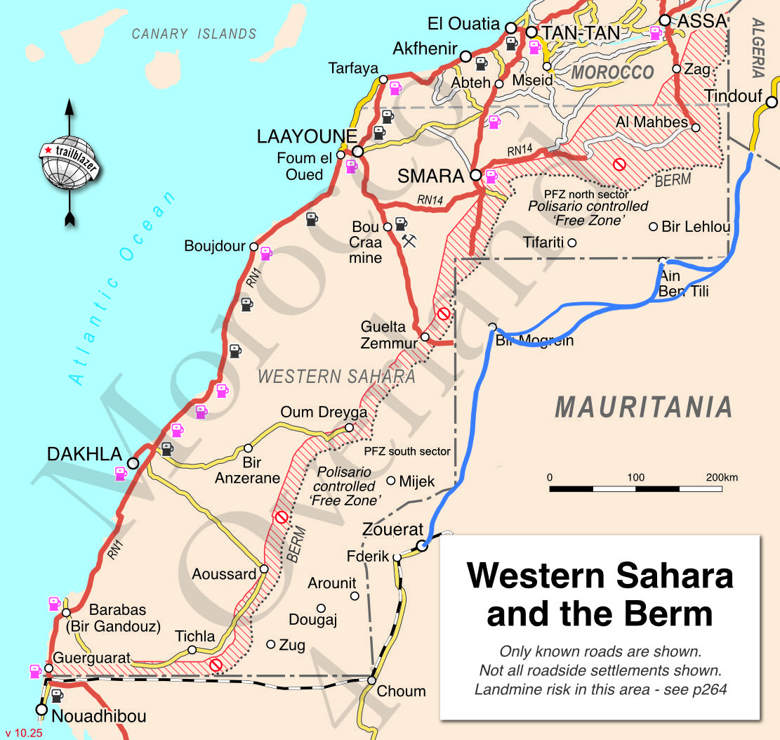
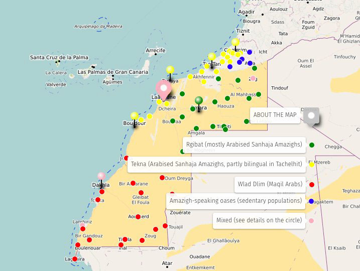
The map above is based on my Morocco Overland 4 guidebook and shows how this area currently breaks down in real life.

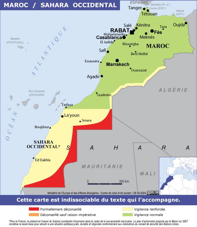
In late 2020, just before the US election, the Trump administration took the step of being the first western country to recognise Moroccan sovereignty over its entire ‘Western Saharan’ territory. As of September 2021 the State Department map depicted ‘Greater Morocco’ (left). So briefly did the BBC, until they changed it back quick. In 2022 Spain, the region’s former colonial power, followed the US’s steps, and so did France in summer 2024. And in October 2025 the UN finally acceded to accepting Morocco’s 2007 ‘Autonomy Plan‘ for one year as the best solution to reuniting the territory.

Many maps (right) are misleading as they fail to identify the 2000-km long Berm (shown on my map above; more below) which is the de facto border between Moroccan territory to the west and the Polisario Free Zone of the SADR to the east.
What does this all mean to the desert traveller?
You can easily travel down the all-sealed N1 Atlantic Route in Moroccan-controlled territory to Mauritania with no problems bar a few checkpoints and where a fiche (click to download template) is handy. Fuel is discounted south of Tan-Tan and fuel stations are frequent enough in the desert between the main towns of Laayoune and Dakhla. However, despite what some current maps may suggest, the heavily militarised Berm is not going away any time soon. Get too near it – ~30km – and the army will send you back or you may hit a landmine. Stick to the west side.
Origins of ‘Western Sahara’

The former colony of Spanish Sahara, (left) was relinquished by Spain in favour of Morocco and Mauritania in 1975. This was against the wishes of the indigenous Saharawi (‘Saharans’) population and their Polisario Front which had been agitating for independence since the 1960s. A few months later the Saharawi Arab Democratic Republic (SADR) was declared by the Polisario.
Michael Mercer’s 1975 book, Spanish Sahara describes the region’s geography and history, and Skeletons on the Zahara is another good read set in the area. John Lodwick’s pompous and convoluted The Forbidden Coast (1956), less so.
By 1979 Morocco had annexed the resource-rich west of the territory to which it had long made claims. As a result of that, a war broke out with Algeria (allied with Mauritania for a while) who both claimed to support the Saharawi and the SADR.

In 1991 the UN brokered a ceasefire and a plans for a referendum to decide the future of the territory. MINURSO bases are still dotted around the territory (a 2021 MINURSO map). But by this time Morocco had populated its part of the territory with northern Moroccans so as to win any referendum which has been repeatedly postponed since then. Laayoune today has a population of some 200,000, most of them northerners benefitting from ‘frontier territory’ subsidies and other inducements.

In the meantime Morocco began building a series of defensive berms, spreading in successive waves further south (above; fanack; good info here), until by 1987 the current 1500-km long militarised wall or Berm divided the territory longitudinally, like a modern Great Wall of China.
The Atlantic side – two-thirds of the territory – are known in Morocco as the Southern Provinces. East of the Berm as far as the Mauritanian border is the Polisario Free Zone (PFZ), barely developed, far less occupied and supported by Algeria which also hosts many Saharawi refugee camps over the border around nearby Tindouf. If Morocco’s autonomy plan succeeds in unifying the Western Sahara (ie: incorporating the PFZ), unravelling all this defensive infrastructure will be a whole lot of work.
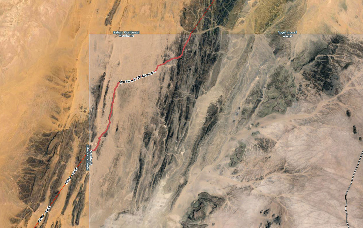
From Google maps you can see the Berm cuts a corner off northwest Mauritania for about 50km (left), so dividing the PFZ into two regions. Not all maps displayed on this page accurately show this delineation, and who knows if this is a former ‘forward line’ of the Berm which is currently unmanned. It is almost certainly mined.
In 2025 this break in the Berm has enable the completion of RN17B road from Smara south the the Mauritania border. More about that here.
prior to that the break forced the Saharawi of the PFZ to cut across Mauritanian territory in the vicinity of Bir Mogrein when they wanted to get from the Saharawi camps near Tindouf (Alg) where the SADR administrative body sits, to the less populated southern sector of the PFZ. One can speculate that Mauritania tolerates these transits as long as the non-Mauritanian Saharawi (also ethnically Moors) stay north of a certain area. Further south one hears the latitudinal ‘railway border’ between the PFZ and Mauritania is respected by the army and police of both sides, although it’s said Saharawi nomads seasonally pass over the border and back.
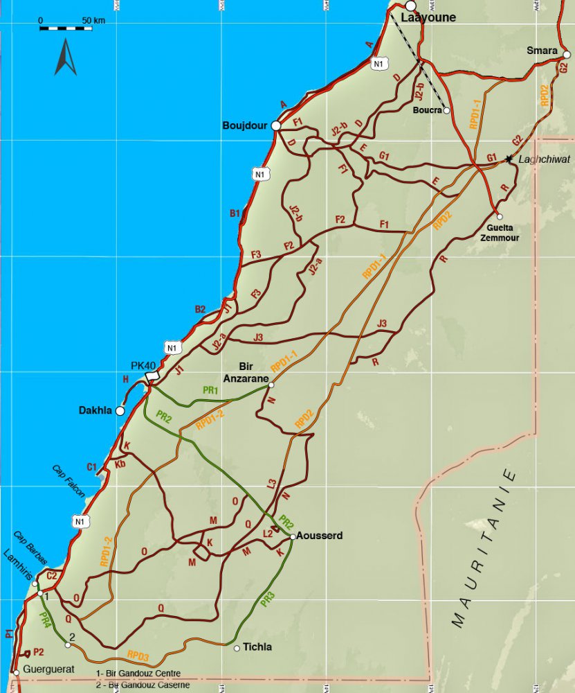

Inland travel from the coast is much less common. A couple of roads and pistes lead to mines, small Saharawi settlements and Moroccan military bases embedded along the landmined and patrolled Berm. Zoom in with Google sat and you can see these installations clearly.
We travelled in this area in 2019 (below; well away from the Berm) and there’s even a French guidebook listing routes (above right). But the rather dull landscape and risk of landmines when away from well-used pistes (particularly in the south) puts people off. See this, summarised in the box, left.

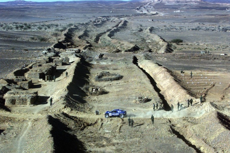
The Dakar Rally (below) used to run from Smara or Guelta Zemmour in Morocco, (possibly briefly across the PFZ) and into northern Mauritania. But since at least 2002 tourists cannot cross the Berm – and when they could they did so with least difficulty along the main piste linking Guelta Zemmour with Bir Mogrein. In 2025 it is said this will become a new official Mauritanian border, along with ’17B’ south of Smara.
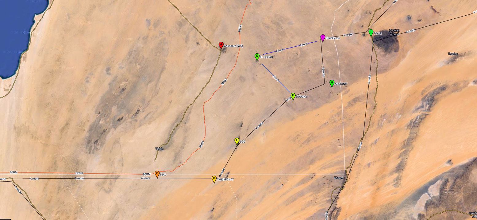
Years ago a couple of travellers traversed the PFZ’s southeast corner which is used by locals as a shortcut between Nouadhibou and Zouerat to avoid the Azzefal dunes (left). But as a foreigner, once noticed or arriving at Zug, you may be escorted via a couple of UN-bases northeast to Arounit, close to the Mauritanian border and south of Zouerat.
In the PFZ you may find Spanish more commonly spoken than French, and it’s said you can get by with no visa or invitation letter, use Mauritanian ouguiya and buy cheap Algerian fuel.

Pingback: Security Situation Western Sahara / Mauritania - Page 2 - Horizons Unlimited - The HUBB
Pingback: ‘O’ is for Old Sahara Maps | Sahara Overland
Pingback: The Algerian Berm | Sahara Overland
Pingback: The mysterious Tour de Merkala | Sahara Overland
Pingback: Sahara – The Empty Quarter – Part I – Overlanders' Handbook
Pingback: ‘A’ if for Atlantic Highway | Sahara Overland
Pingback: Maps of the Sahara | Sahara Overland
Pingback: Trump claims Israel-Morocco deal brings peace, but in reality it could spark war – All Sides Now
Pingback: Israel-Morocco deal is Trump’s latest distortion. And it could bring war, not peace. – scriptori
Pingback: Morocco ~ Documents and port immigration | Sahara Overland
Pingback: Morocco Maps | Sahara Overland
Pingback: Map review: Reise Know-How Morocco 1:1m (2023) | Sahara Overland
Pingback: Mauritania: The Railway Piste (440km) | Sahara Overland