Siân Pritchard-Jones and Bob Gibbons
As an overland driver during the late seventies and early eighties, Bob drove across the Sahara four times en route to Kenya and Johannesburg and became fascinated by the variety, colour and people of the desert. On one trip, in 1978, he visited N’djamena, but that was as far as he got. It’s taken a long time to return, but the fabulous landscapes and mystery of unknown Chad did not disappoint.
Perhaps the most difficult thing about trying to visit Chad is finding enough like-minded people to fill the absolute minimum of two cars. (Three would be wiser &emdash; there is virtually no traffic anywhere). Our trip only came together with less than two weeks notice and planning time, although we had been desperately holding on to a provisional air booking to N’djamena. We had been contacting a couple of agents in N’djamena since 1997, and again in 2001, so it was quite a shock when one agent found three other participants and agreed to do the trip for five people. The director, Moussa, then informed us he would be in Mecca on the annual Haj at the time of our trip, but no problem!
We flew to Chad from Paris on Air France at a very reasonable price and used some Air Miles to get to Paris. Luckily the agent in Chad had said he was able to sort out our visas on arrival. Nobody questioned our hurriedly faxed invitation papers from Chad at the Paris check-in, though it was certainly with some trepidation that we landed in N’djamena, visa-less and clutching tacky bits of paper called documentation. But a man was there to meet us! And the visas were sorted out the next morning.
Our travelling companions were all French. Thierry and Christophe both worked at the French school in N’djamena. Our third French member, Marie-France, had a daughter and son-in-law working in Chad. They had also only very recently signed up for the trip, which the agent had decided to promote after our repeated requests.
Our first three days followed the well-worn piste through Moussoro, across the dusty Bahr el Ghazal and into the sands of the Erg du Djourab dunes. Bypassing all the main settlements after Moussoro meant we avoided unnecessary hassles and demands for money from bored, underpaid officials. However there were plenty of nomadic herders, camels and goats before Koro Toro, where the short fine yellow-coloured grasses of the dry savannah gave way to true desert. Here among the dunes we met one of the heavily-laden trucks loaded with Africans bound for Libya in search of a better life; unfortunately the truck had a very sorry-looking set of battery leads and had been stuck for three days. We took one of the driver’s mates on to Faya to get help.A fiery sunset marked our arrival at the oasis of Faya, in a spectacular setting below the rugged escarpments and outlying crags of the Tibesti. At dawn we set off to explore the oasis, before the guides suggested we shouldn’t wander about on our own. With a fairly reticent population, we suppose they need to be a little cautious and we ourselves were careful not to offend with our cameras. However we did encounter some friendly curiosity. We camped in the grounds of the appropriately-named Emi Koussi hotel, with bucket showers and bags of run-down decaying atmosphere.
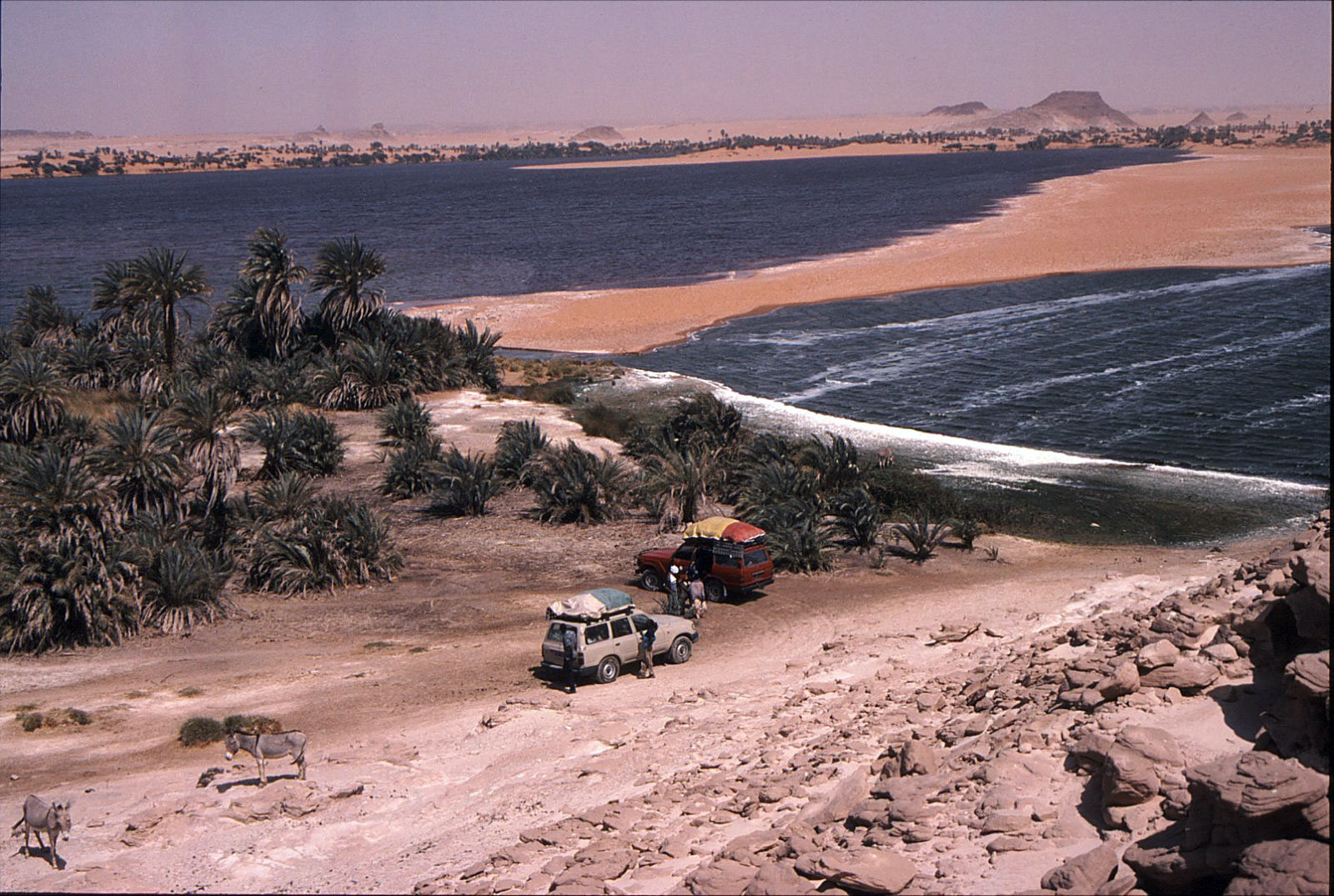
From Faya we were surprised not to be taking the direct route to Ounianga Kebir, close to the Tibesti. We headed generally southeast and made a large loop, later heading north and then northwest to within five kilometres of the Wadi Doum military camps and oasis. We were told that rebel activity in the Tibesti, although curtailed since the new ceasefire, had resulted in a lot of mines still remaining along that route. In Ounianga Kebir we visited the fantastic lake and heard first-hand accounts of the trouble caused by mines. We met a young man from Cameroon who had recently arrived there. His truck had driven over a mine, resulting in a few deaths and some bad injuries not far from the oasis. In good spirits, he was still hoping to continue his journey northwards when he had earned sufficient money to pay his fare.
On leaving Ounianga Kebir, we were therefore somewhat concerned when the GPS readings indicated we were heading northeast and not east for Ounianga Serir. Somehow in the poor visibility we had missed the ill-defined piste, and were heading towards Libya across some very nasty sand loaded with fractured boulders and very sharp debris. Not much point in worrying by now. Eventually we dropped off the escarpment down a fantastic sandy corridor between dark rugged crags and towers. Back on track, we soon arrived in Ounianga Serir, where the different lakes were if anything more spectacular. The most easterly lake was a gem, ringed by orange dunes, bright green reeds and multicoloured rock outcrops. A truly stunning place. Our camp on the sandy rocky area high above and just south of the lakes was another spectacular spot to wander at sunset, watching the red and orange shades of the rocky towers become deeper and deeper, before finally fading away into the evening light.
From Ounianga Serir we headed southeast into the region of the Depression de Mourdi, hoping to take a track directly from the north into the Ennedi to Fada. En route we visited another superb lake below an escarpment at Tegguidei, a place not shown on any of our maps. Here a small transient population mine white salt beside the lake, surviving on just one tiny mosquito-infested pool of fresh water. Nobody was here in early March, but we saw the grain stores and evidence of recent visitors.Just after the lake we became hopelessly bogged in deep orange sand below a jagged black spire of rock. Travelling on southeast we reached Demi, another small settlement, again set below spectacular outcrops. Here a very reticent and unfriendly population ekes out a poor existence, mining red rock salt. The people claim to be not Tubu but Gorane, and absolutely refused to let anyone even so much as get a camera out.
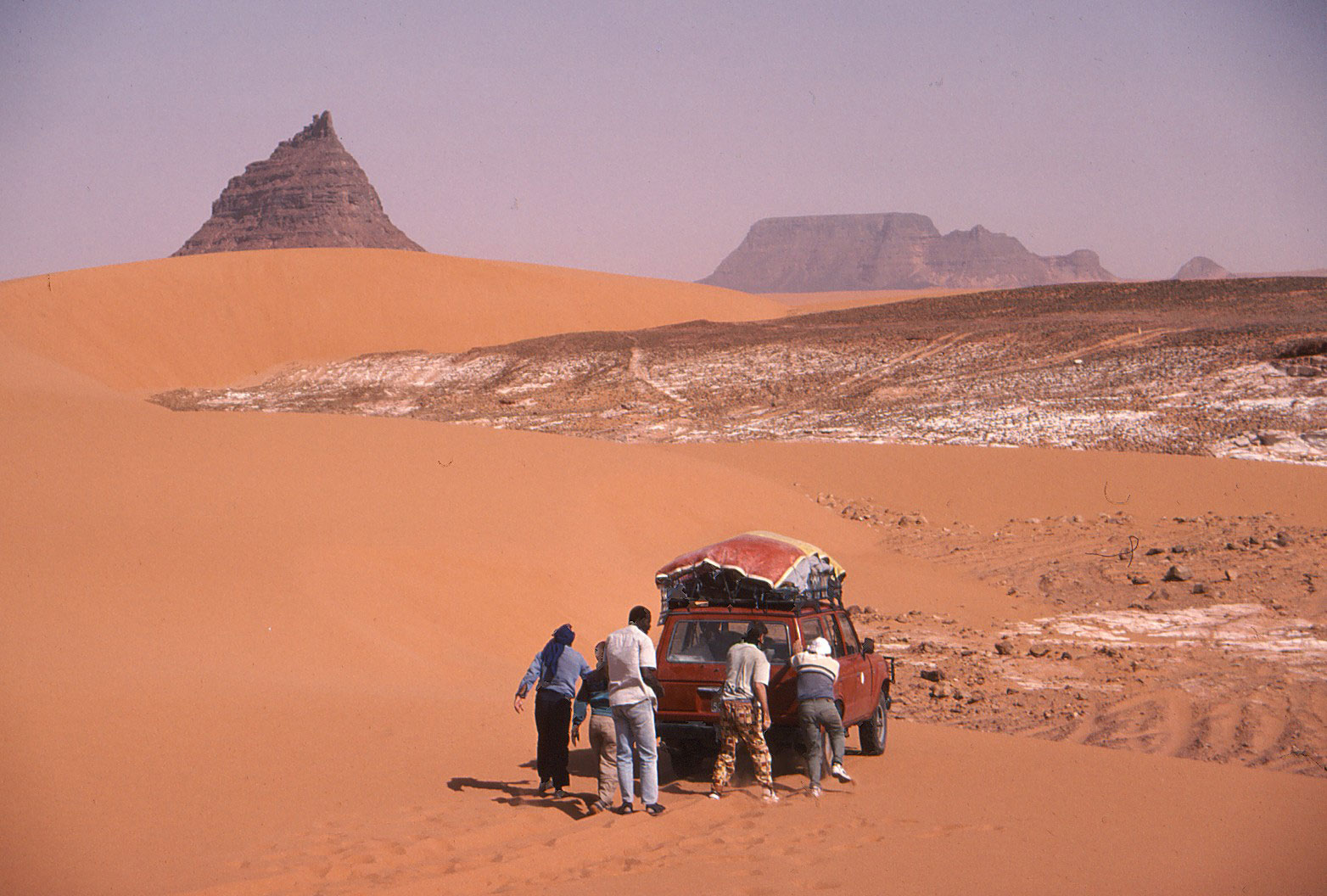
From Demi there were absolutely no vehicle tracks and no piste; we were just heading vaguely south and southwest across the most tortuous terrain. A mixture of sand and broken rocks, low crags and dunes constantly blocked the way forward, necessitating some backtracking, diversions and some truly skilful driving. A careless driving mistake in this terrain would have very serious consequences. Indeed at one point in the middle of nowhere we came across an abandoned fully-loaded old Toyota, complete with sacks of grain and a guerba on the side. But there was no sign of human life. Had it been recently left there while the driver went for help? We will never know…
All the next day a raging hot wind blew, with heavy stifling clouds and very poor visibility. Occasionally rain fell as huge droplets of sand-filled water, leaving thick opaque spots on the side windows and windscreen. In the distance we could make out the silhouette of the northern cliffs of the Ennedi, with finger-like towers and broken outcrops where the plateau has eroded. Here we met a solitary overloaded vehicle coming from an oasis deep in the Depression de Mourdi. They advised us not to continue to Fada by this route, as it could take two or three days via a rocky track, so we retreated westerly.
A vague piste eventually led us down an amazing sandy corridor of dunes and rocky towers that marked the western edge of the Ennedi. The scene was quite surreal in the yellow hazy light of the storm. We stopped briefly at Wadi Wei, an isolated well with acacias and tamarisk trees. From here to Fada the scenery was dominated by rocky towering outcrops and quite hilly areas of sand piled against the rocks. It was dark by the time we approached Fada, and somewhat intimidating to drive through the narrow gorge surrounded by minefields, marked by large signs, barrels, tyres and wire. (These mines are currently being removed, so hopefully it should soon be much safer.) As we came closer to Fada, some military vehicles shot out of the bush to check us out, but we soon arrived in the mud-brick settlement. Our camp was in the courtyard of a house belonging to a relative of one of our drivers, at the eastern end of the village.
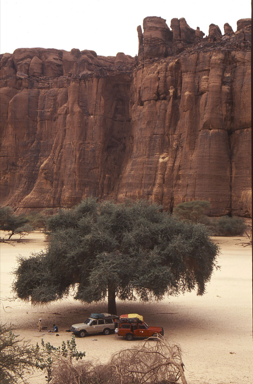
South and east of Fada lies the spectacularly and justifiably famed scenery of the Ennedi. Here are the fiery red rock walls and canyons, rock towers, rock art and other amazing erosion features which are being slowly engulfed by sand and dunes. We camped of course in the Guelta d’Archei! Here the canyon walls provided an eerie watch in the moonlight. Every day the goats and camels of the herders come to water at the black turgid pools of the canyon, in a riot of confusion. During our visit some goats had become trapped on the steep vertical cliffs of the canyon and we spent a somewhat sleepless night listening to their tortured cries. Sadly a couple had already fallen to their deaths, but the rest performed amazing feats of mountaineering and communications in their attempts to escape the clutches of the forbidding cliffs. Alas the famous dwarf crocodiles remained elusive, but tracks and droppings gave some indication of their unseen activities.
In the morning we trekked for a couple of hours each way to the north side of the pools to a high vantage point overlooking the guelta and the canyon, which is at its most spectacular from this point. It is also far enough away from the herders to take pictures of the camels watering, pictures which were vehemently resisted down at the pools. (Though when they saw us up on the cliffs, they walked out into the black waters to draw their camels back out of sight!)
The rest of the time in the Ennedi was spent exploring the many canyons and some amazing natural rock arches, as well as visiting some excellent rock art sites. The paintings here are certainly to be considered the equal of those in the Tassili n’Ajjer around Tamrit and Sefar in Algeria.
The last three days of the trip took us south to the village of Kalait, shown on some maps as Oum Chalouba or thereabouts. Then we turned west across the scrub to Kouba and back to N’djamena the same way. We had hoped to return to the capital via Biltine and Abeche, but the route is said to be bad and time-consuming after Abeche on the main road. Most traffic appears to be going further south from Abeche through Mongo to N’djamena.
Just one hour before our flight back, we had an urgent phone call from Moussa, who was very keen to meet us; he had been delayed in Addis Ababa for two days on his return from Saudi Arabia.
All in all it was a fabulous trip, and we are now keenly waiting for the Tibesti to be cleared of mines and re-opened… maybe in two years.
Notes: Our papers were checked in Moussoro, Faya, Fada and Kalait. We refuelled in Faya, Ounianga, Fada and Kalait on the trip – all from barrels. Most food was brought with us from N’djamena, but occasionally bread and fresh chickens were purchased in the villages.
CHAD: OUNIANGA – ENNEDI – GPS READINGS
N’djamena N 12º 06.534 E 15º 02.814
306km – Erg – N 16º 37.716 E 18º 42.238 – sand dunes en route to Faya
Faya – N 17º 56.155 E 19º 06.723
Lunch 4 – N 17º 51.415 E 19º 55.672 SE of Faya
401km – N 18º 02.487 E 20º 07.240
402km – N 18º 09.505 E 20º 16.878
Wadi Doum – N 18º 22.609 E 20º 27.652 – view of Wadi Doum, app. 5 km to west – military camp best avoided
403km – N 18º 31.653 E 20º 25.090
Camp 4 – N 18º 42.907 E 20º 21.003
501km – N 18º 46.472 E 20º 22.181
Ounianga Kebir – N 19º 03.314 E 20º 29.544 – village, water, fuel, large lake
507km – N 18º 54.572 E 20º 45.480 – interesting canyon N of piste
Ounianga Serir – N 18º 54.823 E 20º 52.561 lakes
Oun Ser Lake – 2 N 18º 54.888 E 20º 54.619 – another smaller lake
Camp 5 – N 18º 53.917 E 20º 55.449
Teggedei – N 18º 51.605 E 21º 23.196 – salt mine, lake, also date palms no permanent habitation – mosquitoes
605km – N 18º 46.520 E 21º 40.035 – pointed outcrops
Demi – N 18º 45.904 E 21º 40.334 – salt in earth, village
608km – N 18º 41.398 E 21º 42.571 – view of large u-shaped gap in mountains
Camp 6 – N 18º 05.273 E 21º 11.053 – below small dune
713km – N 17º 46.400 E 20º 55.253 – spectacular rocks
Wadi Wei – N 17º 31.349 E 21º 01.375 – water hole
716km – N 17º 16.203 E 21º 13.624 – minefield marked after here
Wadi Inu – N 17º 12.213 E 21º 23.125 – vegetated wadi
Fada – N 17º 11.106 E 21º 35.245 – minefield at entrance to town, marked now being clearedGuelta d’Archei – N 16º 53.964 E 21º 46.607
902km Paintings – N 16º 51.269 E 21º 48.361
903 Arch – N 16º 48.873 E 21º 50.965
904km Well – N 16º 48.617 E 21º 52.410
905km – N 16º 47.502 E 21º 51.668
906km – Arch N 16º 46.280 E 21º 49.944
907km Archkm – N 16º 45.630 E 21º 50.541
908km – Tower N 16º 44.043 E 21º 50.575 rocky tower
Tokou – N 16º 45.299 E 21º 48.301 well
910km Paintings N 16º 44.318 E 21º 42.157
Camp 9 – N 16º 44.342 E 21º 42.374 superb camp site in all respects
1002km Arch – N 16º 43.007 E 21º 40.378
1003km Military – N 16º 43.893 E 21º 38.165 military hardware lying around
1004km Arch/Paint – N 16º 44.199 E 21º 37.574
Deli – N 16º 50.272 E 21º 27.729 spring; not much water
1005km Paintings – N 16º 50.678 E 21º 27.519
1006km Tower – N 16º 49.616 E 21º 20.617
1007km Road – N 16º 48.523 E 21º 16.436 main piste from Fada to Abeche
Kalait – N 15º 50.358 E 20º 53.678 village; water, fuel
Oum Chalouba – N 15º 48.134 E 20º 46.230 military camp
Pirtodi – N 15º 56.306 E 19º 25.199 very deep well, camels
1105km – N 15º 48.419 E 18º 42.236 hard to follow piste round here
1108km – N 15º 49.335 E 18º 23.168 main piste to Faya
Kouba – N 15º 44.906 E 18º 17.892
Salal – N 14º 50.640 E 17º 13.578
Gosbela – N 14º 04.674 E 16º 32.384
Moussoro – N 13º 40.086 E 16º 29.627 west of Moussoro
Kouri – Kouri N 13º 40.309 E 16º 12.754
Chedra – N 13º 26.619 E 16º 02.732
1202km Well – N 13º 22.700 E 16º 00.399
Massakory – N 13º 00.354 E 15º 44.685
Massaguet – N 12º 29.051 E 15º 25.058
Djermaya – N 12º 23.694 E 15º 03.152
N’djamena – N 12º 06.534 E 15º 02.814
Discover more from Sahara Overland
Subscribe to get the latest posts sent to your email.
