![]()
Updated January 2026
E-visas introduced 2025. No more Visa on Arrival but you still pay €55 at the border.
Tindouf route from Algeria.
Railway Piste inland to Choum
Money
Mauritanian ouguiya exchange rates about 43 to ¢1. You might buy it black market at the Moroccan border post or officially at the border/airports.
Price and availability of fuel
Availability and prices vary by location and petrol can be scarce. If the fuel station runs out there will be a dirty roadside drum, but at up to four times the price.
Petrol from €1.25 a litre
World fuel prices.
Chami on the N2 highway less than 200km from Nouadhibou and 270km from NKT has a station with another 13km south of town.Both can run out of petrol so fill up when you can or pay up to 200 oogs a litre from a drum.
Costs
Moderate but expect price gouging where opportunities arise. New laws require a residency card to buy a SIM card, clearly not possible for foreigners without local help.
Useful languages
French, Arabic (Hassaniya).
E-visas
No more visas on arrival, but it is best to print out your e-visa for the border, even if there is a QR code.
The official online form states: Please upload a supporting document for your e-visa application (invitation letter, certificate, or any other relevant document.
Applicants have found attaching an itinerary including details of hotel stays in Nouadhibou and Nouakchott resulted in a visa issued in 24 hours. Once in the country you won’t have to stick to this schedule.
Others have waited about 10 days for a 3-month multiple entry e-visa.
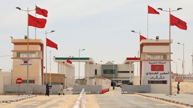
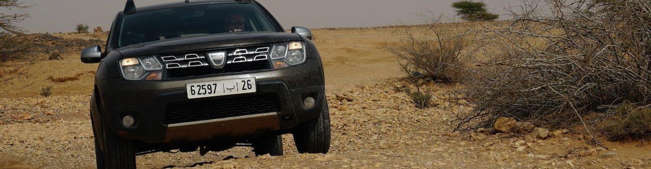
Border formalities from Morocco
Open from around 9 to 19.00, give or take. Best to arrive early and allow four hours from arriving at the Moroccan frontier at Guergarat (left) to leaving the Mauritanian post towards the Nouadhibou–Nouakchott road.
Have a read of this Dec ’25 HUBB post and the ones which follow which summarise the entire procedure.
Get stamped at Immigration/Passport Control (they will want to see evidence of your Mauritanian e-visa (like a print-out). Then go on to Customs, with your white TIP card and vehicle registration. They sign-off your vehicle, another office opposite stamps your passport. As with leaving TanMed port, there is a final barrier check where they keep a bit of paper the Customs issued.
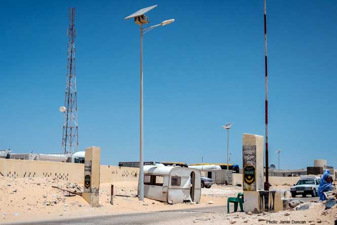
Cross ‘No Man’s Land’ on the Moroccan road, including about 1km of dirt. You soon reach the buildings at the start of the Mauritanian tarmac. Hyperventilating social media types routinely exaggerate the deadly experience of ‘crossing a live minefield’ to reach Mauritania. If you stick to the road there is zero risk.
Non-uniformed fixers await but you can manage without them. It’s up to you. Get visa and vehicle reg checked and passport stamped by the Gendarmerie (green uniform).
Once stamped to on to Customs compound and pay for a white A4 temporary import permit (TIP; €10 in dirhams or euros). Minimum 10 days – check the TIP duration and ask for longer unless transiting straight to Senegal. You must take photos of your vehicle and send them to a WhatsApp number.
Go on to another building via various checkpoints and have your photo and fingerprint taken and pay the €55 visa fee in euros cash.
Pass out of the border compound and by the old caravan buy vehicle insurance for 3, 10, 20, or 30 days, eg: €15 or 140 MAD for a moto for 20 days. Payment must be exact (Euros, Moroccan Dirham, or Ouguiya). You may be able to buy a forward-dated ‘Carte Brun’ for the ECOWAS West African countries (not Mauritania) for €75 (320 oogs). This is regional motor insurance, similar to the regional laisser passer ‘local carnet’.
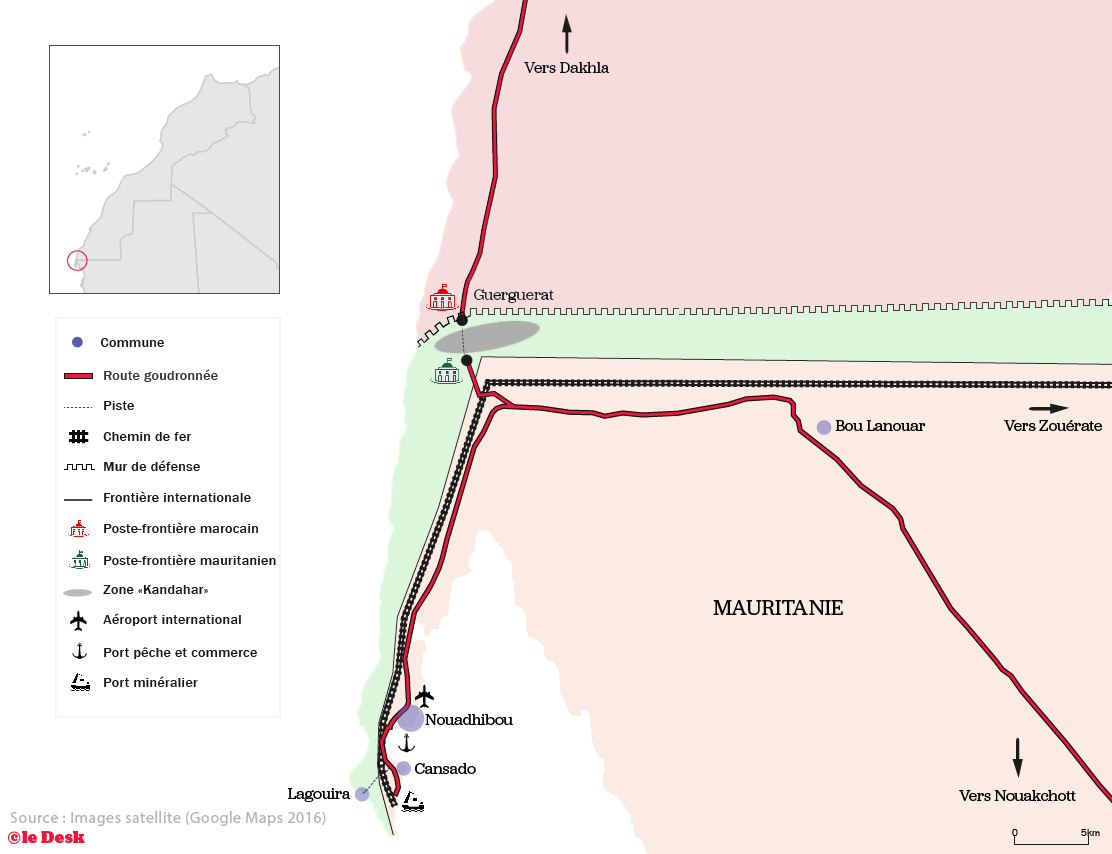
To Nouadhibou and on to Nouakchott
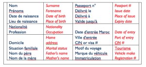
As in Moroccan Western Sahara, roadside checkpoints on the way tio Nouadhibou appreciate a pre-printed form (left) with your details as it saves them time. You can download a Word template by clicking this. Adapt as you wish but make at least two or three dozen. Chami with fuel is 270km from NKT.
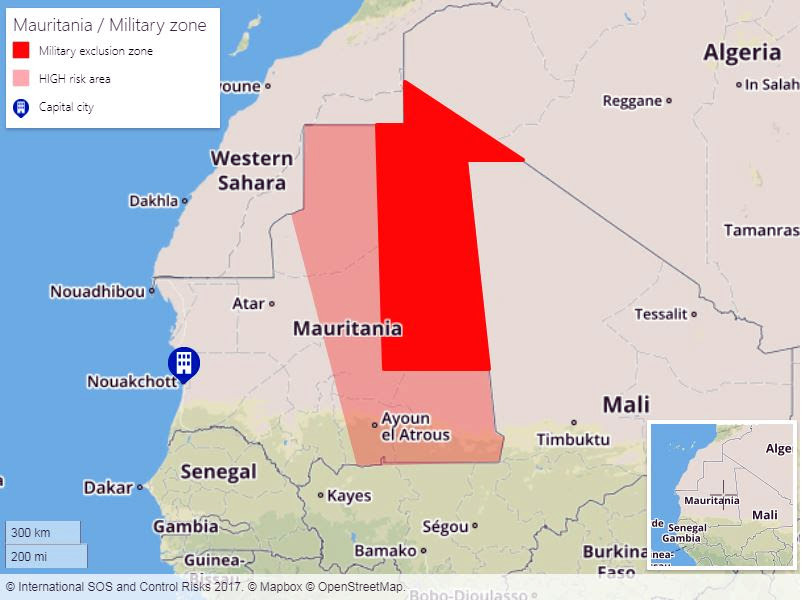
The Route d’Espoir from Nouakchott east to Nema is thought to be less safe. If you are a conspicuous foreigner venturing east beyond Ayoun may be unadvisable.
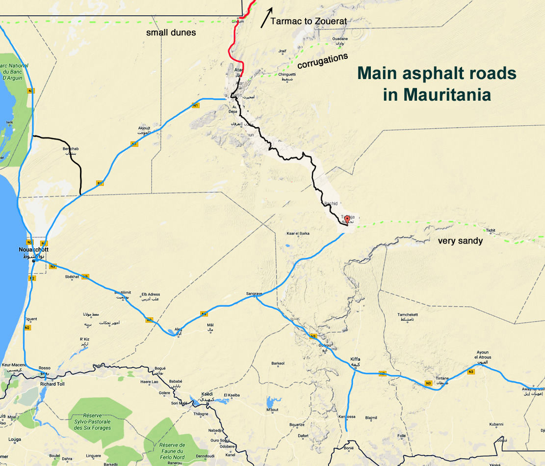
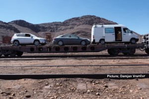
The Railway Piste and the ore train
The run east to Choum along the railway is a good introduction to the desert with easy navigation but with some extended low dune cordons. It gets soft and tussocky so for these sections motorbikes may find it easier on the coarse gravel between the rail tracks (no sleepers). Once you reach Choum there is asphalt south to Atar and north to Zouerat.
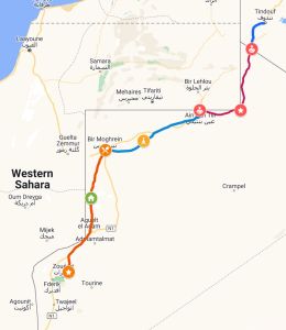
The Tindouf Route to Algeria
In 2023 Algeria and Mauritania agreed on a plan to build a new sealed road across the Sahara between Tindouf to Zouerat, and in 2024 the route was officially opened to all traffic. Because of Algerian visa and escort issues, it may be easier southbound, unless you can obtain a visa without an agency invite.
The map left shows the actual route which does not follow the colonial era road shown on many maps. More on the link above.
Desert pistes
A lot of overlanders shoot through Mauritania and don’t give the interior a chance. Others in less of a rush recognise that these days it’s the only real Saharan country left where you can drive anywhere they’ll allow without a mandatory guide, although lately, they might insist you get to a town before dark and camp by a police station.
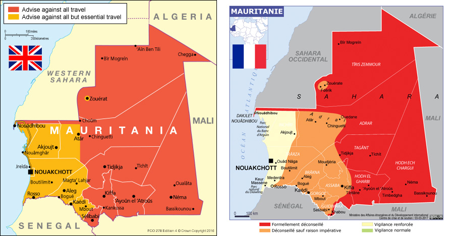
Note the differing views (left) from the British and French foreign ministries on where is safe to travel in Mauritania.
In my opinion and exchanges with other travellers, neither version is realistic though you may not want to stray too far east.
Tidjika has long been on the southern road network but in 2023 a 400-km road linked Atar and Tidjikja (left).
Note that the road is often covered in sand or barchan dunes so don’t expect to drive down in a low-slung sports car.
Elsewhere the canyons (or fault lines) of the Adrar plateau can get dune chocked or are slow and stony on the plateau stages, though Berbera guelta is worth a visit, along with the well-known tourist guelta of Terjit (entry fee), just out of Atar. Otherwise, a good run in a 4×4 would be up the sandy Tifoujar pass and out over the Amatlich erg back to the N1 highway near Akjoujt. Or out east to Ouadane, Guelb and Gallouiya then back west along the plain below the Adrar escarpment. Actual tracks are rare on the 800-km piste following the Dhar Tichit escarpment between Tidjikja to Nema via Tichit and, being close to Mali, Nema may not be a good place to end up these days.
North of Choum is little explored, but not out-of-bounds. You probably won’t make it to Chegga fort where Mali and Algeria meet, but you can travel off piste directly to Ain ben Tili.
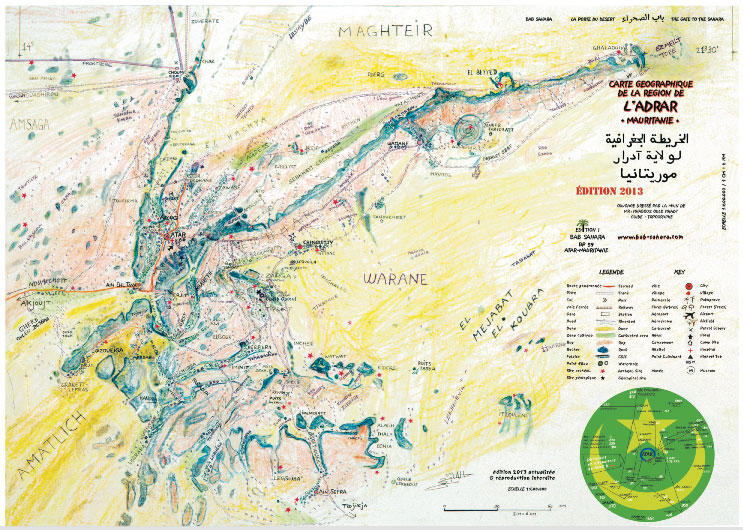
Bab Sahara is a popular place to stay in Atar. On the west side of town. That map above is produced by them and you’ll find vendors selling it in Atar and Chinguetti.
The southern border with Senegal
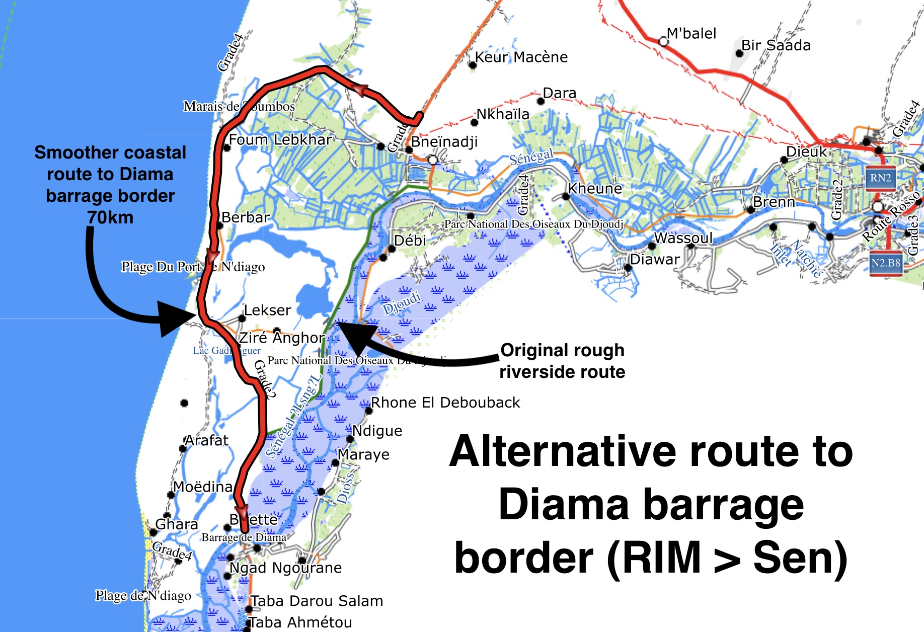
The ferry at Rosso still has a bad reputation for low-level scammery and extortionate fees, with officials working with uninformed locals. It has been like this for decades so southbound, many choose to avoid the ferry and head 30km downstream to the Diama Barrage (dam) at where things are less bad. There is no ferry here – you cross the tidal lifting bridge.
You leave the N2 highway way north of Rosso. The riverside road to the southwest is sealed for the first 20km, but after that gets famously rough. the map below shows an altertive coastal route to the border which is longer but less rough. More info on 2026 border procedures here.

Pingback: Trekking in Mauritania | Sahara Overland
Pingback: Fidelcrest Goes Africa Rally – FIDELCREST – Passion for Trading
Pingback: ‘A’ if for Atlantic Highway | Sahara Overland
Pingback: Mauritania: The Railway Piste (440km) | Sahara Overland